
Manatus Map facts for kids
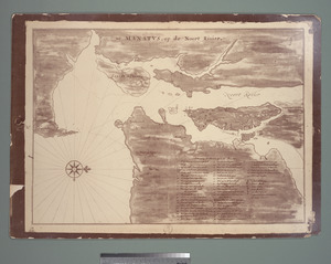
The Manatus Map is a special old map from 1639. It shows the area around what is now New York City and New Jersey when it was part of a Dutch colony called New Netherland. The map's full name in Dutch means "Manhattan situated on the North River." It helps us see what the land looked like, including the early settlement of New Amsterdam (which became New York City) and other Dutch towns. This map was made when Willem Kieft was in charge of New Netherland.

Contents
What is the Manatus Map?
The Manatus Map is a pictorial map. This means it uses pictures and symbols to show features like rivers, islands, and buildings. It gives us a snapshot of the New York–New Jersey Harbor Estuary in 1639. At that time, this area was a colony of the Netherlands, known as New Netherland.
Who Made the Map?
No one is completely sure who drew the original Manatus Map. Some experts, like Edward Van Winkle, thought it might be by Johannes Vingboons. He was a Dutch mapmaker who created many maps for the Dutch West India Company. This company was very important in setting up colonies like New Netherland.
Where Are the Copies Now?
The original Manatus Map is now lost. However, we have two copies made in the 1600s. These copies are very similar but have small differences. One copy is at the New York Public Library. The other copy was given to the Library of Congress by Henry Harrisse. The Harrisse copy is about 26.6 inches by 18.25 inches in size.
What Does the Map Show?
The Manatus Map is drawn with north pointing to the right. In the middle, you can see New York Bay and the North River (Hudson River). This river was called the "Noort Rivier" back then.
The map shows many important places:
- Manhattan Island: Called "Manatus Eylandt" on the map.
- Westchester and Bronx counties: Located to the north of Manhattan.
- Long Island and Coney Island: Found to the east. Coney Island was called "Conyni Eylant" or "Konyne Eylandt."
- Sandy Hook and Highlands, New Jersey: To the south. Sandy Hook was "Sant Punt."
- Staten Island: Known as "Staten Eylant."
- Other areas to the west: Including Newark Bay and several rivers like the Hackensack and Passaic.
The map also marks places where Native American people lived, especially in what is now Brooklyn.
Understanding the Map's Key
The Manatus Map includes a special "key" or legend. This key uses numbers to point out important places on the map. It shows properties owned by the Dutch West India Company (called WIC) and by early Dutch settlers.
These properties were often:
- Bouweries: These were like farms or homesteads. They included houses and other buildings.
- Plantations: These were larger farms, sometimes worked by enslaved people owned by the company.
The key lists many specific properties and their owners. For example, "Bowery Number One" was a company farm with a large house for the Director of New Netherland. Other numbers point to farms owned by early settlers like Wouter van Twiller (who had a tobacco plantation) or Cornelis van Tienhoven.
Important Places on the Map
Besides the numbered properties, the map's key also uses letters to mark other significant locations:
- A. Fort Amsterdam: This was the main fort and center of the New Amsterdam settlement.
- B. Grain Mill: A mill used to grind grain into flour.
- C. Sawmill: A mill used to cut wood.
- D. Sawmill: Another sawmill.
- F. Quarter of the Blacks/Company slaves: This area was where enslaved people lived and worked for the Dutch West India Company.
