
Manorhaven, New York facts for kids
Quick facts for kids
Manorhaven, New York
|
||
|---|---|---|
| Incorporated Village of Manorhaven | ||

Manorhaven Village Hall in 2011
|
||
|
||
| Motto(s):
"The Pearl of Manhasset Bay"
|
||

Location in Nassau County and the state of New York
|
||

Manorhaven, New York
Location in Long Island

Manorhaven, New York
Location in New York
|
||
| Country | ||
| State | ||
| County | Nassau | |
| Town | North Hempstead | |
| Incorporated | 1930 | |
| Area | ||
| • Total | 0.63 sq mi (1.64 km2) | |
| • Land | 0.47 sq mi (1.22 km2) | |
| • Water | 0.17 sq mi (0.43 km2) | |
| Elevation | 16 ft (5 m) | |
| Population
(2020)
|
||
| • Total | 6,956 | |
| • Density | 14,831.56/sq mi (5,720.55/km2) | |
| Demonym(s) | Manorhavenite; Port Washingtonian | |
| Time zone | UTC-5 (Eastern (EST)) | |
| • Summer (DST) | UTC-4 (EDT) | |
| ZIP code |
11050
|
|
| Area code(s) | 516, 363 | |
| FIPS code | 36-45106 | |
| GNIS feature ID | 0956378 | |

Manorhaven is a small village located in Nassau County, New York. It sits on the North Shore of Long Island. Manorhaven is considered part of the larger Port Washington area. In 2020, about 6,956 people lived there.
This village is found on the Cow Neck Peninsula, which is part of the Town of North Hempstead.
Contents
Village History
Manorhaven became an official village in 1930. This happened because people heard that nearby Port Washington was planning to become a city. Local residents chose the name "Manorhaven" because they felt it described the area well.
Later, in 1982, Manorhaven grew a little bigger. It added about 20,000 square feet (1,858 square meters) of land from an area that was not yet part of any town or village in Port Washington.
Geography and Location

Manorhaven is located at specific coordinates: 40°50′31″N 73°42′50″W.
The United States Census Bureau says the village covers about 0.6 square miles (1.6 square kilometers) in total. Most of this area, about 0.5 square miles (1.2 square kilometers), is land. The rest, about 0.2 square miles (0.4 square kilometers), is water. This means a good part of the village is near water!
Population and People
| Historical population | |||
|---|---|---|---|
| Census | Pop. | %± | |
| 1940 | 484 | — | |
| 1950 | 1,819 | 275.8% | |
| 1960 | 3,566 | 96.0% | |
| 1970 | 5,488 | 53.9% | |
| 1980 | 5,384 | −1.9% | |
| 1990 | 5,672 | 5.3% | |
| 2000 | 6,138 | 8.2% | |
| 2010 | 6,556 | 6.8% | |
| 2020 | 6,956 | 6.1% | |
| U.S. Decennial Census | |||
Manorhaven's population has grown a lot over the years. In 1940, only 484 people lived here. By 2020, the population had increased to 6,956 people.
Population in 2010
In 2010, there were 6,556 people living in Manorhaven. The village is home to people from many different backgrounds. About 52.6% of the people were White, and 17.5% were Asian. People of Hispanic or Latino background made up about 27.1% of the population. This shows that Manorhaven is a diverse community.
Education for Students
School District Information
All children living in Manorhaven attend public schools in the Port Washington Union Free School District. This means students go to schools within the Port Washington area.
Local Library Services
Manorhaven is also part of the Port Washington Library District. This gives everyone in the village access to the local library and its resources.
Village Infrastructure
Transportation and Roads

Manorhaven has several important roads. These include Manhasset Avenue, Manorhaven Boulevard, Orchard Beach Boulevard, Sands Point Road, and Shore Road.
Street Layout and Names
Most streets in Manorhaven are laid out in a grid pattern, like a checkerboard. However, Manhasset Avenue is different; it cuts across the grid diagonally. Many streets are named after local Native American tribes or places, like Mohegan Avenue. Other streets are named after types of trees, such as Cottonwood Road.
Bus Services

As of July 2024, Manorhaven has one bus route called the n23. This bus is part of the NICE bus system.
Essential Utilities
Natural Gas Supply
National Grid USA provides natural gas to homes and businesses in Manorhaven that use gas lines.
Electricity Service
PSEG Long Island is responsible for providing electricity to all homes and businesses throughout Manorhaven.
Water and Sewage Systems
The village has its own sanitary sewer system. Waste from this system is sent to and treated by the Port Washington Water Pollution Control District. For clean water, Manorhaven gets its supply from the Port Washington Water District.
Healthcare and Safety Services
Nearby Healthcare
There are no hospitals directly within Manorhaven. The closest hospital is St. Francis Hospital, which is in the nearby village of Flower Hill.
Fire Protection
The entire Village of Manorhaven is covered by the Port Washington Fire District. This district provides fire protection services to the community.
Police Services
The Nassau County Police Department serves Manorhaven. Specifically, the Sixth Precinct of the police department is responsible for the village. They even have a police booth located on Manorhaven Boulevard.
Notable People from Manorhaven
- Gina Sillitti – She is a politician. As of August 2021, Gina Sillitti represents the area in the New York State Assembly.
Images for kids
-
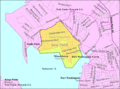
U.S. Census Map
-
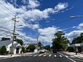
Manorhaven Boulevard in 2022
-
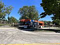
A Mineola-bound n23 bus in Manorhaven in 2022
See also
 In Spanish: Manorhaven para niños
