
Mapulaca facts for kids
Quick facts for kids
Mapulaca
|
|
|---|---|
|
Municipality
|
|

Panoramic View of Mapulaca
|
|

Mapulaca
Location in Honduras
|
|
| Country | Honduras |
| Department | Lempira |
| Area | |
| • Total | 32 km2 (12 sq mi) |
| Population
(2015)
|
|
| • Total | 4,314 |
| • Density | 134.8/km2 (349/sq mi) |
Mapulaca is a small town, also called a municipality, in the Lempira department of Honduras. It's one of the smallest towns in the southern part of the Lempira department.
You can reach Mapulaca by traveling through several other towns like Santa Rosa de Copán, San Marcos de Ocotepeque, and La Virtud. The journey usually takes about 5 to 6 hours. Mapulaca is very close to the border with El Salvador. There's a special "Hanging Bridge" (El Puente Colgante) that connects Mapulaca to Sonsonate municipality in El Salvador. There's also a newer bridge called "Puente La Integracion."
Contents
History of Mapulaca
Mapulaca was officially founded a very long time ago, on October 30, 1692. In a census taken in 1791, it was part of an area known as "Curato de Cerquin."
The town has old land ownership documents from March 10, 1817. These documents were granted by the "Convent" of Gracias and signed by King Felipe IV. Later, in 1889, Mapulaca became a municipality within the Candelaria district.
Geography and Location
Mapulaca is located about 300 meters (or about 984 feet) above sea level. It sits after you come down from the "Congolón" mountain. The town is surrounded by tall hills and dry subtropical forests. There are also some flat areas where people grow crops and where some homes are built.

Mapulaca's Borders
Mapulaca shares its borders with several other places:
- North: Gualcince municipality.
- South: El Salvador.
- East: Candelaria and Virginia municipalities.
- West: La Virtud municipality.
- The total area of Mapulaca is 32 square kilometers.
What Mapulaca Produces
The main way people make a living in Mapulaca is through trade and buying and selling goods. This is especially true because the border with El Salvador is only 3 kilometers away from the main town.
People also grow corn and beans. On a smaller scale, they raise cattle and make milk products. Most of these goods are for people living in Mapulaca. The town has had electricity and mobile phone service for many years. Water comes from wells. You can find two hardware stores and several grocery stores in Mapulaca. Some houses also sell gasoline or diesel fuel.
Mapulaca's People
In 2001, the population of Mapulaca was 3,866 people. By 2015, it was estimated to be around 4,314 people.
- Villages: Mapulaca has 5 villages.
- Settlements: There are 35 smaller settlements within the municipality.
Who Lives in Mapulaca
According to a census in 2013, Mapulaca municipality had 4,261 residents. Most of the people (98.31%) were Indigenous, with 98.26% being Lenca people. A smaller number were Mestizo (1.43%), Black or Afro-Honduran (0.14%), or White (0.09%).
Fun Things to See
The "Puente Colgante" (Hanging Bridge) is a famous spot. It connects Mapulaca to the Chalatenango municipality in El Salvador. This bridge was built by a Swiss architect named Toni El Suizo. He built many hanging bridges in Honduras after Hurricane Mitch in 1998.
Tourists sometimes swim in the Lempa River, but its currents can be strong and dangerous. There are also several smaller streams that flow into the Lempa River, which are nice places to cool off. Mapulaca has one hostel where visitors can stay and eat at a restaurant.
- Local Holidays: Mapulaca celebrates San Juan de Dios' Day on March 8.
Gallery
-
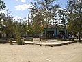
Central Park in Mapulaca
-
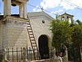
The Small Church in Mapulaca
-
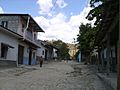
A Street in Mapulaca
-
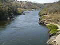
Lempa River on the border, near Mapulaca
-
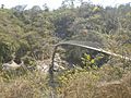
The Hanging bridge to El Salvador
-
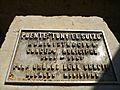
In Honor to the Bridge Maker
-
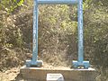
Welcome to El Salvador


See also
 In Spanish: Mapulaca para niños
