Marble City, Oklahoma facts for kids
Quick facts for kids
Marble City, Oklahoma
|
|
|---|---|
| Nickname(s):
"Marble"
|
|

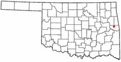
Location of Marble City, Oklahoma
|
|
| Country | United States |
| State | Oklahoma |
| County | Sequoyah |
| Named for | nearby marble deposits |
| Area | |
| • Total | 0.41 sq mi (1.05 km2) |
| • Land | 0.41 sq mi (1.05 km2) |
| • Water | 0.00 sq mi (0.00 km2) |
| Elevation | 623 ft (190 m) |
| Population
(2020)
|
|
| • Total | 186 |
| • Density | 458.13/sq mi (176.73/km2) |
| Time zone | UTC-6 (Central (CST)) |
| • Summer (DST) | UTC-5 (CDT) |
| ZIP code |
74945
|
| Area code(s) | 539/918 |
| FIPS code | 40-46450 |
| GNIS feature ID | 2408174 |
Marble City (often called Marble) is a small town in Sequoyah County, Oklahoma. It is part of the Fort Smith, Arkansas-Oklahoma area. In 2020, the town had 186 people living there. This was a decrease from 263 people in 2010.
Contents
History of Marble City
The land where Marble City is today was once part of Lovely County. This was in the Arkansas Territory until 1829.
Early Settlements and Post Offices
In 1829, the United States government began moving Western Cherokees to this area. It was then called Nicksville. Other settlers were asked to leave. The Arkansas government gave up its claim to the land. This area then became part of Indian Territory.
A post office named Kidron opened here in 1835. It served the Cherokee people. In 1858, the post office moved and was renamed Marble Salt Works. Another Kidron post office opened in 1859 near Dwight Mission. It closed in 1869.
Later in 1869, a new post office called Kedron opened.
Marble Quarrying and Railroad
By 1895, people started digging for marble in a big way. The Kansas City, Pittsburg and Gulf Railroad (now Kansas City Southern Railway) built train tracks through the area. The Kedron post office moved closer to the railroad and the marble quarry. It was then renamed Marble.
The town was named Marble because it was near Oklahoma's only real marble deposits. Digging for marble began in 1895. The Ozark Marble Company worked the quarry from 1906 to 1914. They used the marble for building projects.
Famous Buildings Using Marble City Stone
Marble from Marble City was used in important buildings. One was the Pioneer Telephone Building in Oklahoma City. Another was the Administration Hall at Rice Institute. This building is now Lovett Hall at Rice University. It used red bricks, pink granite, and gray marble from Marble City.
Long-Serving Mayor
Watie Davault was the mayor of Marble City for 47 years. He retired in 1961.
Geography of Marble City
Marble City is about 9 miles (14 km) north of Sallisaw.
The town covers about 0.4 square miles (1.05 square kilometers). All of this area is land.
Population Changes Over Time
| Historical population | |||
|---|---|---|---|
| Census | Pop. | %± | |
| 1910 | 342 | — | |
| 1920 | 344 | 0.6% | |
| 1930 | 168 | −51.2% | |
| 1940 | 214 | 27.4% | |
| 1950 | 285 | 33.2% | |
| 1960 | 271 | −4.9% | |
| 1970 | 299 | 10.3% | |
| 1980 | 294 | −1.7% | |
| 1990 | 232 | −21.1% | |
| 2000 | 242 | 4.3% | |
| 2010 | 263 | 8.7% | |
| 2020 | 186 | −29.3% | |
| U.S. Decennial Census | |||
In 2000, there were 242 people living in Marble City. There were 73 households and 58 families. The average household had about 3.32 people. The average family had about 3.78 people.
About 35.1% of the people were under 18 years old. About 12.4% were 65 years or older. The average age in the town was 28 years. For every 100 females, there were about 105 males.
Historic Places in Marble City
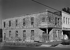
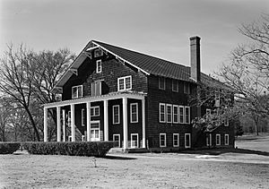
Two important historic places are in Marble City. They are the Citizens State Bank and the Dwight Presbyterian Mission. These places are listed on the National Register of Historic Places.
See also
 In Spanish: Marble City (Oklahoma) para niños
 | Percy Lavon Julian |
 | Katherine Johnson |
 | George Washington Carver |
 | Annie Easley |


