
Marmion, Western Australia facts for kids
Quick facts for kids MarmionPerth, Western Australia |
|||||||||||||||
|---|---|---|---|---|---|---|---|---|---|---|---|---|---|---|---|

Radbourn Street, Marmion
|
|||||||||||||||
| Established | 1970s | ||||||||||||||
| Postcode(s) | 6020 | ||||||||||||||
| Area | 1.2 km2 (0.5 sq mi) | ||||||||||||||
| Location | 17 km (11 mi) NW of Perth | ||||||||||||||
| LGA(s) | City of Joondalup | ||||||||||||||
| State electorate(s) | Carine | ||||||||||||||
| Federal Division(s) | Moore | ||||||||||||||
|
|||||||||||||||
Marmion is a cool coastal suburb located north of Perth, the capital city of Western Australia. It's part of the City of Joondalup, which is its local government area. Marmion is known for its beautiful beaches and connection to the Indian Ocean.
Contents
Marmion's History
Marmion got its name from a man named Patrick Marmion. He was a master whaler, which means he was in charge of a whaling station back in 1849. You can still find some parts of his old whaling station in the nearby suburb of Sorrento. There's even a monument to Patrick Marmion in Geneff Park in Sorrento.
Long before European settlers arrived, the Whadjuk Aboriginal people lived in this area. They called it Mooro. They would gather lots of abalone and other shellfish from the reefs close to the coast.
In the 1930s, the area became popular with fishermen. Many small boatsheds and shacks were built here. A whaling station was also set up. In 1940, the government officially marked the area as a townsite. However, it didn't really grow much until the late 1950s. That's when the Marmion postal district was approved.
At first, the only building was the primary school, which opened in 1956. It started as a school with just two teachers. People nicknamed it "The Little School in the Bush." Until the mid-1970s, you could only reach it by a dirt track! By 1961, the area near the coast was mostly developed. The Marmion Angling and Aquatic Club was also started around this time. The rest of the suburb was built between 1973 and 1976.
Where is Marmion?
Marmion is surrounded by different roads and the ocean. To the north, you'll find High Street and Freeman Way. Marmion Avenue is to the east. The Beach Road coastal part is to the south. To the west, you'll see West Coast Drive and the big Indian Ocean.
In 2006, a count of people (called a census) showed that 2,106 people lived in Marmion. They lived in 736 homes.
Things to Do and See in Marmion
Marmion is mainly a place where people live. For everyday shopping, residents go to the Marmion Village shopping centre on Sheppard Way. For bigger shopping trips, people usually visit Karrinyup Shopping Centre or Centro Warwick.
The suburb has its own school, Marmion Primary School. Older students in the area go to Carine Senior High School. There's also Braden Park, a large park with play equipment and lights. It's located close to the shopping centre.
The Marmion Angling and Aquatic Club is a popular spot for boating and fishing. It's located right above Marmion Beach. The club has a special room where you can hold events while looking out over the Indian Ocean. Off the coast, you'll find the amazing Marmion Marine Park. This park is a protected area where many different kinds of marine animals live. It's like an underwater nature reserve!
Getting Around Marmion
Transperth provides bus services in Marmion. If you're in the western part of Marmion, you can catch the 423 bus route. This bus travels between Warwick and Stirling train stations. For the eastern part of the suburb, the 441 bus runs along Marmion Avenue. All these bus services are run by Swan Transit.
Bus Routes
- 423 Bus: Travels from Warwick Station to Stirling Station. It uses Freeman Way, Cliff Street, and Beach Road.
- 441 Bus: Goes from Warwick Station to Whitfords Station. This bus serves Freeman Way.
- 442 Bus: Also travels from Warwick Station to Whitfords Station. This route uses Marmion Avenue.
Schools in Marmion
Marmion has one public school run by the state government. It's called Marmion Primary School. This school teaches students from kindergarten all the way up to Year 6.
Images for kids
-
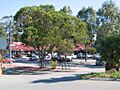
Marmion Village shopping centre in 2006

