
Marmion Avenue facts for kids
Quick facts for kids Marmion AvenueWestern Australia |
|
|---|---|
 |
|
| General information | |
| Type | Highway |
| Length | 40.4 km (25 mi) |
| Opened | 1960s |
| Route number(s) | |
| Major junctions | |
| South end | |
|
|
| North end | Yanchep Beach Road, Yanchep |
| Location(s) | |
| Major suburbs | Karrinyup, Hillarys, Clarkson, Butler, Alkimos, Yanchep |
| Highway system | |
| Highways in Australia National Highway • Freeways in Australia Highways in Western Australia |
|
Marmion Avenue is a very important road in the northern coastal suburbs of Perth, Western Australia. It stretches for about 40 kilometers (25 miles). This road connects the suburb of Trigg in the south to Yanchep in the north.
Marmion Avenue is part of State Route 71. It joins up with West Coast Highway at its southern end. This makes it a key route for people traveling along the coast.
Contents
What is Marmion Avenue Like?
Marmion Avenue is a major road that runs mostly parallel to the Indian Ocean coastline. It goes through many residential areas. It also passes some undeveloped land, especially north of Currambine. The road ends in Yanchep.
This road has four lanes, with two lanes going in each direction. This helps a lot with traffic flow. Most of the time, the speed limit is 70 kilometers per hour (about 43 mph). There are some parts where it's 80 km/h (about 50 mph). Near Yanchep, the speed limit drops to 60 km/h (about 37 mph).
In February 2023, many parts of Marmion Avenue had their speed limits changed. They used to be 80 km/h. Now, the maximum speed through traffic lights is 70 km/h. This change helps to keep drivers and pedestrians safer.
From Trigg to Currambine
Marmion Avenue begins in Trigg. It starts as a continuation of West Coast Highway. The road first passes by the Hamersley Public Golf Course. It also goes through the suburbs of Trigg, North Beach, and Karrinyup.
Further north, Marmion Avenue crosses Reid Highway. It then travels past the Star Swamp Reserve. It also goes through Carine before reaching Beach Road. After this, the road enters the City of Joondalup.
As it continues north, Marmion Avenue passes through many residential areas. It has intersections with important roads like Warwick Road and Hepburn Avenue. You'll also see the Westfield Whitford City shopping centre nearby. The road keeps going north, passing other suburbs and shopping areas like Currambine Central Shopping Centre. It then reaches Burns Beach Road.
North of Currambine
After Burns Beach Road, Marmion Avenue continues through more residential areas. It then enters the City of Wanneroo. Here, it travels through undeveloped land in Tamala Park. This section provides access to the Tamala Park Rubbish Disposal Site.
The road then goes through the Clarkson and Butler areas. It connects with roads like Neerabup Road and Hester Avenue. These intersections also link to parts of Anchorage Drive.
Marmion Avenue then heads north through newer suburbs like Alkimos and Eglinton. These areas are still growing. After about 8 kilometers, Marmion Avenue reaches Yanchep. It ends at a large roundabout with Yanchep Beach Road. The road actually continues a bit further as Splendid Avenue, which helps connect to new homes and a local sports ground in Yanchep.
How Marmion Avenue Grew Over Time

Marmion Avenue was first built in the late 1960s. It was designed to serve the new suburbs that were growing north of Perth. The road originally started at Beach Road in Marmion. This is how it got its name!
In the early 1980s, Marmion Avenue was a two-lane road. It connected Marmion and Mullaloo Beach. But in 1984–85, it was extended south to Karrinyup Road. At the same time, West Coast Highway was moved further inland. This made Marmion Avenue a very important road for Perth's coastal suburbs.
The road was then made wider, with two lanes in each direction, up to Whitfords Avenue. In 1986, it was given the name State Route 71. From then on, it was slowly extended further north. It reached Burns Beach Road in 1991 and Quinns Road in the mid-1990s. Finally, in 2001, the entire road was widened to two lanes in each direction all the way to its end.
In 2000 and 2001, Reid Highway was extended to meet Marmion Avenue. This gave people another way to travel east. This part of Reid Highway was later upgraded to four lanes in 2015–2016.
There were some delays, but Marmion Avenue was extended even further north to Yanchep. This new section opened in November 2008. At first, it only had one lane in each direction. But plans were made to widen it later, which started happening in 2018. This extension was very important because it allowed new areas like Alkimos and Eglinton to start being built.
To make roads safer, fixed red light and speed cameras were put in at the Marmion Avenue and Hepburn Avenue intersection on July 1, 2010. These cameras help to reduce accidents.
In 2016, the intersection at Marmion Avenue and Mullaloo Drive was improved. It used to be a T-junction, but it was changed into a roundabout. This was done because it was a busy intersection with many crashes. The upgrade made it safer for cars, bikes, and people walking.
More improvements happened in 2016 and 2017. The intersections at Hepburn Avenue and Whitfords Avenue were upgraded to help traffic flow better and improve safety. These intersections were very busy, with 72,000 vehicles using them every day. The upgrades included longer turning lanes, better paths for walking and cycling, and new traffic lights. CCTV cameras were also installed to help monitor traffic.
In 2017, Marmion Avenue was widened to four lanes between Lukin Drive and Butler Boulevard. This project helped to handle the growing number of cars in the area.
Starting in 2018, work began to upgrade Marmion Avenue north of Camborne Parkway. It was changed from a two-lane road to a four-lane road. This big project is being done in stages and is expected to be finished by 2020.
What's Next for Marmion Avenue?
There are plans to extend Marmion Avenue even further north to Two Rocks. Currently, work is being done to extend it to Toreopango Avenue in Yanchep. This will create new local road connections.
The long-term plan for Marmion Avenue was to make it a six-lane road between Alkimos and Yanchep. The rest of the road would become four lanes. Also, the intersection with Yanchep Beach Road might be changed to allow traffic to flow without stopping by 2050. However, these big plans have been put on hold for now. Perth's future transport plans are still being reviewed.
Images for kids
-
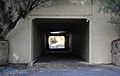
An underpass below Marmion Avenue, near Whitfords Avenue
-
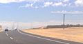
Single-laned extension of Marmion Avenue when opened in 2008, heading north in the then-undeveloped suburb of Alkimos
-
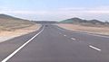
Single-laned extension of Marmion Avenue when opened in 2008, heading north in the then-undeveloped suburb of Eglinton


