Eglinton, Western Australia facts for kids
Quick facts for kids EglintonPerth, Western Australia |
|||||||||||||||
|---|---|---|---|---|---|---|---|---|---|---|---|---|---|---|---|

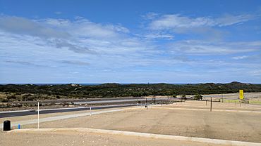
Looking from Allara Estate, over Marmion Avenue towards the Indian Ocean
|
|||||||||||||||
| Postcode(s) | 6034 | ||||||||||||||
| Area | 10 km2 (3.9 sq mi) | ||||||||||||||
| Location | 44 km (27 mi) from Perth CBD | ||||||||||||||
| LGA(s) | City of Wanneroo | ||||||||||||||
| State electorate(s) | Butler | ||||||||||||||
| Federal Division(s) | Pearce | ||||||||||||||
|
|||||||||||||||
Eglinton is a suburb in Perth, Western Australia. It's about 44 kilometers (27 miles) north of Perth's city center, right by the Indian Ocean. Most of Eglinton is covered in native bushland, like banksia trees and other plants found on the Swan Coastal Plain. But recently, new homes and neighborhoods have been built, and a town center is planned for the future.
Eglinton is part of the City of Wanneroo. It shares borders with Yanchep to the north, Carabooda to the east, and Alkimos to the south. The government is looking at this area, along with Alkimos, as a future urban region.
New housing areas are being built in Eglinton, including the Amberton estate by Stockland and the Allara Estate by Satterly. The Allara Estate is special because it's one of only two places in Western Australia to get a six-star energy rating for its homes.
Contents
Discovering Eglinton's Past
Eglinton got its name in 1974. It was named after a ship called the Eglinton. This ship was wrecked on rocks near Alkimos, and those rocks are now named after the ship too.
Ancient History and Local Legends
Before Europeans arrived, the Noongar people, specifically the Mooro tribe, lived in this northern Perth area for over 40,000 years. They used the many wetlands on the Swan Coastal Plain for food and water. A local story says that Pipidinny Swamp, in eastern Eglinton, was formed from the blood and meat of a crocodile's tail. This happened after a fight between the crocodile and a shark, as the crocodile walked back to the Swan River.
Early European Settlement and Trails
In 1865, European settlers started using Aboriginal paths along the lakes. These paths became a route for moving farm animals from Dongara to Fremantle. A part of this old route, between Joondalup and Yanchep, became part of the Bicentennial Heritage Trails Network in 1988. Today, it's known as the Yaberoo Budjara Heritage Trail.
Even today, much of Eglinton is bushland. However, there are some small farms along Wanneroo Road and Pipidinny Road. New housing areas are also growing near Marmion Avenue.
Future Plans for Eglinton
In May 2006, plans were announced for a new "satellite city" in the Alkimos-Eglinton area. This city would be like a smaller version of Perth, with everything people need.
What the Future City Might Include
LandCorp estimated that about 55,000 people could live in this area once it's finished. The plans include hospitals, universities, large shops, businesses, and fun places for recreation. The first land blocks for homes were expected to be sold in 2008.
However, the Environmental Protection Authority (EPA) had some worries in November 2005. They said the plans might harm important natural areas and historical sites. The EPA suggested that much more land should be set aside as nature reserves.
Water Treatment for the Region
A major new wastewater treatment plant for the Perth area was built in Eglinton. It's designed to collect and treat water from Two Rocks down to the existing Beenyup treatment plant area.
Eglinton's Location and People
Eglinton is located between the future Mitchell Freeway on its east side and the Indian Ocean on its west side.
The number of people living in Eglinton has been growing. In the 2016 census, there were 2,365 residents. By 2021, this number had increased to 3,705.
Local Facilities and Nature
Currently, Eglinton doesn't have many traditional facilities like big shopping centers. However, the Amberton and Allara estates are being developed. Many houses have been built, more are under construction, and land blocks are ready for building.
The Amberton estate is connected to Shorehaven, which will have important services and facilities.
Exploring Eglinton's Natural Beauty
Before new roads were built, you could only reach Eglinton by Pipidinny Road. This road goes through Pipidinny Swamp and gets very close to the beach. You can see the Alkimos shipwreck from the nearby coast. The beaches here are mostly untouched and can be reached by sand tracks, but a paved road is being built.
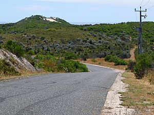
Eglinton has a lot of native bushland, including different types of trees and plants. You can find Xanthorrhoea preissii (also called "black boys"), banksia trees, sheoak trees, and Nuytsia floribunda. Some areas have been affected by vehicles, clearing for animals, fires, and rabbits.
Getting Around Eglinton
In 2008, Marmion Avenue was extended through Eglinton. Before this, the suburb didn't have good road access.
Bus Services
Transperth runs bus services in Eglinton.
- Route 490: Travels from Butler Station to Two Rocks Shopping Centre, using Marmion Avenue.
- Route 491: Travels from Butler Station to Yanchep, also using Marmion Avenue.
Train Services
The Yanchep line train route goes through Eglinton. The Eglinton railway station is part of this line, making it easier for people to travel by train.
 | Ernest Everett Just |
 | Mary Jackson |
 | Emmett Chappelle |
 | Marie Maynard Daly |


