Clarkson, Western Australia facts for kids
Quick facts for kids ClarksonPerth, Western Australia |
|||||||||||||||
|---|---|---|---|---|---|---|---|---|---|---|---|---|---|---|---|

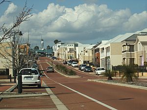
Renshaw Boulevard, Clarkson, facing east
|
|||||||||||||||
| Established | 1990s | ||||||||||||||
| Postcode(s) | 6030 | ||||||||||||||
| Area | 6.6 km2 (2.5 sq mi) | ||||||||||||||
| Location | 34 km (21 mi) NNW of Perth CBD | ||||||||||||||
| LGA(s) | City of Wanneroo | ||||||||||||||
| State electorate(s) | Burns Beach | ||||||||||||||
| Federal Division(s) | Pearce | ||||||||||||||
|
|||||||||||||||
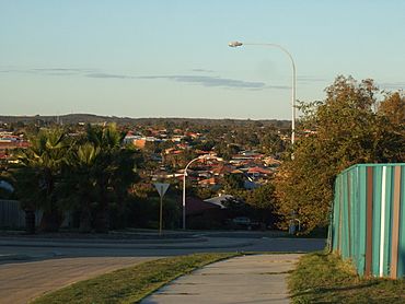
Clarkson is a lively suburb located north of Perth, Western Australia. It's about 34 kilometres (21 miles) from Perth's city centre. Clarkson is part of the City of Wanneroo.
Even though it's mostly a place where people live, Clarkson also acts like a town centre. It has many shops and services for people in the area. The suburb has its own train station on the Joondalup railway line. This makes it a key transport spot for many nearby suburbs.
Contents
Where is Clarkson Located?
Clarkson is bordered by Mindarie to the west. To the north, you'll find Merriwa and Ridgewood. The Joondalup railway line separates Clarkson from the Neerabup National Park in the east. South of Clarkson is Tamala Park, which is mostly empty land.
The suburb is also quite close to the ocean. It's only about 2 kilometres (1.2 miles) from the Indian Ocean. You can easily reach the beautiful coastlines of Claytons Beach and Quinns Beach.
Clarkson's Past: A Brief History
How Did Clarkson Get Its Name?
The name "Clarkson" comes from a family of sheep farmers. This family, called the Clarksons, had been leasing land here since the 1800s. The area was first named "Mindarie" in 1979. But in 1985, the names "Clarkson" and "Mindarie" were swapped. This happened because a company wanted to build the Mindarie Keys Marina nearby.
Early Settlers and Sheep Farms
The first European settler in this area was Barnard Drummond Clarkson. He was a sheep farmer who also owned land in Toodyay. In 1888, Clarkson leased a huge area of land. This land included what we now know as Mindarie, Clarkson, Quinns Rocks, and Merriwa. His sheep farm was called the Mindarie Pastoral Company. The Clarkson family used these lands mainly for herding sheep for many years.
Today, you can still see the ruins of the Clarksons' first home. This historic site is preserved in Riverlinks Park on Connolly Drive.
Growing into a Suburb
The Mindarie Pastoral Company lands were sold in 1952. For many years after that, nothing much happened there. Then, in the early 1990s, the area started to develop. This was after the Mindarie Marina was finished and new homes were built nearby. The north-eastern part of Clarkson, near the high school, was developed in 1995. The suburb continued to grow throughout the 2000s, with more and more people moving in.
Most of Clarkson has homes with gardens and lots of parks. There are also some two-storey apartment buildings. You can find these along Ocean Keys Boulevard, near the train station. More apartments are located closer to the shopping centre.
Somerly: A Modern Community
Somerly is a newer part of Clarkson. It's a large housing and business area built around the train station. It was finished in 2008. This project aimed to create a "community within a community." It offered businesses, fast internet, and special landscaping for new homeowners.
Because of the Somerly development, Clarkson became one of the biggest suburbs in Perth's northern area. Its population grew to almost 12,000 people.
Catalina: Future Plans
There are plans for a new residential area called "Catalina." This estate is expected to be developed in the future. It will be located south of Neerabup Road. Even though this land is currently part of Clarkson, the developers hope it will become its own suburb one day.
Who Lives in Clarkson?
Clarkson has a growing population. In 2006, about 7,082 people lived there. Experts predict the population will keep growing a lot, possibly reaching over 18,000 by 2026.
Many people in Clarkson were born in Australia. However, a good number of residents also come from the United Kingdom. Other major groups of immigrants are from English-speaking countries like New Zealand and South Africa.
Clarkson is known for having a very young population. The average age is 28, which is much younger than the average age in Australia. Most people in Clarkson have incomes similar to the national average.
Many residents in Clarkson identify as Christian. There are several churches in the suburb. These include Clarkson Seventh-day Adventist Community Church and St. Andrew's Catholic Church. A good number of people also say they have no religion.
Clarkson also has a higher percentage of Indigenous Australians compared to the national average.
What Can You Do in Clarkson?
Clarkson is a busy area with many things to do and places to go. It's a major shopping and retail hub for the northern suburbs.
Shopping and Services
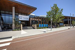
The main road, Ocean Keys Boulevard, is home to the Ocean Keys Shopping Centre. This is a large shopping mall with over 100 stores. You can find popular shops like ALDI, Kmart, Coles, TK Maxx, and JB Hi-Fi. There's also a Woolworths supermarket nearby.
Around the shopping centre, you'll find many other businesses. These include a large Bunnings Warehouse, a post office, and petrol stations. There are also car dealerships.
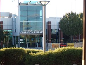
You can find many restaurants and take-away places west of the shopping centre. Clarkson also has three medical centres for healthcare needs. The Clarkson Library is located opposite the Ocean Keys Shopping Centre. There's also a smaller shopping market in an older part of Clarkson.
Parks and Recreation
Clarkson has more than ten parks for outdoor fun. Anthony Waring Park and Richard Aldersea Park are two of the main ones. Anthony Waring Park is the largest and has sports facilities. Many smaller parks in the Somerly area have playgrounds and free barbecue spots for families.
The Clarkson Youth Centre is near the Ocean Keys Shopping Centre. It's a community centre that's part of a bigger youth area. This area includes a skate park and BMX tracks. The Clarkson Library is also a great place to visit.
Community and Safety
Clarkson is home to the Clarkson Police Station. This station helps keep all the surrounding suburbs safe. There's also an electricity substation in the north-east of the suburb.
Education in Clarkson
Clarkson has several schools for students of different ages.
Primary Schools
There are two state primary schools in Clarkson for younger students (Kindergarten to Year 7). Clarkson Primary School is the oldest. Somerly Primary School serves the newer Somerly area. Students can also choose St. Andrew's Catholic Primary School, which is a private Catholic school.
High School and Further Education
Clarkson also has Clarkson Community High School. This is a large state high school for students from Year 8 to Year 12. It's the only state high school in the area, so it serves a big region.
Next to the high school is Trades North. This is a TAFE campus that opened in 2011. It specializes in teaching skilled trades and apprenticeships. It's part of the North Metropolitan TAFE.
Getting Around Clarkson
Clarkson is well-connected by roads and public transport.
Roads
The Mitchell Freeway runs along the western edge of Clarkson. This freeway connects Clarkson to Joondalup and Perth. Major roads like Marmion Avenue and Connolly Drive also pass through Clarkson. These roads go north towards Yanchep and Alkimos. Neerabup Road and Hester Avenue run east-west.
Train Services
The Clarkson railway station opened in 2004. It's on the Joondalup line. This station was the end of the line until 2014. Now, the train line goes further north to Butler railway station. The station provides train links to Joondalup, Butler, Perth, and Mandurah.
Bus Services
Many bus routes operate from Clarkson station. They connect Clarkson to all the surrounding suburbs.
- Route 483: From Clarkson Station to Alkimos.
- Route 484: From Clarkson Station to Alkimos.
- Route 474: From Clarkson Station to Joondalup Station.
- Routes 480 and 482: From Clarkson Station to Butler Station.
- Route 481: From Clarkson Station to Quinns Rocks.
 | William L. Dawson |
 | W. E. B. Du Bois |
 | Harry Belafonte |


