Quinns Rocks, Western Australia facts for kids
Quick facts for kids Quinns RocksPerth, Western Australia |
|||||||||||||||
|---|---|---|---|---|---|---|---|---|---|---|---|---|---|---|---|

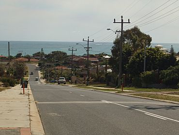
Quinns Road, heading towards the Indian Ocean
|
|||||||||||||||
| Established | 1962 | ||||||||||||||
| Postcode(s) | 6030 | ||||||||||||||
| Area | 3.84 km2 (1.5 sq mi) | ||||||||||||||
| Location | 38 km (24 mi) NNW of Perth | ||||||||||||||
| LGA(s) | City of Wanneroo | ||||||||||||||
| State electorate(s) | Burns Beach | ||||||||||||||
| Federal Division(s) | Pearce | ||||||||||||||
|
|||||||||||||||
Quinns Rocks is a cool coastal suburb in Perth, Western Australia. It's about 38 kilometers (24 miles) north of Perth's city center. This area is part of the City of Wanneroo, which is like its local council. Quinns Rocks officially started as a small town in 1962, and its main attraction has always been Quinns Beach.
Contents
Where is Quinns Rocks Located?
Quinns Rocks is on the coast, right next to the Indian Ocean. To the south, you'll find Mindarie (along Quinns Road). To the east are Merriwa and Butler (along Marmion Avenue). To the north, it borders Jindalee (along Hampshire Drive). The beautiful Quinns Beach stretches along the entire western side of the suburb.
The Story of Quinns Rocks
How Did Quinns Rocks Get its Name?
The name "Quinns Rocks" comes from some rocks in the ocean nearby. An early surveyor named James Cowle noticed them in 1867. He was continuing a survey started by Robert Quin, who was another surveyor. Robert Quin came to Western Australia in 1863 and worked as a surveyor for 22 years. Even though the name is spelled with a double "n" today, it's believed the rocks were named after him.
The area on the coast opposite these rocks was called Quinns Rocks by the Wanneroo Road Board back in 1925. Later, people also called it "Wanneroo Beach." There's also a story that it might be named after Mick Quinn, a sheep herder who worked in the area in the early 1900s.
How Quinns Rocks Grew Over Time
Early Days and Holiday Shacks
In 1930, the local council, the Wanneroo Road Board, took control of the beachfront. They allowed holidaymakers to set up small "boatsheds and campsites" for a small yearly fee. Early shack owners could only stay for 48 hours at a time without special permission. The first people to live there all the time arrived in 1942.
A caravan park was built in the south part of the beach in 1946. One of the first shack owners, Mr. L.G. Leppinus, had to move his shack three times because the beach was eroding (washing away). These early residents often dug their own water wells. By the 1950s, many more shacks lined the ocean front.
From Shacks to Suburb
Towards the end of the 1950s, the council decided to stop leasing the beachfront land. Shack owners were asked to remove their shacks. However, they were given the first chance to buy blocks of land right on the ocean front. These blocks cost about 400 pounds (which was about A$800 back then).
In 1958, a large piece of land was bought and divided into smaller blocks the next year. In March 1959, four new houses were approved for building. A big sale in June saw almost 300 blocks of land purchased. The area grew northward in the early 1960s. Quinns Rocks was officially declared a "townsite" on July 27, 1962. More areas were added in 1964 and 1972.
Old Quinns and New Areas
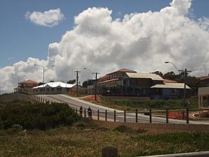
The original beachfront area, known as "Old Quinns," was developed up until the 1990s. This part of Quinns Rocks has rolling hills and roads, with power lines on wooden poles. It has fewer footpaths and many unique houses built in the 1960s and 1970s. Many homes here still use septic tanks for waste, but new sewer systems are planned for the future.
The Norfolk Estate was built in Quinns Rocks in the early 1990s, east of Tapping Way. This area looks different from "Old Quinns." It has underground power lines, streets that end in cul-de-sacs (dead ends), and modern bungalow-style houses.
The newest part of Quinns Rocks, simply called "Quinns Beach," was the last area to be developed. It borders Jindalee to the north.
Who Lives in Quinns Rocks?
In 2006, about 7,991 people lived in Quinns Rocks. Most residents (57.7%) were born in Australia. Many others came from English-speaking countries like the United Kingdom, South Africa, and New Zealand. About 19.7% of the population was born in the UK.
People in Quinns Rocks are generally younger than the national average, with a median age of 31. The average household income is also higher than the national average. Many residents identify as Christian, with Anglicanism being the largest group. There are two churches in southern Quinns: an Anglican Church of Australia and a Northside Baptist Church. About 26.7% of residents said they had no religion.
Things to Do and See in Quinns Rocks
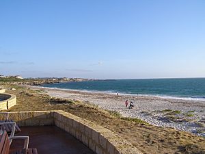
The biggest attraction in Quinns Rocks is Quinns Beach. It runs along the entire western side of the suburb. The beach has barbecue areas and playgrounds for families. There's also a special dog beach further north for dog walkers. You can find a beachside cafe and a shop selling drinks on Ocean Drive. The Quinns Mindarie Surf Lifesaving Club is also located here. They have been keeping the beach safe since 1982.
Quinns Rocks has more than ten large parks and reserves. Many of these parks have sports facilities for residents. You can find the Quinns Rocks Bowling Club, the Quinns Rocks Skate Park, and the Gumblossom Tennis Courts. The tennis courts are at Gumblossom Park, which is also home to the Gumblossom Community Centre. This center hosts many community events.
While Quinns Rocks is mostly residential, it has the Quinns Village Shopping Centre. This small shopping area in the south-east has an IGA supermarket for groceries. It also has a post office, a newsagent, a pharmacy, a shop selling drinks, and a petrol station.
Schools in Quinns Rocks
Quinns Rocks has two primary schools for students from Kindergarten to Year 6: Quinns Rocks Primary School and Quinns Beach Primary School. Quinns Rocks Primary is in the south, and Quinns Beach Primary is in the north.
Older students from Quinns Rocks usually attend high schools like Clarkson Community High School, Butler College, and Kinross High School. There are also other senior colleges close by, such as Mindarie Senior College, Peter Moyes Anglican Community School, and Quinns Baptist College. These schools are located near the border between Mindarie and Quinns Rocks.
Getting Around Quinns Rocks
You can reach Quinns Rocks by road using Marmion Avenue. This is a main road that connects the suburb to the rest of Perth to the south and to Yanchep in the north. Quinns Road used to connect the suburb directly to Wanneroo Road in the east. Now, the road east of Quinns Rocks has been changed and is called Hester Avenue.
There are three main roads within Quinns Rocks that help people get around. Quinns Road and Ocean Drive follow the southern and western edges of the suburb along the coast. Tapping Way generally divides the older part of Quinns from the Norfolk Estate. Santa Barbara Parade serves the eastern, inland part of the suburb.
Public Transport Options
The closest major public transport hub is Clarkson railway station. From here, you can catch trains to Joondalup and Perth's central business district. Two bus routes serve Quinns Rocks, running from Clarkson station to different parts of the suburb.
- 481 - Goes from Clarkson to southern Quinns Rocks, passing through Mindarie.
- 482 - Goes from Clarkson to northern Quinns Rocks, passing through Mindarie.
 | Charles R. Drew |
 | Benjamin Banneker |
 | Jane C. Wright |
 | Roger Arliner Young |


