Mindarie, Western Australia facts for kids
Quick facts for kids MindariePerth, Western Australia |
|||||||||||||||
|---|---|---|---|---|---|---|---|---|---|---|---|---|---|---|---|
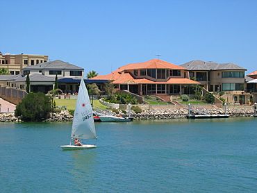
Mindarie Keys
|
|||||||||||||||
| Established | 1988 | ||||||||||||||
| Postcode(s) | 6030 | ||||||||||||||
| Area | 4.6 km2 (1.8 sq mi) | ||||||||||||||
| Location | 36 km (22 mi) from Perth | ||||||||||||||
| LGA(s) | City of Wanneroo | ||||||||||||||
| State electorate(s) | Mindarie | ||||||||||||||
| Federal Division(s) | Pearce | ||||||||||||||
|
|||||||||||||||
Mindarie is a coastal suburb located outside of Perth, Western Australia. It is about 36 kilometres (22 miles) north of Perth's main city area. Mindarie is part of the City of Wanneroo local government area.
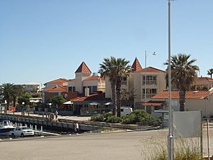
This area was first used for its limestone in the early 1900s. Mindarie officially became a suburb in 1988. This happened when the Mindarie Marina and a hotel were built. This marina is one of the biggest human-made marina resorts in Western Australia.
Today, Mindarie has many shops, restaurants, and schools. It is mostly a place where people live. There are also large natural areas like bushland reserves and parks. These areas help keep Mindarie's beautiful coastal dunes and natural environment safe. Mindarie was even a filming location for the kids' science fiction TV show Stormworld.
Contents
Exploring Mindarie's Location
Mindarie is bordered by Quinns Road, Marmion Avenue, and the Indian Ocean. To the east, you'll find the suburbs of Clarkson and Merriwa. Quinns Rocks is to the north. South of Mindarie is an empty area called Tamala Park.
Mindarie's Natural Beauty
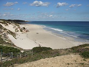
Many natural bushland areas and coastlines are protected in Mindarie's parks. These include Claytons Beach, Rosslare Park, Kinsale Park, and the North and South Mindarie Foreshores. The foreshore areas have large sand dunes called Quindalup dunes. They also have different types of plants from the Swan Coastal Plain. In 2011, work was done on the South Mindarie Foreshore to protect its dunes and plants.
Mindarie's Past: A Look at History
How Mindarie Got Its Name
Mindarie was named after Lake Mindarie, which is nearby in Carabooda. The name comes from the Noongar language. It means "stand by" or "green water." Alexander Forrest first wrote down this name in 1874. There is also a town called Mindarie in South Australia. That name comes from a Dieri word meaning "festival to invoke peace."
The area was first called "Clarkson" by the Shire of Wanneroo in 1979. The name Mindarie was given to the area next to it, to the east. In 1985, the names were switched. This happened because Smith Corporation, who built the Mindarie marina, asked for the change.
Early Days and Limestone Mining
The Mooro group of Noongar people knew Mindarie well. This included Waukolup Hill in nearby Tamala Park. However, no Mooro settlements were ever formally built here. A Mooro story about Mindarie tells of two boys who learned the law from tribal elders. They went to the Indian Ocean, drank the sea water, and were then turned into tuart trees.
After John Butler explored Wanneroo in 1835, the first European settler was Bernard Clarkson. He was a sheep farmer. In 1888, he got land leases of 13,000 acres. This land included what is now Mindarie, Clarkson, Quinns Rocks, and Merriwa. These leases were known as the Mindarie Pastoral Company. The Clarkson family used the land mainly for herding sheep for many years.
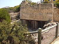
Other early settlers, Henry Cooper and his brothers, built two lime kilns in Mindarie in 1932. They had closed their quarries in Wembley. The Cooper family made and sold treated limestone in Perth and Fremantle. Their company was called the Quinns Rocks Lime Stone Company. They were among the first people to live permanently in the nearby Quinns Rocks town.
The kilns gave jobs to up to thirty-two workers. These workers lived in Mindarie in simple jarrah shacks. The kilns are seen as a sign of new industries starting during the tough economic times of the Great Depression. The Coopers stopped making lime in 1948 because they ran out of good quality limestone.
The kilns were repaired in 2001. Today, they are kept safe in the Coopers Park bushland reserve in Mindarie. They are important because of their clever, local design. Their location near the Indian Ocean was also unusual for lime-making in the Wanneroo area.
Building the Marina and Harbourside Village
After the lime kilns closed, John Clarkson sold the Mindarie Pastoral Company leases in 1952. The area stayed empty until 1981. Then, Smith Corporation bought 316 hectares of land for $5.5 million. In July 1984, the company announced plans for "Mindarie Keys." This was a $28 million marina and resort complex. It was designed by James Christou & Partners. They hoped it would be ready for the 1987 America's Cup in Fremantle.
That same year, there were also plans for a rubbish disposal plant in the area. This plant would handle waste from the Shire of Wanneroo, the City of Stirling, and the City of Perth. Both plans caused problems with people already living in nearby Quinns Rocks. They formed the Quinns Rocks Environment Group in June 1985 to oppose the plans. In 1988, Tamala Park was created from land that was part of southern Mindarie. This area was set aside for rubbish disposal and public open space.
The marina project faced environmental and planning concerns. It did not get final approval from the State Government until 1986. This was too late for it to be finished before the America's Cup began. Still, the first part of the Mindarie Keys development started in February 1988. This included the harbour, marina, and hotel. The first homes in southern and western Mindarie also began to sell.
However, during construction, Smith Corporation and its partners faced many problems. Costs went way over budget. They had guessed the land value was higher than it was. Also, not many homes were selling around the marina. This was due to an economic slowdown in the late 1980s. Cheaper homes were also being sold in nearby Quinns Rocks.
The Mindarie Keys marina was finally finished and opened to the public a year later. It cost $34 million in total. But because of the problems, Smith Corporation lost control of the project. Their lenders, Beneficial Finance, took over. They stopped further building to focus on selling the remaining homes. The project eventually went into receivership after Beneficial Finance's parent company, the State Bank of South Australia, failed in 1991.
Mindarie Keys Homes Development
Mindarie Keys Joint Venture bought the Mindarie Keys project in 1996. This group of developers and investors was led by Fini Group (now part of Mirvac). The project had been stuck for several years with no sales or building. The group made a plan for new homes in the northern part of Mindarie. They also planned to sell and develop older, unsold lots around the Harbourside Village.
This new area, also called "Mindarie Keys," was approved by the City of Wanneroo in 1998. It made Mindarie one of the most popular suburbs for home sales in Western Australia at that time.
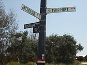
The area is bordered by Anchorage Drive South and Seaham Way to the west. Honiara Way is to the south. Rothesay Heights and Rochester Drive are to the south-east. This part of Mindarie is special because of its unique blue lampposts and street signs. These signs feature Mirvac's Mindarie Keys logo.
Catalina Development Plans
A new housing area called "Catalina" is being planned for Mindarie and Clarkson. Its proposed borders are south of Neerabup Road. This area is currently bushland that blends into Tamala Park. It stretches from the Joondalup railway line in eastern Clarkson to the South Mindarie Foreshore in western Mindarie. Even though this land is currently part of Mindarie and Clarkson, the developers, Satterley, want it to become its own suburb later.
Mindarie's People: Demographics
Mindarie has a special mix of people living there. At the 2006 census, 6,507 people lived in Mindarie. This was up from 4,675 people in 2001. The number of people is expected to keep growing, reaching 9,782 by 2026.
Only about 46% of Mindarie's residents were born in Australia. This is lower than the national average of about 71%. Mindarie has many people born in the United Kingdom, about 31%. This is much higher than the average for the surrounding coastal area and Australia (about 5%). The average age of people living in Mindarie was 36 years old. This is similar to the average age for Perth and Australia.
Most people in Mindarie (about 60%) follow Christianity. The only church in Mindarie is an Anglican Church of Australia in the north. About 31% of Mindarie residents said their religion was Anglicanism. Only 17.6% of the people said they had no religion.
The Australian Bureau of Statistics rated Mindarie as a higher socio-economic area in 2006. This means people living there generally have more advantages. The average income for an individual was $586 per week. The average household income was $1,522 per week. Both of these are much higher than the average for Perth. A larger number of Mindarie's residents (19.4%) worked as technicians and trades workers. This is more than the regional average (16.0%).
Things to Do and Places to Go in Mindarie
Mindarie is mostly a place where people live, but it has many facilities and things to do. There are two small shopping areas in the north and south of Mindarie. These include two petrol stations, various restaurants, and fast-food places like McDonald's and Red Rooster. There is also Basil's, an independent grocery store.
The Mindarie Keys Medical Centre in the south offers medical care, dental care, and physiotherapy. For bigger shopping needs, the large Ocean Keys Shopping Centre in Clarkson is right next to Mindarie.
Unlike the nearby Quinns Rocks coast, Mindarie's coastline is mostly taken up by the Mindarie Marina. This includes its large harbour and breakwater. The marina has been a popular place for tourists since it opened in the late 1980s. Along the boardwalk, the marina has a three-story hotel overlooking the harbour. It also has two restaurants, a small brewery, and The Boat, which is a pub and restaurant. The Boat provides most of Mindarie's entertainment and nightlife.
Just south of the marina's breakwater is Claytons Beach. This is a small beach without lifeguards. It is a popular spot for surfers. The empty bushland part of the beach, further south, goes through Tamala Park and into Burns Beach in the City of Joondalup.
Many parks and reserves are located all around Mindarie. Bellport Park has tennis courts. Lighthouse Park and Bellport Park both have large, working lighthouses. Along with the lime kilns in Coopers Park, these are important local landmarks.
Telephone services are provided by the Mindarie & Quinns Rocks telephone exchanges. The Mindarie exchange is in the south-east of Mindarie, on Rothesay Heights.
Learning in Mindarie: Schools
Mindarie has one primary school for students from Kindergarten to Year 6, called Mindarie Primary School. This school serves the whole suburb. Older students in Mindarie usually go to Clarkson Community High School.
Students can also attend Mindarie Senior College, which was built in the north of Mindarie in 2003. This college is for Years 11-12 only. It mainly takes students who have finished Years 7-10 at nearby Kinross College.
Students in Mindarie also have the choice of private Christian schools. There are two in the suburb: Peter Moyes Anglican Community School (started in 2000) and Quinns Baptist College (started in 1996). Both schools accept students from Kindergarten to Year 12. They are located next to Mindarie Senior College along Mindarie's northern border.
Getting Around Mindarie: Transport
Mindarie is connected to the rest of Perth by Hester Avenue and Neerabup Road. Both of these roads connect to the Mitchell Freeway and Wanneroo Road a short drive to the east. The main road, Marmion Avenue, also runs next to Mindarie's border. It connects to Yanchep in the far north.
Anchorage Drive South, Rothesay Heights, and Bellport Parade are the main roads within Mindarie. Anchorage Drive was first planned as a single main road that would loop through the suburb. However, the Mindarie Keys Joint Venture decided not to finish the road. This was because it would have blocked inland residents. Instead, 700 metres of the planned road were turned into part of Lighthouse Park. Even though this landscaped section is still officially a road reserve, studies in 2001 showed there was no need to complete the road.
Public Transport Options
Mindarie has bus routes 481 and 482 that go to Clarkson railway station. This station is a hub for more bus and train connections to the nearby city of Joondalup and the rest of Perth. On weekends, a special route of the 481 bus also goes directly to the marina.
- 481 - Clarkson to Quinns Rocks (south) via Mindarie
- 482 - Clarkson to Quinns Rocks (north) via Mindarie
 | William L. Dawson |
 | W. E. B. Du Bois |
 | Harry Belafonte |


