Merriwa, Western Australia facts for kids
Quick facts for kids MerriwaPerth, Western Australia |
|||||||||||||||
|---|---|---|---|---|---|---|---|---|---|---|---|---|---|---|---|

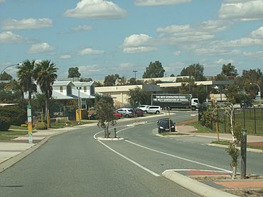
Baltimore Parade and the Merriwa Plaza
|
|||||||||||||||
| Established | 1980s | ||||||||||||||
| Postcode(s) | 6030 | ||||||||||||||
| Area | 2.3 km2 (0.9 sq mi) | ||||||||||||||
| Location | 36 km (22 mi) from Perth City | ||||||||||||||
| LGA(s) | City of Wanneroo | ||||||||||||||
| State electorate(s) | Butler | ||||||||||||||
| Federal Division(s) | Pearce | ||||||||||||||
|
|||||||||||||||
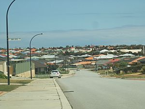
Merriwa is a coastal suburb located north of Perth, Western Australia. It is about 36 kilometers (22 miles) north of Perth's city center. Merriwa is part of the City of Wanneroo local government area. It is mainly a residential area, meaning it's where people live. You can also find two special villages here for retired members of the Royal Australian Air Force (RAAF).
Contents
History of Merriwa
How Merriwa Got Its Name
The name "Hester" was first chosen for this area in 1980. It was named after Thomas Hester, one of the first landowners nearby. However, Australia Post didn't approve this name. This was because there was already a town called Hester in another part of Western Australia.
So, a new name was needed. "Merriwa" was then suggested and approved in the same year. "Merriwa" is an Aboriginal word that means "a good place." The original name, Hester, still lives on in Hester Avenue. This is a main road that forms the southern border of the suburb.
How Merriwa Was Built Up
Before the late 1980s, Merriwa was mostly empty bushland. There were no major buildings or features, just Quinns Road. This road connected the nearby town of Quinns Rocks to Wanneroo Road.
The first part of Merriwa to be developed was the Quinns Beach Estate. This happened in the late 1980s and early 1990s. Many early residents faced challenges. There weren't many shops or services, and some roads and footpaths were not well built. There were also not many streetlights, and the area felt isolated. This led people to form the Merriwa Development Committee. Their goal was to ask the local council to fix these problems.
In the mid-1990s, another area called Carnegie Private Estate was built. In 1998, Merriwa was divided into two parts. The eastern half, including the Carnegie Estate, became a new suburb called Ridgewood.
Later, in the early 2000s, the Seagrove Estate was built in the northern part of Merriwa. This new development was planned to make sure residents had enough services and parks. Merriwa is also home to two RAAF retirement villages. These are called Merriwa Estate and Cambrai Village.
Geography of Merriwa
Merriwa is surrounded by other suburbs. To the north is Butler, and to the east is Ridgewood. Quinns Rocks and Mindarie are to the west. Clarkson is located to the south.
Merriwa used to be much larger. It extended further east towards the Joondalup railway line. However, it was split in 1998 to create the new suburb of Ridgewood. Merriwa is also quite close to the coast. It is only about 2 kilometers (1.2 miles) from Quinns Beach and the Indian Ocean.
People Living in Merriwa
In 2006, Merriwa had a population of 5,220 people. This was an increase from 2001. Most people in Merriwa (64.2%) were born in Australia. This is a bit lower than the national average for Australia. However, it's higher than some nearby suburbs. About 14.2% of Merriwa's residents were born in Britain.
The average age of people living in Merriwa is 33 years old. This is younger than the average age for all of Australia, which is 37.
Many residents in Merriwa identify as Christian (48.6%). However, a large number of people (26.8%) also said they had no religion. The most common Christian group was Anglicanism (23.3%). There is one Pentecostal church in Merriwa called One Church.
Things to Do and Places to Go in Merriwa
Merriwa is mostly a place where people live. However, it does have some shops and retail stores. For bigger shopping trips or other services, residents often go to Clarkson or the larger city of Joondalup.
The Merriwa Plaza is a shopping area within the Quinns Beach Estate. It has a large supermarket and several smaller shops and take-away restaurants.
There are six large parks spread throughout Merriwa. Many of these parks have extra sports facilities. Addison Park has clubrooms and a hall for events. Dalvik Park is next to the Alkimos Baptist College campus. The Jenolan Way Community Centre is also nearby. It has rooms for functions and offices.
The Brighton Beach Medical Centre in northern Merriwa provides healthcare services. Close by is a St John ambulance station. This station opened in 2008 and is open 24 hours a day. It serves Merriwa and all the surrounding suburbs.
Schools in Merriwa
Merriwa has one primary school called Merriwa Primary School. It teaches children from Kindergarten to Year 6. On the same campus is the Merriwa Education Support Centre. This center specializes in teaching children with intellectual disabilities. Older students from Merriwa, from Year 7 onwards, usually attend Clarkson Community High School.
There is also a private school located near Dalvik Park. This school was known as Kingsway Christian College until it closed in 2007. The campus was empty for three years. Then, it reopened as Alkimos Baptist College. This is a private Baptist primary school for children from Kindergarten to Year 8. The school plans to move to a new building in Alkimos in the future.
Getting Around Merriwa
Roads in Merriwa
Merriwa is connected to Perth by two main roads: Marmion Avenue and Connolly Drive. These roads run parallel to each other along Merriwa's western and eastern edges. Hester Avenue, on the southern side of Merriwa, connects directly to the Mitchell Freeway and Wanneroo Road to the east. Lukin Drive runs along the northern border. This road will connect to the Mitchell Freeway when its extension is finished.
Baltimore Parade is a main road that runs through the middle of Merriwa from north to south. It connects the whole suburb. This road was changed during the development of the Seagrove Estate. It now exits north onto Lukin Drive. The old part of the road was renamed Hughie Edwards Drive.
Public Transport in Merriwa
Merriwa is located between two train stations: Clarkson Station to the south and Butler Station to the north. Both stations are about the same distance away. These stations provide train links to the Joondalup city center and then to the Perth city center via the Joondalup line.
Merriwa is also served by three bus routes:
- 483 – This bus goes from Clarkson Station to Alkimos Primary, passing through Merriwa.
- 482 – This bus travels from Clarkson Station to Butler Station, going via Quinns Rocks.
- 480 – This is a faster bus service that goes from Clarkson Station to Butler Station via Marmion Avenue.
 | Ernest Everett Just |
 | Mary Jackson |
 | Emmett Chappelle |
 | Marie Maynard Daly |


