Burns Beach, Western Australia facts for kids
Quick facts for kids Burns BeachPerth, Western Australia |
|||||||||||||||
|---|---|---|---|---|---|---|---|---|---|---|---|---|---|---|---|

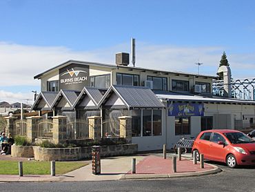
The Burns Beach Cafe and Restaurant
|
|||||||||||||||
| Established | 1920s | ||||||||||||||
| Postcode(s) | 6028 | ||||||||||||||
| Area | 3.3 km2 (1.3 sq mi) | ||||||||||||||
| Location | 32 km (20 mi) NW of Perth central business district | ||||||||||||||
| LGA(s) | City of Joondalup | ||||||||||||||
| State electorate(s) | Burns Beach | ||||||||||||||
| Federal Division(s) | Moore | ||||||||||||||
|
|||||||||||||||
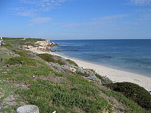
Burns Beach is a suburb of Perth, Western Australia. It is located about 34 kilometers (21 miles) north of Perth's main city area. Burns Beach is at the northern edge of the City of Joondalup. Even though Perth has grown a lot, Burns Beach still feels like a small, friendly coastal village. The beach is very popular with people who enjoy hang gliding.
Contents
Discovering Burns Beach's Past
The land where Burns Beach is today was first owned by a company called the Midland Railway Company. In 1908, about 50 local people asked for a special area. They wanted a 20-hectare (50-acre) spot for camping and a health resort. The Wanneroo Road Board, which later became the City of Wanneroo, helped them get this land.
By the 1920s, many locals were using the area. They called it "Burns Beach" after a farmer who kept his sheep there. For a long time, you could only reach Burns Beach by a rough track or by boat. It was a small coastal village where people mostly worked in tourism and fishing. After World War II, a proper road connected it to Wanneroo Road.
In the 1990s, Perth started growing northwards. New suburbs like Currambine and Kinross were built. This growth reached Burns Beach as Joondalup became a bigger town nearby.
Life in Burns Beach Today
Burns Beach has kept its special village feel, even though it's not as isolated as it used to be. The original caravan park is still open for visitors. Burns Beach is also the start of a beautiful coastal nature walk. This path stretches all the way to Fremantle.
The suburb has a cafe and restaurant with outdoor seating. There's also a picnic area with barbecues and toilets. Many people love to park their cars facing the ocean. It's a great spot to watch the sunset in summer or the big waves in winter.
Where is Burns Beach?
Burns Beach is next to the ocean on its west side. Marmion Avenue is to its east, and Burns Beach Road is to the south. To the north, there's a natural bushland area called Tamala Park. This bushland acts like a buffer, separating Burns Beach and Kinross from the towns of Mindarie and Clarkson.
In 2001, a survey showed that 225 people lived in Burns Beach. They lived in 90 homes. The average age of residents was 39 years old. A caravan park nearby also had about 90 residents. The homes in Burns Beach are a mix of older holiday houses and newer ones built after World War II.
Learning in Burns Beach
A new primary school, Burns Beach Primary School, opened in February 2022. Other primary schools are in Beaumaris (Ocean Reef), Currambine, and Kinross. For high school, students in Burns Beach can go to Ocean Reef Senior High School or Clarkson Community High School.
Getting Around Burns Beach
Burns Beach is served by Transperth buses. You can catch the 470 and 471 bus routes from Joondalup. These buses are run by a company called Swan Transit.
 | Chris Smalls |
 | Fred Hampton |
 | Ralph Abernathy |


