
Watermans Bay, Western Australia facts for kids
Quick facts for kids Watermans BayPerth, Western Australia |
|||||||||||||||
|---|---|---|---|---|---|---|---|---|---|---|---|---|---|---|---|

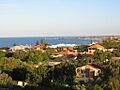
View towards the ocean at sunset from Watermans Bay
|
|||||||||||||||
| Established | 1918 | ||||||||||||||
| Postcode(s) | 6020 | ||||||||||||||
| Area | 1.7 km2 (0.7 sq mi) | ||||||||||||||
| Location | 18 km (11 mi) NW of Perth | ||||||||||||||
| LGA(s) | City of Stirling | ||||||||||||||
| State electorate(s) | Carine | ||||||||||||||
| Federal Division(s) | Moore | ||||||||||||||
|
|||||||||||||||
Watermans Bay is a pretty coastal suburb located north of Perth, the capital city of Western Australia. It's part of the City of Stirling, which is its local council area.
Contents
A Look Back: Watermans Bay History
Watermans Bay was once part of a huge property called the Hamersley Estate. This estate also included areas now known as Carine and North Beach. The Hamersley family, who owned this land, came to Australia in 1837.
In 1865, the Hamersleys built a summer house called "The Castle" near Watermans Bay. Their large family and other important people from Perth would gather there for holidays. You can still see their family's influence today, as many street names in Watermans Bay are named after Hamersley family members.
Early Days and First Settlers
Before it was a suburb, this area was a timber reserve. In the 1860s, people who raised farm animals, called pastoralists, started settling here. It was a useful stop for cattle drovers moving animals between Dongara and Fremantle.
After gold was discovered in the 1890s, Afghan camel drivers were often seen in the area. They used camels to transport goods, especially to the goldfields.
How Watermans Bay Got Its Name
In 1908, a businessman and fisherman named Alfred Waterman built the first house in what is now Watermans Bay. He called his house "Zephyr." The beach next to his house became known as Watermans Bay, and it was a popular spot for fishing.
Back then, getting to the area was tricky. There was a wooden road built by convicts, which later became Wanneroo Road. From there, you had to follow a limestone track to North Beach. Over time, more tracks were made through the bush.
Growing into a Suburb
In 1918, the land was divided into smaller blocks as part of the Mt Flora Estates. At first, most buildings were just holiday shacks. After World War II, the area grew quickly.
By 1954, Watermans Bay was officially recognized as a postal district. By 1961, almost all of the suburb had been built and settled.
Star Swamp Bushland Reserve
Star Swamp Bushland Reserve is a large natural area. It covers about half of Watermans Bay and North Beach. No one knows for sure how it got its name, but it was first mentioned in 1868.
This area has a long history as a camping spot for the Noongar people. They found fresh water, plenty of native foods, and seafood there. You can still find signs of their presence.
In 1987, the government protected 96 hectares of Star Swamp. Money from the Bicentennial program helped create the Star Swamp Heritage Trail. This trail lets visitors explore the reserve and learn about its history.
Watermans Bay Location and Homes
Watermans Bay is bordered by Beach Road to the north and West Coast Drive and the ocean to the west. Star Swamp is to the east of Hope Street and makes up more than half of the suburb's land.
Reid Highway ends at the southeast corner, connecting the suburb to the Mitchell Freeway and the Perth central business district.
In 2006, about 1,195 people lived in Watermans Bay. The homes here vary a lot, from older timber and fibro houses to modern two-story brick homes. Because it's a small, desirable area, Watermans Bay is one of the most expensive northern suburbs in Perth.
Local Facilities and Attractions
Watermans Bay is mainly a place where people live. For shopping, residents go to the North Beach Shopping Centre. This center has a gym, a cafe, a supermarket, and other shops.
There are also shops in nearby Marmion, North Beach, and Duncraig. For bigger shopping trips, Karrinyup Shopping Centre is close by.
Watermans Bay doesn't have its own schools. However, Marmion Primary School is just north of the suburb, and North Beach Primary School is just south.
Marine Research and Museum
The WA Marine Research Laboratories are located on the beach near Elvire Street. These labs used to be the main office for the research part of the WA Department of Fisheries. In 2005, they moved to Hillarys. Now, this site is home to the department's International Operations Branch.
On the southern edge of the suburb, also on Elvire Street, is the Mount Flora Regional Museum. This building was originally a water tower, built in 1936. It was the highest point in the suburb and helped provide water to the surrounding areas.
The water tower stopped being used in the 1970s. In May 1986, it was turned into a museum and a lookout point. It now shares the history of the region and is home to the North Suburban Historical Society.
Getting Around Watermans Bay
Watermans Bay is served by the 423 bus route. This bus travels between Warwick and Stirling train stations. It is operated by Swan Transit.
Bus Routes
- 423 Stirling Station to Warwick Station – travels along Flora Terrace and Beach Road.
Images for kids
-
View over Watermans Bay from Mount Flora Lookout

