
Martensville facts for kids
Quick facts for kids
Martensville
|
||
|---|---|---|
|
City
|
||
| City of Martensville | ||

Martensville's business district
Centennial Drive (2009) |
||
|
|
||

Martensville
Location in Corman Park No. 344

Martensville
Location in Saskatchewan
|
||
| Country | Canada | |
| Province | Saskatchewan | |
| Metropolitan area | Saskatoon | |
| Rural municipality | Corman Park | |
| Founded | 1939 | |
| Incorporated (village) | 1966 | |
| Incorporated (town) | 1969 | |
| Incorporated (city) | 2009 | |
| Area | ||
| • Total | 13.56 km2 (5.24 sq mi) | |
| Population
(2021)
|
||
| • Total | 10,549 | |
| • Density | 1,421.2/km2 (3,681/sq mi) | |
| Time zone | UTC-6 (CST) | |
| Postal code |
S0K 2T0 & S0K 5B0 S0K 2T1 S0K 2T2 S0K 0A2
|
|
| Area code(s) | 306, 639 | |
| Highway | Highway 12 | |
Martensville is a city in Saskatchewan, Canada. It's located just 8 kilometres (5.0 mi) north of Saskatoon. It's also 10 kilometres (6.2 mi) west of Warman. Martensville is often called a "bedroom community" because many people who work in Saskatoon live here.
The city is surrounded by the Rural Municipality of Corman Park No. 344. Martensville has its own small airport, the Saskatoon/Richter Field Aerodrome. It's also close to Saskatoon's larger Saskatoon John G. Diefenbaker International Airport.
Contents
Martensville's History
In 1939, two people named Isaac and Dave Martens bought land north of Saskatoon. They sold small parts of this land to others. This is how the community of Martensville began. Many Mennonites who worked in Saskatoon chose to live here. This helped them stay connected to the large Mennonite community nearby.
Martensville officially became a village in 1966. Just three years later, in 1969, it became a town. In 1976, the town got sewer and water services. This helped Martensville grow much faster. Finally, in 2009, Martensville became a city.
Martensville's Population and People
In 2021, Martensville had a population of 10,549 people. This was a growth of about 9.3% since 2016. The city has a land area of 13.56 km2 (5.24 sq mi). This means about 777.9/km2 (2,015/sq mi) people live in each square kilometer.
The average age of people in Martensville in 2021 was 33.6 years old. This shows it's a city with many young families and people.
Who Lives in Martensville?
Martensville is home to people from many different backgrounds. Here's a look at the main groups:
| Panethnic group | 2021 | 2016 | 2011 | 2006 | 2001 | |||||
|---|---|---|---|---|---|---|---|---|---|---|
| Pop. | % | Pop. | % | Pop. | % | Pop. | % | Pop. | % | |
| European | 8,765 | 83.28% | 8,415 | 87.25% | 7,165 | 92.87% | 4,735 | 95.37% | 4,095 | 93.81% |
| Indigenous | 1,185 | 11.26% | 880 | 9.12% | 420 | 5.44% | 225 | 4.53% | 245 | 5.61% |
| Southeast Asian | 225 | 2.14% | 175 | 1.81% | 20 | 0.26% | 0 | 0% | 25 | 0.57% |
| South Asian | 100 | 0.95% | 40 | 0.41% | 20 | 0.26% | 0 | 0% | 0 | 0% |
| African | 100 | 0.95% | 40 | 0.41% | 0 | 0% | 10 | 0.2% | 0 | 0% |
| Latin American | 65 | 0.62% | 40 | 0.41% | 0 | 0% | 0 | 0% | 0 | 0% |
| East Asian | 40 | 0.38% | 40 | 0.41% | 0 | 0% | 0 | 0% | 0 | 0% |
| Middle Eastern | 0 | 0% | 15 | 0.16% | 0 | 0% | 0 | 0% | 0 | 0% |
| Other/multiracial | 35 | 0.33% | 0 | 0% | 30 | 0.39% | 0 | 0% | 10 | 0.23% |
| Total responses | 10,525 | 99.77% | 9,645 | 99.9% | 7,715 | 99.99% | 4,965 | 99.94% | 4,365 | 100% |
| Total population | 10,549 | 100% | 9,655 | 100% | 7,716 | 100% | 4,968 | 100% | 4,365 | 100% |
| Note: Totals greater than 100% due to multiple origin responses | ||||||||||
Martensville's Geography and Climate
Martensville is located between the North Saskatchewan River and South Saskatchewan River. It sits about 600 meters (2,000 ft) to 700 meters (2,300 ft) above sea level. The area is known for its aspen parkland ecoregion. This means you'll see patches of aspen trees mixed with open fields.
Martensville is very close to other cities. It's only 20 kilometers (12 mi) north of Saskatoon. It's also 14 kilometers (8.7 mi) southwest of the Clarkboro Ferry. The distance between Martensville and Warman is only 10 km. This makes them the closest two cities in Saskatchewan.

Martensville has a dry prairie and savanna climate. It experiences four distinct seasons. Summers are warm, and winters are very cold. Average temperatures range from about -17°C in January to 18°C in July. The area is quite dry, with most rain falling in the summer.
The land around Martensville is mostly sandy plains. These were formed by ancient glacial lakes. There are no large natural lakes here because the sandy soil drains water away quickly. The small lakes you see are leftover from old river channels.
Education in Martensville
Martensville got its first school in 1953. Today, the city has several schools for students. There are three public elementary schools and one Catholic elementary school. There is also one high school. All these schools are part of the Prairie Spirit School Division.
Valley Manor Elementary School is on the south side of Martensville. Venture Heights Elementary School and Martensville High School are on the north side. Each of these schools has over 700 students. In 2017, a new public school called Lake Vista Public School opened. It can hold 450 students and is for grades K-8.
In 2010, Catholic families in Martensville created their own school division. This group later joined with Greater Saskatoon Catholic Schools. In 2015, it was announced that their new elementary school would be named Holy Mary Catholic School. It opened in 2017.
Fun Things to Do in Martensville
Martensville has seven lakes connected by canals. These lakes were made to hold water, but they are also great for fun activities all year. You can go perch fishing, canoeing, and ice skating on them.
The city also has an outdoor swimming pool that opened in 2010. It has a large pool, a shallow pool for little kids, and a toddler pool. There are also four waterslides and fun spray features. It's right next to the community center.
Wanuskewin Heritage Park is a special historical site. It's about 5 miles (8.0 km) from Martensville. The Sutherland Bird Sanctuary is also nearby, about 10 miles (16 km) away.
Arts and Culture in Martensville
Martensville hosts its annual Buster Days festival every June. This is a 3-day festival with a parade, dances, and softball games. Since 2005, it has also included a volleyball tournament. Before 2005, there were amusement rides, games, and food stalls.
Because Martensville is so close to Saskatoon, residents can easily enjoy events there. This includes shows and games at the SaskTel Centre.
Sports in Martensville
Martensville has many places for sports and activities. These include:
- A kart racing track (Saskatoon Kart Racers)
- The North Ridge Centennial Centre
- Chrome Dome Park (for baseball and soccer)
- Kinsmen Park (for tennis, skateboarding, walking, and tobogganing)
- North Hills Park
- The Sport Centre (with a hockey rink for the Marauders team and a curling rink)
- The outdoor aquatic facility (swimming pool)
The SaskTel Curling Stadium Martensville opened in 2021. It allows live broadcasts of curling games. The Martensville Athletic Pavilion is a large indoor sports facility. It has court spaces, multi-purpose rooms, a running track, and a fitness gym.
Martensville is home to several sports teams:
- The Martensville Mustangs (baseball team)
- The Martensville Maddogs (football team)
- The Martensville Royals (high school football team)
The city used to have a golf course and a bowling alley. These were removed in 2008 to make way for new homes and the public swimming pool.
Transportation and Services
Martensville is connected by major roads. Highway 12 goes through Martensville. This highway connects to Blaine Lake.
The city is about 9 miles (14 km) from the Saskatoon John G. Diefenbaker International Airport. This makes travel easy for residents.
Martensville and Warman are the only cities in Saskatchewan without their own full hospital. Residents use the Saskatoon City Hospital for medical care.
In 2011, Martensville got its first traffic lights at Centennial Drive and Main Street. More traffic lights were added in 2016 and 2018 as the city grew.
Media in Martensville
Martensville has its own weekly newspaper called The Martensville Messenger. It was started in 2007 by Christine Lyon. Another newspaper, the Clark's Crossing Gazette, also delivers to Martensville and Warman.
Martensville residents also get news and entertainment from Saskatoon's newspapers, radio stations, and TV channels. Martensville is one of only two cities in Saskatchewan that doesn't have its own local radio station.
Images for kids
-
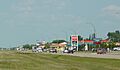
Martensville's business district on Centennial Drive (2009)
-
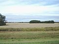
Patches of Aspen trees surrounded by wheat fields in the summer.
