Maryland City, Maryland facts for kids
Quick facts for kids
Maryland City, Maryland
|
|
|---|---|

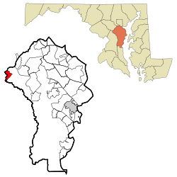
Location within Anne Arundel County
|
|
| Country | |
| State | |
| County | |
| Area | |
| • Total | 7.71 sq mi (19.98 km2) |
| • Land | 7.71 sq mi (19.98 km2) |
| • Water | 0.00 sq mi (0.00 km2) |
| Elevation | 207 ft (63 m) |
| Population
(2020)
|
|
| • Total | 19,153 |
| • Density | 2,483.21/sq mi (958.72/km2) |
| Time zone | UTC−05:00 (Eastern) |
| • Summer (DST) | UTC−04:00 (Eastern) |
| ZIP Code |
20724
|
| Area code(s) | 301 and 240 |
| FIPS code | 24-51075 |
| GNIS feature ID | 0590752 |
Maryland City is a special kind of community called a census-designated place (CDP). It is located in Anne Arundel County, Maryland, in the United States. In 2020, about 19,153 people lived there.
Maryland City is found just east of Laurel. It is very close to the border with Prince George's County. Even though it's in Anne Arundel County, it shares a ZIP Code with Laurel.
This area has older houses built close together. It is also right next to the Fort Meade army base. A newer neighborhood called Russett was built in the mid-1990s. This area is also part of the Maryland City CDP.
Contents
Community Services
Maryland City has its own fire department. It is called the Maryland City Volunteer Fire Department. This department is part of the larger Anne Arundel County Fire Department.
Their main station, Station 27, is located on Laurel Fort Meade Road. It has firefighters working 24 hours a day. These firefighters are also helped by many volunteers.
A Look at History
Maryland City was planned and built by a company called Maryland City Corp. The owner was a developer named Harvey Kayne. In 1960, they bought 1,200 acres of land for $3 million. This land was in eastern Laurel, Maryland.
The idea was to build homes that were affordable. Instead of owning the land, people would pay a "ground-rent."
Where is Maryland City?
Maryland City is in the very western part of Anne Arundel County. It is bordered by several other places. To the west is Laurel, in Prince George's County. To the north is Scaggsville in Howard County. Jessup is to the northeast. Fort Meade is to the east and south.
The Baltimore–Washington Parkway (Maryland Route 295) goes through Maryland City. This road can take you to Washington (about 19 miles southwest). It also goes to Baltimore (about 18 miles northeast). You can get to Maryland City from the parkway using Maryland Route 198. Another road, Maryland Route 32, forms the northeast edge of the area.
Maryland City covers an area of about 20 square kilometers (7.7 square miles). All of this area is land.
Population and People
| Historical population | |||
|---|---|---|---|
| Census | Pop. | %± | |
| 2010 | 16,093 | — | |
| 2020 | 19,153 | 19.0% | |
| U.S. Decennial Census | |||
Population in 2010
In 2010, the total population of Maryland City was 16,093 people. Here's a quick look at the different groups of people living there:
| Population by Race in Maryland City, Maryland (2010) | ||
| Race | Population | % of Total |
|---|---|---|
| Total | 16,093 | 100 |
| African American | 6,772 | 42 |
| White | 6,272 | 38 |
| Hispanic | 2,151 | 13 |
| Asian | 1,333 | 8 |
| Other | 1,005 | 6 |
| Two or More Races | 663 | 4 |
See also
 For more information in Spanish: Maryland City para niños
 | Misty Copeland |
 | Raven Wilkinson |
 | Debra Austin |
 | Aesha Ash |


