Massereene Lower facts for kids
Quick facts for kids
Massereene Lower
Mása Ríona Íochtarach (Irish)
|
|
|---|---|

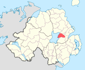
Location of Massereene Lower, County Antrim, Northern Ireland.
|
|
| Sovereign state | United Kingdom |
| Country | Northern Ireland |
| County | Antrim |
Massereene Lower is a special area in County Antrim, Northern Ireland. It's known as a barony, which is like an old-fashioned district or region.
This area is located right next to Lough Neagh on its western side. It also shares borders with four other baronies. To the south, you'll find Massereene Upper. To the east is Belfast Upper, and to the north is Antrim Upper. Finally, Toome Upper is located to the north-west.
Contents
Towns and Villages
Massereene Lower is home to several interesting towns and villages. These are places where people live and work.
Main Towns
- Muckamore
Other Population Centres
- Aldergrove
- Diamond
- Killead
- Loanends
- Nutt's Corner
Historical Church Areas
This barony also includes areas known as civil parishes. These are traditional divisions, often linked to old church boundaries.
- Grange of Muckamore
- Killead
Ancient Ringforts
Massereene Lower is a very important place for history buffs. It has the largest number of ringforts in all of Ireland.
A ringfort is an ancient circular fort. It was usually made of earth and wood. These forts were built a very long time ago. In Massereene Lower, you can find about three ringforts for every square kilometre. This shows how important this area was in the past!

