Matagorda Island facts for kids

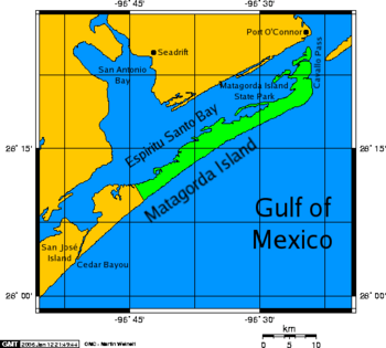
Matagorda Island and San Antonio Bay
|
|
| Geography | |
|---|---|
| Location | Gulf of Mexico |
| Coordinates | 28°13′38″N 96°38′25″W / 28.22722°N 96.64028°W |
| Archipelago | Texas barrier islands |
| Area | 60.7 sq mi (157 km2) |
| Length | 38 mi (61 km) |
| Administration | |
|
United States
|
|
| State | Texas |
| County | Calhoun County |
Matagorda Island is a long, narrow island along the Texas coast. Its name comes from Spanish words meaning "thick bush." This island is about 38 miles (61 km) long. It is located about 7 miles (11 km) south of Port O'Connor.
Matagorda Island is a barrier island. This means it is a long, narrow island that protects the mainland from ocean storms. The Gulf of Mexico is to its east and south. Espiritu Santo Bay is to its west and north. The island was once the home of the Karankawa people.
Matagorda Island is separated from San José Island by Cedar Bayou. It is separated from the Matagorda Peninsula by Pass Cavallo. You can only reach the island by boat. It covers a land area of about 60.7 square miles (157 km²).
Matagorda Island National Wildlife Refuge
Most of Matagorda Island is a special place for nature. It is called the Matagorda Island National Wildlife Refuge and State Natural Area. This area is managed by the Texas Parks and Wildlife Department and the United States Fish and Wildlife Service. They work to protect the animals and plants that live there.
Island History
The land that is now Matagorda Island State Park was bought by the government in 1940. It was used as a training area during World War II.
Matagorda Island has also appeared in books. It was a "survival location" in Day by Day Armageddon by J.L. Bourne. The island is also a main setting in the book Powersat by Ben Bova. A book called A Texas cowboy, or, Fifteen years on the hurricane deck of a Spanish pony by Charles A. Siringo describes life on the island in the late 1800s.
Climate
Matagorda Island has a warm and humid climate. Summers are hot and wet. Winters are usually mild or cool. This type of weather is known as a humid subtropical climate. On climate maps, it is often shown as "Cfa."
See also
 In Spanish: Isla Matagorda para niños


