Matatoki facts for kids
Quick facts for kids
Matatoki
|
|
|---|---|

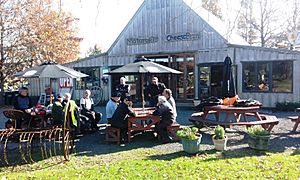
Lunch at the Matatoki Cheese Barn
|
|
| Country | New Zealand |
| Region | Waikato |
| District | Thames-Coromandel District |
| Ward | Thames ward |
| Community Board | Thames Community |
| Electorates |
|
Matatoki is a small place in New Zealand, located on the Hauraki Plains. It's found along State Highway 26, southeast of Thames and north of Paeroa. A stream called Matatoki Stream flows from the Coromandel Range through the area and into the Waihou River.
A large sawmill nearby, called Kopu sawmill, closed down in 2008. This meant 145 people lost their jobs.
Contents
A Glimpse into Matatoki's Past
Long ago, the eastern side of the Waihou River near Matatoki was home to many Hauraki Māori villages called pā. Some of these important pā were Oruarangi and Paterangi. People likely started living in these villages around the 1300s.
Between the 1930s and 1960s, Oruarangi pā became a very important place for archaeologists. They found many old Māori artifacts there. These discoveries helped us learn a lot about early Māori life.
Who Lives in Matatoki?
The Matatoki-Puriri area covers about 161 square kilometers. As of 2023, about 1,190 people live here.
In 2018, the population of Matatoki-Puriri was 1,059 people. This was a small increase from 2013. There were 396 households in the area.
Most people living in Matatoki are of European descent (93.2%). About 17% are Māori. A smaller number of people are from Pacific Islands or Asia. About 8.5% of the people living here were born outside New Zealand.
When asked about religion, most people (59.5%) said they had no religion. About 28% were Christian.
Learning in Matatoki
Matatoki School is a school for both boys and girls. It teaches students from Year 1 to Year 8 (which is about ages 5 to 13). As of February 2024. , the school has 80 students. The school first opened its doors in 1920.
Matatoki's Railway History
Matatoki used to have its own railway station. It was located just south of the village. The station was part of the Thames Branch railway line. This line connected Thames to other towns.
Building the railway line through Matatoki was a big job. Workers made good progress in the 1880s. The section of the line that went through Matatoki was finished in May 1887. The whole Thames to Paeroa section of the railway opened on December 19, 1898.
Matatoki station was a "flag station." This meant trains would only stop if someone waved a flag or if passengers wanted to get off. The station had a small shelter and a platform. Later, it also had a special track for trains to pass each other. There was also a loading area for a local quarry to load crushed rock onto trains.
Passenger trains stopped running to Matatoki on March 28, 1951. Freight trains continued for a while, but the station closed and reopened a few times. The last commercial train used the Thames branch line in June 1991. The line officially closed in March 1995.
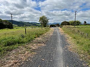
Today, the old railway line through Matatoki is no longer used by trains. Instead, it's part of the Hauraki Rail Trail. This is a popular path for walking and cycling.
| Preceding station | Following station | |||
|---|---|---|---|---|
| Puriri Line closed, station closed 3.66 km (2.27 mi) |
Thames Branch New Zealand Railways Department |
Kopu Line closed, station closed 4.05 km (2.52 mi) |
||
 | Claudette Colvin |
 | Myrlie Evers-Williams |
 | Alberta Odell Jones |


