Maytown, Alabama facts for kids
Quick facts for kids
Maytown, Alabama
|
|
|---|---|

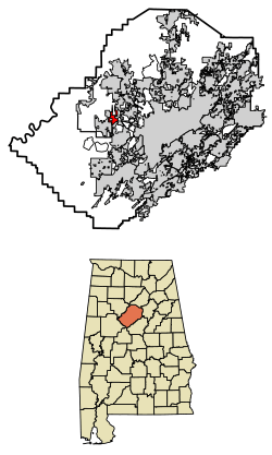
Location of Maytown in Jefferson County, Alabama.
|
|
| Country | United States |
| State | Alabama |
| County | Jefferson |
| Area | |
| • Total | 2.73 sq mi (7.06 km2) |
| • Land | 2.73 sq mi (7.06 km2) |
| • Water | 0.00 sq mi (0.00 km2) |
| Elevation | 709 ft (216 m) |
| Population
(2020)
|
|
| • Total | 316 |
| • Density | 115.96/sq mi (44.78/km2) |
| Time zone | UTC-6 (Central (CST)) |
| • Summer (DST) | UTC-5 (CDT) |
| ZIP code |
35118
|
| Area code(s) | 205 & 659 |
| FIPS code | 01-47728 |
| GNIS feature ID | 0122432 |
Maytown is a small town located in Jefferson County, Alabama, in the United States. It is situated to the northwest of Pleasant Grove, which is a suburb of Birmingham. Maytown officially became a town in October 1956.
In 2010, the town had a population of 385 people. This number was a bit lower than in 2000, when 435 people lived there. Maytown experienced a significant weather event on April 8, 1998, when a powerful tornado caused damage in the area.
Contents
Exploring Maytown's Location
Maytown is found at specific geographic coordinates: 33.553498 degrees North latitude and -86.994471 degrees West longitude. These numbers help pinpoint its exact spot on a map.
How Big is Maytown?
According to the U.S. Census Bureau, Maytown covers a total area of about 2.7 square miles (which is about 7.0 square kilometers). All of this area is land, meaning there are no large bodies of water like lakes or rivers within the town limits.
Maytown's Population Over Time
The number of people living in Maytown has changed over the years. Understanding these changes helps us learn about the town's history and growth.
| Historical population | |||
|---|---|---|---|
| Census | Pop. | %± | |
| 1960 | 297 | — | |
| 1970 | 667 | 124.6% | |
| 1980 | 538 | −19.3% | |
| 1990 | 651 | 21.0% | |
| 2000 | 435 | −33.2% | |
| 2010 | 385 | −11.5% | |
| 2020 | 316 | −17.9% | |
| U.S. Decennial Census 2013 Estimate |
|||
Who Lives in Maytown? (2020 Census)
The 2020 United States census collected information about the people living in Maytown. This helps us understand the different groups that make up the town's community.
| Race | Num. | Perc. |
|---|---|---|
| White (non-Hispanic) | 260 | 82.28% |
| Black or African American (non-Hispanic) | 30 | 9.49% |
| Other/Mixed | 15 | 4.75% |
| Hispanic or Latino | 11 | 3.48% |
As of the 2020 census, there were 316 people living in Maytown. These people lived in 133 different households, and 86 of these households were families.
See also
 In Spanish: Maytown (Alabama) para niños
 | Dorothy Vaughan |
 | Charles Henry Turner |
 | Hildrus Poindexter |
 | Henry Cecil McBay |

