McBride, Michigan facts for kids
Quick facts for kids
McBride, Michigan
|
|
|---|---|
|
Village
|
|

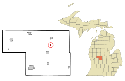
Location in Montcalm County and the state of Michigan
|
|
| Country | United States |
| State | Michigan |
| County | Montcalm |
| Township | Day |
| Area | |
| • Total | 0.39 sq mi (1.00 km2) |
| • Land | 0.39 sq mi (1.00 km2) |
| • Water | 0.00 sq mi (0.00 km2) |
| Elevation | 958 ft (292 m) |
| Population
(2020)
|
|
| • Total | 189 |
| • Density | 487.11/sq mi (188.28/km2) |
| Time zone | UTC-5 (Eastern (EST)) |
| • Summer (DST) | UTC-4 (EDT) |
| ZIP code |
48852
|
| FIPS code | 26-50000 |
| GNIS feature ID | 2399284 |
McBride is a small village located in Montcalm County, which is in the U.S. state of Michigan. In 2020, about 189 people lived here. The village is part of Day Township. It has a post office called "McBrides" with the ZIP code 48852. This post office provides P.O. box services to the village.
The Story of McBride
The village of McBride is named after Alexander B. McBride. He was a settler who came from Wayne County, New York. In 1874, he built a sawmill in this area.
A railroad station nearby was called "McBride's Mill." The post office, named "McBrides," opened on March 26, 1878. Alexander McBride himself became the first postmaster.
The village was officially mapped out, or "platted," by D. L. Jacobs in 1877. Another small settlement next to it, called "Custer," was platted by Phipps Wado in 1878. However, Custer later became part of McBride when the village officially became a town in 1883.
Where is McBride?
McBride is in the northeastern part of Montcalm County. It is about 6 miles (10 km) northeast of Stanton, which is the main town of the county. It is also about 4 miles (6 km) south of Edmore.
According to the U.S. Census Bureau, the village covers a total area of 0.39 square miles (1.00 square kilometers). All of this area is land, meaning there are no large bodies of water within the village limits.
People in McBride
| Historical population | |||
|---|---|---|---|
| Census | Pop. | %± | |
| 1890 | 333 | — | |
| 1900 | 289 | −13.2% | |
| 1910 | 236 | −18.3% | |
| 1920 | 220 | −6.8% | |
| 1930 | 204 | −7.3% | |
| 1940 | 186 | −8.8% | |
| 1950 | 223 | 19.9% | |
| 1960 | 265 | 18.8% | |
| 1970 | 272 | 2.6% | |
| 1980 | 252 | −7.4% | |
| 1990 | 236 | −6.3% | |
| 2000 | 232 | −1.7% | |
| 2010 | 205 | −11.6% | |
| 2020 | 189 | −7.8% | |
| U.S. Decennial Census | |||
A Look at 2010
In 2010, the census showed that 205 people lived in McBride. There were 83 households, which are groups of people living together. Out of these, 52 were families.
The village had about 539.5 people per square mile (208.3 people per square kilometer). There were 97 housing units, like houses or apartments. This means there were about 255.3 housing units per square mile (98.6 per square kilometer).
Most of the people in the village were White (98.0%). A small number were Asian (0.5%), and 1.5% were from two or more racial backgrounds. About 1.0% of the population was Hispanic or Latino.
- Out of the 83 households:
- 32.5% had children under 18 living with them.
- 49.4% were married couples living together.
- 9.6% had a female head of the house with no husband present.
- 3.6% had a male head of the house with no wife present.
- 37.3% were not families (meaning individuals living alone or unrelated roommates).
About 33.7% of all households were made up of people living alone. Of those, 14.4% were people aged 65 or older living by themselves. On average, each household had 2.47 people, and each family had 3.02 people.
The average age of people in the village was 39.4 years.
- 28.8% of residents were under 18 years old.
- 8.4% were between 18 and 24 years old.
- 23% were between 25 and 44 years old.
- 24.9% were between 45 and 64 years old.
- 15.1% were 65 years or older.
The village had a fairly even split between genders: 50.7% male and 49.3% female.
See also
 In Spanish: McBride para niños

