McDonald Creek (Salt Fork Brazos River tributary) facts for kids
- For the creek in Walker County, Texas, see McDonald Creek (Walker County, Texas).
Quick facts for kids McDonald Creek |
|
|---|---|

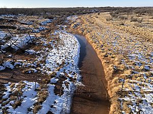
Melting snow at McDonald Creek
|
|
| Country | United States |
| Physical characteristics | |
| Main source | Crosby County, Texas 2,969 ft (905 m) |
| River mouth | Garza County, Texas 2,270 ft (690 m) |
| Length | 25 mi (40 km) |
McDonald Creek is a stream in Texas that doesn't always have water flowing in it. This type of stream is called an intermittent stream. It is about 25 mi (40 km) (40 kilometers) long.
The creek starts about 10 mi (16 km) (16 km) south-southwest of Crosbyton, Texas. It generally flows towards the southeast. McDonald Creek eventually joins a larger river called the Salt Fork Brazos River. This meeting point is near a small community in Texas called Verbena.
Contents
About McDonald Creek
McDonald Creek is special because it's an intermittent stream. This means that water only flows through it at certain times of the year. For example, it might flow after heavy rains or when snow melts. During dry periods, the creek bed can be completely dry.
The creek is located in the state of Texas, in the United States. It passes through two different counties: Crosby County, Texas and Garza County, Texas.
Where McDonald Creek Starts
McDonald Creek begins its journey along the eastern edge of a special landform called the Caprock Escarpment. This escarpment is a steep slope or cliff that marks the edge of a high, flat area known as the Llano Estacado. Think of it like the edge of a giant tableland.
The creek starts at an elevation of about 2,969 ft (905 m) (905 meters) above sea level. This is quite high up!
How McDonald Creek Flows
When McDonald Creek starts, it flows southeast. Then, it makes a turn and flows southwest. Along its path, it joins up with other smaller creeks.
- First, it merges with Turkey Creek. This happens about 5 mi (8.0 km) (8 km) west-northwest of Kalgary, Texas.
- Next, it flows south and joins Lake Creek. This meeting point is about 1 mi (1.6 km) (1.6 km) upstream from a road called Farm to Market Road 651.
Finally, the creek turns southeast again. It flows until it meets the Salt Fork Brazos River. This happens at a low-water crossing on Farm to Market Road 2008, near the small community of Verbena.
Changes in Elevation
From where it starts to where it ends, McDonald Creek drops about 700 ft (210 m) (213 meters) in elevation. This means the water flows downhill quite a bit!
The land around the creek is very interesting. It has been shaped by water over many years, making it "highly eroded." This means the water has worn away the soil and rocks, creating unique shapes and slopes. The terrain along the creek's path is also "moderately steep," meaning it has some noticeable hills and inclines.
 | Mary Eliza Mahoney |
 | Susie King Taylor |
 | Ida Gray |
 | Eliza Ann Grier |

