Menard River facts for kids
Quick facts for kids Menard |
|
|---|---|

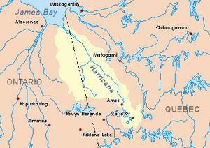
Harricana River basin in yellow
|
|
| Country | Canada |
| Province | Quebec |
| Region | Nord-du-Québec |
| Physical characteristics | |
| Main source | Lake Jos-Doire Eeyou Istchee Baie-James (municipality), Nord-du-Québec, Quebec 354 m (1,161 ft) 49°11′22″N 79°00′53″W / 49.18944°N 79.01472°W |
| River mouth | Wawagosic River Eeyou Istchee Baie-James (municipality), Nord-du-Québec, Quebec 262 m (860 ft) 49°24′28″N 79°59′18″W / 49.40778°N 79.98833°W |
| Length | 40.3 km (25.0 mi) |
The Ménard River is a river in Quebec, Canada. It flows into the Wawagosic River. A "tributary" is a smaller river or stream that flows into a larger river.
The Ménard River is located in the Nord-du-Québec region. It runs through the Lemaire and Brabazon areas.
The main activity in this area is forestry, which means cutting down trees for wood. Tourism, like visiting for fun, is also popular. There are some forest roads that help people get around.
The river usually freezes over from late November to late April. It's generally safe to walk or travel on the ice from early December to mid-April.
Contents
Where is the Ménard River?
The Ménard River is surrounded by other rivers and creeks. These include:
- The Wawagosic River to the north and south.
- The Turgeon River to the north and south.
- The Partridge River and Angle River to the east.
- The Boivin River and Patten River to the west.
The River's Beginning
The Ménard River starts at a place called Jos-Doire Lake. This lake is about 0.5 kilometers long. It is surrounded by marshy areas.
Jos-Doire Lake is located:
- About 1.0 km southwest of Mount Deloge. Mount Deloge is the highest point around, at 465 meters.
- About 14.2 km northeast of the village of Villebois, Quebec.
- About 24.3 km south of where the Ménard River joins the Wawagosic River.
- About 36.7 km east of the border between Ontario and Quebec.
The River's Journey
The Ménard River flows for about 40.3 kilometers. It flows entirely through forest areas.
Here's how it flows:
- It travels 9.6 km northwest in Lemaire township. It then meets a small creek.
- Next, it goes 6.3 km northwest to the edge of Brabazon township.
- In Brabazon Township, it flows 8.5 km north, then northeast. It forms many small streams and meets another creek.
- It then winds 2.6 km north, meeting a creek from the northwest.
- Finally, it winds 13.3 km northeast until it reaches its mouth.
Where the River Ends
The Ménard River ends when it flows into the southwest side of the Wawagosic River. This meeting point is in a forest area.
This spot is located:
- About 62.3 km southeast of where the Wawagosic River joins the Turgeon River.
- About 38.4 km east of the Ontario-Quebec border.
- About 67.1 km south of where the Turgeon River meets the Harricana River.
- About 49.8 km southwest of the village of Joutel.
What's in a Name?
The name "Ménard" is a family name that comes from France.
The name "Ménard River" was officially recognized on December 5, 1968. This happened when the Commission de toponymie du Québec was created. This commission is in charge of naming places in Quebec.
 | William Lucy |
 | Charles Hayes |
 | Cleveland Robinson |

