Mendota, California facts for kids
Quick facts for kids
Mendota, California
|
|||
|---|---|---|---|
| City of Mendota | |||

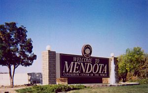
Welcome sign at south end of Mendota along Highway 180
|
|||
|
|||
| Motto(s):
The Cantaloupe Center of the World
|
|||

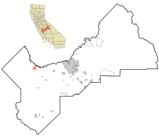
Location in Fresno County and the U.S. state of California
|
|||
| Country | United States | ||
| State | California | ||
| County | Fresno | ||
| Incorporated | June 17, 1942 | ||
| Area | |||
| • Total | 3.39 sq mi (8.78 km2) | ||
| • Land | 3.38 sq mi (8.77 km2) | ||
| • Water | 0.00 sq mi (0.01 km2) 0.10% | ||
| Elevation | 174 ft (53 m) | ||
| Population
(2020)
|
|||
| • Total | 12,595 | ||
| • Density | 3,715.34/sq mi (1,434.50/km2) | ||
| Time zone | UTC-8 (Pacific (PST)) | ||
| • Summer (DST) | UTC-7 (PDT) | ||
| ZIP code |
93640
|
||
| Area code(s) | 559 | ||
| FIPS code | 06-46828 | ||
| GNIS feature IDs | 1656159, 2411078 | ||
Mendota is a city located in Fresno County, California, United States. In 2020, about 12,595 people lived there. Major roads like State Route 180 and State Route 33 pass through this city, which is well-known for its farming. Mendota is about 8.5 miles (13.7 km) south-southeast of Firebaugh.
Contents
Exploring Mendota's Location
According to the United States Census Bureau, Mendota covers a total land area of about 3.3 square miles (8.5 square kilometers). This means almost all of the city is land. Mendota is located right next to the San Joaquin River. It's also near where the Delta-Mendota Canal meets the river. This canal helps bring extra water to the riverbed, especially when it's dry.
Mendota's Climate
Mendota has a semi-arid climate. This type of climate means it's usually dry, but not a desert. It often has hot summers and mild winters.
Mendota's Past: A Look at History
Mendota started growing in 1891. It became an important place for the Southern Pacific Railroad to store and move trains. The railroad managers chose the name "Mendota" from a city in Mendota, Illinois. The first post office opened in 1892.
The city officially became a city in 1942. Mendota is famous for growing a lot of cantaloupes. Because of this, it's known as "The Cantaloupe Center of the World." Large water projects helped bring water for farming to the area. This allowed agriculture to grow a lot.
In 2007, a new Mendota Branch Library opened. It is part of the San Joaquin Valley Library System.
Mendota has faced challenges with people finding jobs. In 2009, a drought (a long period of dry weather) and a recession (a time when the economy slows down) made it even harder for people to find work.
In 2019, a news report mentioned Mendota as a city facing challenges. However, many local people disagreed with this description. The Mayor at the time, Robert Silva, explained that job numbers can look different because farming jobs change with the seasons.
Mendota's Population Over Time
| Historical population | |||
|---|---|---|---|
| Census | Pop. | %± | |
| 1950 | 1,516 | — | |
| 1960 | 2,099 | 38.5% | |
| 1970 | 2,705 | 28.9% | |
| 1980 | 5,038 | 86.2% | |
| 1990 | 6,821 | 35.4% | |
| 2000 | 7,890 | 15.7% | |
| 2010 | 11,014 | 39.6% | |
| 2020 | 12,595 | 14.4% | |
| U.S. Decennial Census | |||
Population in 2020
In 2020, Mendota had a population of 12,595 people. Most of the people living in Mendota were of Hispanic or Latino background. About 96.6% of the population identified as Hispanic or Latino.
There were 2,424 households in the city. Many households, about 65.3%, had children under 18 living in them. The average household size was about 4.54 people.
The population was quite young. About 33.9% of the people were under 18 years old. The median age was 26.2 years. This means half the people were younger than 26.2, and half were older.
Population in 2000
In 2000, Mendota had 7,890 people living there. The average household size was 4.32 people. About 94.65% of the population was Hispanic or Latino.
The median income for a household was $23,705. This means half the households earned more than this, and half earned less. About 41.9% of the population lived below the poverty line. This includes many children and some older adults.
Learning in Mendota: Schools
The Mendota Unified School District is in charge of the schools in Mendota.
- Mendota High School
- Mendota Junior High School
- Washington Elementary School
- Mendota Elementary School
- McCabe Elementary School
- Mendota Alternative Education
Mendota's Economy: How People Work
Mendota is known for its strong farming industry. Some of the main employers in the city include Stamoules Produce, Oro Loma Ranch, Ruby Fresh, and Cardella Ranch and Winery.
The city has been called "The Cantaloupe Center of the World" because of how much cantaloupe it produces. However, recent climate changes, like droughts and high temperatures, have affected cantaloupe farming. This has also impacted how much the local population grows.
Federal Correctional Institution, Mendota
The Federal Correctional Institution, Mendota is a federal prison located about 1 mile (1.6 km) south of downtown Mendota. You can spot it by its tall water tower. This facility was built on 960 acres (388 hectares) of land. It cost over $110 million to build.
The prison opened in 2012. It includes a medium-security section for up to 1,152 adults. There is also a smaller, minimum-security camp for 128 people. About 300 to 350 staff members work there full-time.
Mendota Wildlife Area: Nature's Home
In 1956, the State of California bought 6,100 acres (2,469 hectares) of land near the San Joaquin River. This land is a winter home for waterfowl (birds like ducks and geese). This area was then named the Mendota Wildlife Area.
This special wildlife preserve is about 1 mile (1.6 km) southeast of downtown Mendota. You can find the entrance on the south side of CA Route 180.
See also
In Spanish: Mendota (California) para niños
 | Kyle Baker |
 | Joseph Yoakum |
 | Laura Wheeler Waring |
 | Henry Ossawa Tanner |


