Meringandan West, Queensland facts for kids
Quick facts for kids Meringandan WestQueensland |
|||||||||||||||
|---|---|---|---|---|---|---|---|---|---|---|---|---|---|---|---|

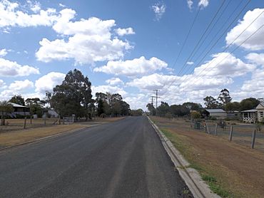
Clifford Street, 2014
|
|||||||||||||||
| Population | 2,488 (2021 census) | ||||||||||||||
| • Density | 149.9/km2 (388/sq mi) | ||||||||||||||
| Postcode(s) | 4352 | ||||||||||||||
| Area | 16.6 km2 (6.4 sq mi) | ||||||||||||||
| Time zone | AEST (UTC+10:00) | ||||||||||||||
| Location |
|
||||||||||||||
| LGA(s) | Toowoomba Region | ||||||||||||||
| State electorate(s) | Condamine | ||||||||||||||
| Federal Division(s) | Groom | ||||||||||||||
|
|||||||||||||||
Meringandan West is a country area, also called a locality, in the Toowoomba Region of Queensland, Australia. In 2021, about 2,488 people lived there.
Contents
Exploring Meringandan West's Location
Meringandan West is located in a part of southern Queensland known as the Darling Downs. A creek called Meringandan Creek forms most of its eastern border, separating it from the nearby area of Meringandan.
Mountains and Development
In the north-west of Meringandan West, you'll find Mount Muniganeen. This mountain stands about 613 meters (2,011 feet) above sea level.
Some central parts of Meringandan West have been developed into homes and neighborhoods. The local council, Toowoomba Region Council, made a plan in 2013 to guide how the area would grow.
A Look Back at Meringandan West's History
The name Meringandan comes from an old railway station. It's a Gooneburra word that means red soil or broken clay.
Early School Days
Meringandan State School first opened its doors on January 24, 1876. It was built in 1875 by a person named Jack Maag. The very first head teacher was Isaac John Thomas. When the school opened, 80 students were enrolled. Today, this school is located within the boundaries of Meringandan West.
The Meringandan Cemetery
The Meringandan Cemetery was first mapped out on October 13, 1876. Local people managed it until 2004. After that, it was looked after by the Rosalie Shire Council and then by the Toowoomba Regional Council from 2008. This change happened when local government areas joined together.
Who Lives in Meringandan West?
In 2016, the population of Meringandan West was 2,211 people. By 2021, the number of people living there grew to 2,488.
Learning and Education
Meringandan State School is a government primary school for students from Prep (the first year of school) to Year 6. It teaches both boys and girls and is located at 10 School Road. In 2017, the school had 240 students and 20 teachers.
There are no high schools directly in Meringandan West. The closest government high school is Highfields State Secondary College, which is located in Highfields to the south-east.
Community Facilities and Parks
Lilyvale Oval is a local park that was once used for an annual rodeo. This event was put on by the Parents and Citizens (P&C) group of Meringandan State School. The P&C also used to organize Christmas Carols at the park, but these events stopped due to a lack of money. However, small church groups still use the park for their annual carol nights.
Meringandan Cemetery and Other Parks
The Meringandan Cemetery is a 10-acre site on the eastern side of Peters Road. The Toowoomba Regional Council manages it.
Meringandan West has several parks scattered around. Lilyvale Oval is one of the most important parks. It has a sports field (with a cricket pitch) that isn't lit up at night. Sometimes, local people and visitors use it for flying radio-controlled model airplanes. It also helps manage floodwaters. The park includes a playground, picnic tables, a community shed, a barbecue area, and public toilets.
Next to Lilyvale Oval, there is a shed that serves as the base for the local rural fire brigade.
 | Isaac Myers |
 | D. Hamilton Jackson |
 | A. Philip Randolph |


