Mescal Range facts for kids
Quick facts for kids Mescal Range |
|
|---|---|

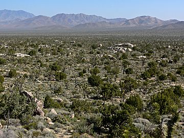
Viewed from Cima Dome, the Mescal Range is the ridge on the horizon slightly left of center
|
|
| Highest point | |
| Elevation | 1,981 m (6,499 ft) |
| Geography | |
| Country | United States |
| State | California |
| District | San Bernardino County |
| Range coordinates | 35°26′27.938″N 115°33′7.991″W / 35.44109389°N 115.55221972°W |
| Topo map | USGS Mescal Range |
The Mescal Range is a small group of mountains located in the eastern part of the Mojave Desert in California. These mountains are about 12 miles (19 kilometers) away from the Nevada state line. It's a neat place to explore if you're interested in desert landscapes and geology!
Where is the Mescal Range?
The Mescal Range is easy to spot if you're traveling on Interstate 15. It sits just south of this major highway, close to a spot called Mountain Pass.
- To the north of the Mescal Range, you'll find the Clark Mountain Range.
- If you look southeast, you'll see the Ivanpah Mountains, with Paiute Valley in between.
- To the west, there's a wide, flat area known as Shadow Valley.
These mountains are not super long, stretching for about six miles (9.7 kilometers).
Exploring the Mescal Range
Even though the Mescal Range is small, it has some interesting history, especially with mining. People have explored these mountains for valuable minerals.
Mines in the Mountains
Along the eastern side of the Mescal Range, you can find old mining sites. Some of these include:
- The Mollusk Mine
- The Blue Buzzard Mine
- The Iron Horse Mine
These mines show that people were once very active here, looking for different kinds of rocks and metals hidden within the mountains.
 | Misty Copeland |
 | Raven Wilkinson |
 | Debra Austin |
 | Aesha Ash |


