Clark Mountain Range facts for kids
Quick facts for kids Clark Mountain Range |
|
|---|---|

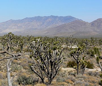
The entire range is visible on the skyline seen from Cima Dome to the southwest.
|
|
| Highest point | |
| Elevation | 2,418 m (7,933 ft) |
| Geography | |
| Country | United States |
| State | California |
| District | San Bernardino County |
| Range coordinates | 35°34′54.929″N 115°33′24.998″W / 35.58192472°N 115.55694389°W |
| Topo map | USGS Clark Mountain |
The Clark Mountain Range is a mountain range found in southeastern California. It's located in the Mojave Desert, just north of the I-15 highway and the small community of Mountain Pass. This mountain range stretches for about 15 miles (24 km). It starts in the Mojave National Preserve and ends close to the Nevada border. The highest point in the range is Clark Mountain, which stands tall at 7,929 feet (2,417 m) above sea level.
Exploring the Clark Mountain Range
The Clark Mountain Range is a special place in the desert. It's known for its unique plants and its interesting location.
What Plants Grow Here?
The lower parts of the mountains, called the foothills, are covered in creosote bushes and forests of Joshua trees. These Joshua tree forests connect to the very thick woodlands on top of Cima Dome.
As you go higher up the mountains, above 6,000 feet (1,800 m), you'll find a special area called a "sky island." This is where occasional rains allow different kinds of trees to grow, like pinyon pine and juniper. These trees usually need more water than the desert provides, so it's like a small island of green in the dry landscape.
On the north side of the highest peaks, there's even a small forest of white fir trees. These trees are very rare in California's deserts. It's quite hard to reach this forest! The Clark Mountain Range is one of only three places in California where you can find these special Rocky Mountain white fir – Abies concolor trees. The other two places are the Kingston and New York Mountains.
Nearby Features and Mining
The I-15 highway goes through a mountain pass between the Clark Mountain Range and the Mescal Range to the south. The small town of Mountain Pass is located just south of the range, right next to the I-15 highway.
An important place near the mountains is the Mountain Pass rare earth mine. This mine is owned by Molycorp Minerals. It's a place where special materials called rare earth elements are dug out of the ground. These elements are used in many modern technologies, like smartphones and computers. The mine started working again in recent years, and a big project to expand it began in 2011.
The Clark Mountain Range also contains other interesting spots like Keany Pass and the Umberei Mine.
 | DeHart Hubbard |
 | Wilma Rudolph |
 | Jesse Owens |
 | Jackie Joyner-Kersee |
 | Major Taylor |


