Milecastle 34 facts for kids
Quick facts for kids Milecastle 34 |
|
|---|---|
| Northumberland, England, UK | |

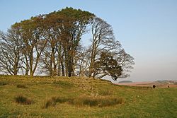
The walled plantation marking the site of Milecastle 34
|
|
|
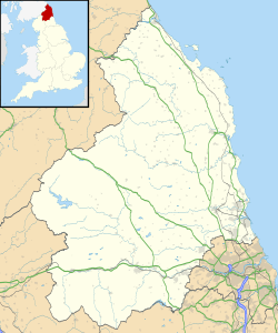
Location in Northumberland
|
|
| Coordinates | 55°01′43″N 2°17′16″W / 55.028706°N 2.287715°W |
Milecastle 34 (Grindon) was a small fort or guard post built by the Romans. It was an important part of Hadrian's Wall, a huge stone wall that stretched across northern England. Today, you can't see any remains of Milecastle 34. Its location is marked by a small, tree-filled area surrounded by a wall. This spot is about 0.5 kilometers east of Sewingshields farm.
Contents
Building Milecastle 34
Milecastle 34 was designed with a "long-axis," meaning it was longer than it was wide. It also had special "Type II gateways." Experts believe that the legio XX Valeria Victrix, a Roman army group, built this milecastle. This army group was based in a city called Deva Victrix, which is now known as Chester.
Exploring the Past: Investigations
Historians and archaeologists have studied the site of Milecastle 34 over the years. They wanted to learn more about its history.
- 1947 - Researchers figured out the milecastle's shape and the type of gateways it had.
- 1965 - English Heritage, a group that looks after historical sites, checked the area. They confirmed that there were no visible remains. But they knew the milecastle was inside the walled area.
- 1988 - English Heritage did another study as part of a big project on Hadrian's Wall. Their findings matched what was discovered before.
What are Turrets?
Every milecastle along Hadrian's Wall had two smaller guard posts called turrets. These turrets were placed about one-third and two-thirds of a Roman mile to the west of the milecastle. Soldiers from the milecastle would have guarded these turrets. The turrets connected to Milecastle 34 are known as Turret 34A and Turret 34B.
Turret 34A: A Closer Look
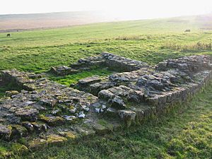
Turret 34A (Grindon West) is still partly standing today. It's found exactly where it should be, just east of Sewingshields farm. This turret was built with narrow walls, about 0.95 meters thick. The walls had a strong mortar core.
Like some milecastles, Turret 34A has unusually short "wing walls." These are small walls that stick out from the main structure. This design suggests it was built later than other parts of the wall. The main wall and the turret's wing walls were made from large whinstone blocks.
Inside the turret, there might have been a raised platform in the southwest corner. The entrance door was on the east side of the south wall. It was about 1.15 meters wide. A threshold stone (the stone at the bottom of the doorway) is still there, though it's worn. You can see where stone door frames and a pivot for the door would have been. The inside of the turret measured about 3.9 meters from east to west and 2.3 meters wide. Outside the door, archaeologists found a path made of small stones and pieces of amphora (Roman storage jars).
Workers helped preserve the structure of Turret 34A. This was done first in 1912 and again in 1971. They built the walls up to a height of 0.6 meters.
Archaeologists dug at this site in 1913, 1947, 1958, and 1971. They found many interesting things. These included a javelin-head, a brooch, and a coin from the Roman emperor Vespasian. They also found pieces of fine Roman pottery called Samian ware.
Inside, they found three scattered fireplaces, which were later replaced by one. There were also many animal bones and broken pottery pieces, mostly from cooking pots. The discovery of green-glazed pottery showed that people also lived here during the medieval period, long after the Romans left.
You can find Turret 34A on an Ordnance Survey map at these coordinates: 54°59′37″N 1°44′12″W / 54.993672°N 1.736733°W (Ordnance Survey National Grid Coordinates: NY 8127 7043).
Turret 34B: Hidden History
The exact spot where Turret 34B was located is now covered by a farmhouse called Sewingshields Farm. This farmhouse was actually built using stones from the old Roman structures! Because of this, you can't see any remains of Turret 34B today.
Its predicted location is: 55°01′36″N 2°18′01″W / 55.026726°N 2.300230°W (Ordnance Survey National Grid Coordinates: NY 8090 7028).
Official Records
Historical sites like these are given special numbers for record-keeping.
| Monument | Record Number | English Heritage Archive Number |
| Milecastle 34 | 16820 | NY 87 SW 7 |
| Turret 34A | 16821 | NY 87 SW 8 |
| Turret 34B | 16826 | NY 87 SW 9 |
Visiting the Sites
Both Milecastle 34 and Turret 34A are easy to reach. They are located right along the Hadrian's Wall Path, a popular walking trail. However, since Turret 34B is under a farmhouse, you cannot visit its exact location.
 | Shirley Ann Jackson |
 | Garett Morgan |
 | J. Ernest Wilkins Jr. |
 | Elijah McCoy |


