Milton Mills, New Hampshire facts for kids
Quick facts for kids
Milton Mills, New Hampshire
|
|
|---|---|

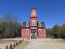
Milton Free Public Library, listed on the New Hampshire State Register of Historic Places
|
|
| Country | United States |
| State | New Hampshire |
| County | Strafford |
| Town | Milton |
| Area | |
| • Total | 0.87 sq mi (2.25 km2) |
| • Land | 0.86 sq mi (2.23 km2) |
| • Water | 0.01 sq mi (0.02 km2) |
| Elevation | 462 ft (141 m) |
| Population
(2020)
|
|
| • Total | 313 |
| • Density | 363.11/sq mi (140.25/km2) |
| Time zone | UTC-5 (Eastern (EST)) |
| • Summer (DST) | UTC-4 (EDT) |
| ZIP code |
03852
|
| Area code(s) | 603 |
| FIPS code | 33-48740 |
| GNIS feature ID | 0868472 |
Milton Mills is a small village in New Hampshire, United States. It is part of the town of Milton. In 2020, about 313 people lived there. Milton Mills has its own special ZIP code, which is 03852. This is different from the rest of Milton. It is also known as a census-designated place, or CDP. This means it is an area that the government counts for population, but it's not an officially separate town.
Contents
Exploring Milton Mills' Location
This village is located in the northern part of Milton. It sits right next to the Salmon Falls River. This river actually forms the border between New Hampshire and Maine.
Roads Connecting Milton Mills
Several roads help people get around Milton Mills and to nearby places:
- Applebee Road goes southwest to New Hampshire Route 125. This road leads to the center of Milton.
- Willey Road heads northwest towards Wakefield.
- Milton Mills Road goes east into Maine. It connects to Maine State Route 109 in Acton, Maine.
- Foxes Ridge Road leads southeast to Lebanon, Maine. It also connects to U.S. Route 202.
Milton Mills' Size and Water Areas
The total area of Milton Mills is about 2.2 square kilometers (0.87 square miles). Most of this area is land. Only a tiny part, about 0.02 square kilometers (0.01 square miles), is water. The Salmon Falls River is part of a larger water system called the Piscataqua River watershed.
Milton Mills' Population Facts
| Historical population | |||
|---|---|---|---|
| Census | Pop. | %± | |
| 2010 | 299 | — | |
| 2020 | 313 | 4.7% | |
| U.S. Decennial Census | |||
In 2010, there were 299 people living in Milton Mills. By 2020, the population grew slightly to 313 people.
Households and Families in Milton Mills
In 2010, there were 111 households in the village. A household is a group of people living together. Out of these, 85 were families. Most people living in Milton Mills were white. A very small number were from two or more races.
Age Groups in the Village
The people living in Milton Mills come from different age groups:
- About 26% of residents were under 18 years old.
- Around 8% were young adults aged 18 to 24.
- About 22% were adults aged 25 to 44.
- The largest group, about 31%, were aged 45 to 64.
- About 12% were 65 years old or older.
The average age in Milton Mills was about 40.4 years.
See also
In Spanish: Milton Mills para niños
 | Victor J. Glover |
 | Yvonne Cagle |
 | Jeanette Epps |
 | Bernard A. Harris Jr. |


