Minho (river) facts for kids
Quick facts for kids MinhoMiño |
|
|---|---|

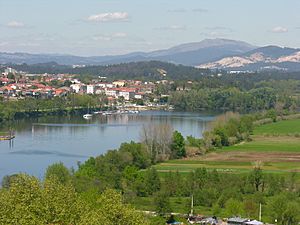
The river Minho, and the town of Tui, as seen from Valença
|
|

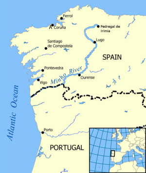
Map showing the location of the Minho
|
|
| Country | Spain, Portugal |
| City | Lugo, Ourense |
| Physical characteristics | |
| Main source | Pedregal de Irimia Serra de Meira, Lugo, Galicia, Spain 695 m (2,280 ft) 43°12′41″N 7°16′52″W / 43.21139°N 7.28111°W |
| River mouth | Miño Estuary. Near Caminha, Portugal. Atlantic Ocean, Spain 0 m (0 ft) 41°52′0″N 8°52′12″W / 41.86667°N 8.87000°W |
| Length | 350 km (220 mi) |
| Basin features | |
| Reservoirs | Belesar, Peares, Velle, Castrelo and Frieira |
The Minho River (also called Miño) is a very important river in Spain and Portugal. It is the longest river in Galicia, a region in Spain. The river is about 340 kilometres (210 mi) long. It also forms part of the border between Spain and Portugal.
The Minho River helps grow many vineyards and farms. It is also used to create hydroelectric power, which is electricity made from water. In old maps from England, the river was sometimes called "Minno."
The Minho River starts in a place called Pedregal de Irimia, north of Lugo in Galicia. After flowing for about 73 kilometres (45 mi), it passes near the old Roman city of Lugo. The river then flows south through deep valleys.
The river has several large reservoirs along its path. These are like big lakes created by dams. They help control the water and produce electricity. Some of these reservoirs include Belesar, Peares, Velle, Castrelo, and Frieira.
About 20 kilometres (12 mi) north of Ourense, another important river called the Sil joins the Minho. The Sil River adds a lot of water to the Minho. After Ourense, there is a big dam at Frieira. This area is famous for its special "Ribeiro DOP" wine.
The Minho River then flows southwest. It reaches the border with Portugal near Melgaço.
For about 80 kilometres (50 mi), the Minho River acts as the border between Spain and Portugal. This valley is very green and good for farming. Farmers grow things like corn, potatoes, cabbage, and even kiwi fruit here. The area is also famous for its unique "Vinho Verde" and "Ribeiro" wines. The best of these wines, called Alvarinho or Albariño, comes from around Monção, Arbo, and Melgaço.
The river passes by old towns like Melgaço and Monção. It also separates the Spanish town of Tui from the Portuguese town of Valença do Minho. These towns have old forts and are important historical sites. Finally, the Minho River flows into the Atlantic Ocean between A Guarda in Spain and Caminha in Portugal.
Where the River Begins
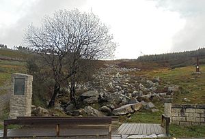
The Minho River starts high up in the mountains, about 695 metres (2,280 ft) above sea level. This spot is called the Pedregal de Irimia, in the Sierra de Meira. It is located in the northeast part of the province of Lugo. The river flows through the town of Meira.
The Minho River flows through very rainy areas of Spain. This makes it one of the main rivers that flows into the Atlantic Ocean. The upper part of the river has been named a Biosphere Reserve. This means it is a special area protected for its nature and wildlife.
The river flows for its first 64 kilometres (40 mi) across a flat area called the plateau of Lugo. This area is between 450 to 650 metres (1,480 to 2,130 ft) above sea level.
River Name History
The name "Minho" comes from a very old European river name, Minius or Mineus. Experts believe it comes from an ancient word that means "walk" or "go."
Legends and Stories
The Minho River has many old stories and legends from Galicia. People used to tell tales about magical creatures living in or near the river.
Some stories talk about feiticeiras, which are like witches, who lived in the river itself. There were also stories of Xarcos, who lived in wells along the river. Another legend tells of "fish-men," who were special beings that could live both on land and in the water. These stories show how important the river was to the people who lived there long ago.
Tributaries
The Minho River has many smaller rivers that flow into it. These smaller rivers are called tributaries. Some of its main tributaries include the Sil, Neira, Avia, Barbantiño, Búbal, and Arnoya rivers. These rivers help to fill the Minho with water as it flows towards the ocean.
See also
 In Spanish: Río Miño para niños
- List of rivers of Portugal
- List of rivers of Spain
- Rivers of Galicia
 | Mary Eliza Mahoney |
 | Susie King Taylor |
 | Ida Gray |
 | Eliza Ann Grier |


