Mitchellville, Tennessee facts for kids
Quick facts for kids
Mitchellville, Tennessee
|
|
|---|---|

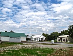
Buildings along Church Street
|
|

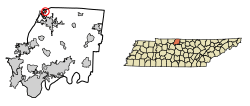
Location of Mitchellville in Sumner County, Tennessee.
|
|
| Country | United States |
| State | Tennessee |
| County | Sumner |
| Area | |
| • Total | 0.54 sq mi (1.39 km2) |
| • Land | 0.54 sq mi (1.39 km2) |
| • Water | 0.00 sq mi (0.00 km2) |
| Elevation | 778 ft (237 m) |
| Population
(2020)
|
|
| • Total | 163 |
| • Density | 303.54/sq mi (117.22/km2) |
| Time zone | UTC-6 (Central (CST)) |
| • Summer (DST) | UTC-5 (CDT) |
| ZIP code |
37119
|
| Area code(s) | 615 |
| FIPS code | 47-49460 |
| GNIS feature ID | 1306760 |
Mitchellville is a small city located in Sumner County, Tennessee, in the United States. In 2020, about 163 people lived there. It's a quiet place with a rich history tied to early settlements and railroads.
Contents
History of Mitchellville
Mitchellville started as a farm in 1814. A man named Ezekiel Marshall set up this farm, which was about 200 acres big. The small community that grew around his farm was first called Mitchell's Cross Roads. This name came from Hiram Mitchell, who owned land where two old roads met.
When the railroad arrived in 1859, the community's name changed to Mitchellville Station. The city officially became a city in 1909. For the first half of the 1900s, Mitchellville was a busy and successful railroad stop. However, in the 1950s, fewer trains used the railway, and the city started to decline. A powerful tornado hit Mitchellville in 1955, and the city never fully recovered from the damage.
Geography of Mitchellville
Mitchellville is located in the northern part of central Tennessee. It's very close to where three different areas meet: Sumner County (where Mitchellville is), Robertson County in Tennessee, and Simpson County in Kentucky.
State Route 259 is a main road that goes right through Mitchellville, running from east to west. If you travel west on this highway from Mitchellville, you'll reach State Route 109. This road can take you south to Portland. State Route 259 also connects to U.S. Route 31W, which goes north to Franklin, Kentucky.
The United States Census Bureau says that Mitchellville covers a total area of about 0.5 square miles (1.3 square kilometers). All of this area is land, meaning there are no large bodies of water like lakes or rivers within the city limits.
Population and People
Mitchellville has always been a small community. Here's how its population has changed over the years:
| Historical population | |||
|---|---|---|---|
| Census | Pop. | %± | |
| 1920 | 161 | — | |
| 1930 | 203 | 26.1% | |
| 1940 | 216 | 6.4% | |
| 1950 | 202 | −6.5% | |
| 1960 | 184 | −8.9% | |
| 1970 | 177 | −3.8% | |
| 1980 | 209 | 18.1% | |
| 1990 | 193 | −7.7% | |
| 2000 | 207 | 7.3% | |
| 2010 | 189 | −8.7% | |
| 2020 | 163 | −13.8% | |
| Sources: | |||
2020 Census Information
The 2020 United States census counted 163 people living in Mitchellville. There were 55 households, which means 55 different homes where people lived. Out of these, 45 were families.
Most of the people in Mitchellville are White (non-Hispanic), making up about 89.57% of the population. A smaller number of residents are Black or African American (non-Hispanic), about 1.84%. Some people identify as "Other/Mixed" race, making up about 4.91%. Lastly, about 3.68% of the population identified as Hispanic or Latino.
See also
 In Spanish: Mitchellville (Tennessee) para niños
 | Aaron Henry |
 | T. R. M. Howard |
 | Jesse Jackson |


