Moe River (rivière aux Saumons tributary) facts for kids
Quick facts for kids Moe River |
|
|---|---|

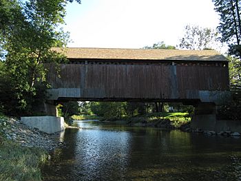
Milby Bridge on the Moe River near Waterville
|
|
| Native name | Rivière Moe |
| Country | Canada |
| Province | Quebec |
| Region | Estrie |
| Ville | Sherbrooke |
| Physical characteristics | |
| Main source | Unidentified lake East Hereford 462 m (1,516 ft) 45°05′08″N 71°29′55″W / 45.085675°N 71.498688°W |
| River mouth | Rivière aux Saumons Sherbrooke 150 m (490 ft) 45°19′07″N 71°49′27″W / 45.31861°N 71.82417°W |
| Length | 36.7 km (22.8 mi) |
| Basin features | |
| Progression | Rivière aux Saumons, Massawippi River, Saint-François River, Saint Lawrence River |
| Tributaries |
|
The Moe River is a beautiful watercourse in the Estrie region of Quebec, Canada. It's like a smaller stream that flows into the Rivière aux Saumons. From there, its water joins the Massawippi River, then the Saint-François River, and finally the mighty Saint Lawrence River. So, the Moe River is a small but important part of a much bigger river system!
Contents
River's Journey
The Moe River starts its journey from a lake near East Hereford. It flows for about 36.7 km (22.8 mi), which is roughly 22.8 miles. During its trip, the river drops about 302 m (991 ft) (991 feet) in elevation. This drop creates a winding path, sometimes with rapids!
Upper Part of the River
In its upper section, the Moe River flows mostly west and northwest. It passes through forest areas and crosses a few roads, like Chemin Saint-Jacques and Route 251. It also goes near the Saint-Herménégilde airport. Along this part, the river gets water from small streams and lakes, including Lac Lippé and Lac Duquette. It winds through both forests and farmlands.
Lower Part of the River
As the river continues, it flows more to the north. It crosses several roads, including Cookshire Road and Ives Hill Road. You can find some rapids in this section, which are exciting parts where the water flows quickly over rocks. The river eventually reaches the Milby Bridge, which is a well-known spot.
Where the River Ends
The Moe River is fed by many small streams, especially from the area around Mount Hereford. It has a very narrow and winding path. The river flows through the village of Compton. It finally joins the Rivière aux Saumons near Lennoxville. This area is now part of Sherbrooke, in the Estrie region.
River's Name and History
The name "Moe River" helps us remember a man named Austin Moe. He came from Vermont and settled in Ascot Township way back in 1795. Austin Moe was a business partner of Gilbert Hyatt, who founded a place called Hyatt's Mills. This place later grew into the city of Sherbrooke.
Around the mid-1800s, a small farming community called Moe's River grew up on the west side of the river. Even though the area mostly speaks French now, the English spelling of the river's name, "Moe," stayed the same for a long time. Sometimes, people even spelled it "Moes" without the apostrophe.
The official name "rivière Moe" was made official on December 13, 1996, by the Commission de toponymie du Québec. This group is in charge of naming places in Quebec.
 | William L. Dawson |
 | W. E. B. Du Bois |
 | Harry Belafonte |


