Moore, Utah facts for kids
Quick facts for kids
Moore, Utah
|
|
|---|---|

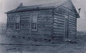
Moore (Rochester) School House 1912
|
|
| Country | United States |
| State | Utah |
| County | Emery |
| Settled | c. 1895 |
| Named for | L. C. Moore |
| Area | |
| • Total | 1.3 sq mi (3.4 km2) |
| • Land | 1.3 sq mi (3.4 km2) |
| • Water | 0.0 sq mi (0.0 km2) |
| Elevation | 6,247 ft (1,904 m) |
| Population
(2000)
|
|
| • Total | 5 |
| • Density | 5/sq mi (5/km2) |
| Time zone | UTC-7 (Mountain (MST)) |
| • Summer (DST) | UTC-6 (MDT) |
| ZIP code |
84522
|
| Area code(s) | 435 |
| FIPS code | 49-56860 |
| GNIS feature ID | 1442870 |
Moore is a small, quiet community in Emery County, Utah. It's not a big city with its own government, but rather an "unincorporated community." This means it's a group of homes and farms without a city hall or mayor. Moore is located right next to the amazing San Rafael Swell, a huge area of cool rock formations and canyons.
What is Moore, Utah?
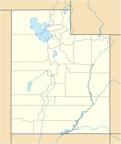
Moore is a small, populated place in Emery County, Utah. It sits at an elevation of 6,247 feet (about 1,904 meters) above sea level. You can find it on maps using its coordinates: 38.967 degrees North and -111.154 degrees West.
This community is located where two county roads, County Road 801 and County Road 803 (also called the Moore Cut-off), meet. In the year 2000, only 5 people lived in Moore.
Moore's History: From Rochester to Today
| Historical population | |||
|---|---|---|---|
| Census | Pop. | %± | |
| 1930 | 114 | — | |
| 1940 | 47 | −58.8% | |
| 1950 | 41 | −12.8% | |
| 2000 | 5 | — | |
| Source: U.S. Census Bureau | |||
Moore was first called Rochester. It got this name from M. B. Whitney's hometown in New York. He helped develop the area. Around the same time, people in a nearby town called Emery were building a canal.
Investors from the Eastern United States saw how fertile the land was near the Muddy River. They thought this dry land could grow lots of grain, just like in the Midwest. So, they created The Independent Canal Company. Their goal was to bring water from Muddy Creek to make the land productive.
Local people in Emery County also believed in this idea. They bought shares in the company and started digging and blasting to build a new canal. This canal would bring water for farming and for the town itself. The early town had a store, a brick school, and a post office.
In 1907, the Eastern investors left the company. L. C. Moore became the new leader for the land development project. He was also the postmaster. Because of his work, the community was renamed Moore in 1940.
Today, only a few people still live in Moore. Most residents have moved to nearby towns. However, many still own their farmland in Moore. This land continues to produce great crops.
Ancient History in Moore
The area around Moore was also important to older civilizations. One of these was the Fremont culture. This culture lived in Emery County from about 700 to 1000 AD.
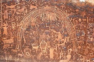
Later, during the Bull Creek phase (1000–1200 AD), the weather became wetter. This allowed for more farming and larger groups of people living together. You can still see amazing rock art panels around Moore, like the Rochester Rock Art Panel, left by these ancient people.
 | Aurelia Browder |
 | Nannie Helen Burroughs |
 | Michelle Alexander |


