
Morovis Norte facts for kids
Quick facts for kids
Morovis Norte
|
|
|---|---|
|
Barrio
|
|

Maga Street in Morovis Norte
|
|

Location of Morovis Norte within the municipality of Morovis shown in red
|
|

Morovis Norte
Location in Caribbean
|
|
| Commonwealth | |
| Municipality | |
| Area | |
| • Total | 3.31 sq mi (8.6 km2) |
| • Land | 3.31 sq mi (8.6 km2) |
| • Water | 0 sq mi (0 km2) |
| Elevation | 518 ft (158 m) |
| Population
(2010)
|
|
| • Total | 3,546 |
| • Density | 1,071.3/sq mi (413.6/km2) |
| Source: 2010 Census | |
| Time zone | UTC−4 (AST) |
| Zip code |
00687
|
Morovis Norte is a special area called a barrio in the town of Morovis, Puerto Rico. Think of a barrio like a neighborhood or a part of a larger town. Morovis Norte has about 15 smaller areas called sectors. In 2010, about 3,546 people lived here.
Contents
History of Morovis Norte
How Morovis Norte Became Part of the U.S.
Long ago, after the Spanish–American War, Spain gave Puerto Rico to the United States. This happened in 1898 as part of the Treaty of Paris of 1898. Puerto Rico then became an unincorporated territory of the United States. This means it's a part of the U.S. but doesn't have all the same rights as a state.
In 1899, the U.S. government counted everyone living in Puerto Rico. They found that 821 people lived in Morovis Norte barrio at that time.
The Famous Red Bridge
One important landmark in Morovis Norte is the Puente Colorao, which means "Red Bridge." This bridge is located on Road PR-155 and crosses over the Indio River. It helps connect Morovis Norte to the main downtown area of Morovis, where you can find town buildings and stores.
The United States Army Corps of Engineers built this strong bridge in 1913. It has been an important part of the community for over 100 years! In June 2020, the bridge was closed for some repairs to keep it safe for everyone.
Population Growth Over Time
The number of people living in Morovis Norte has changed a lot over the years. Here's a quick look at how the population has grown:
| Historical population | |||
|---|---|---|---|
| Census | Pop. | %± | |
| 1900 | 821 | — | |
| 1980 | 1,393 | — | |
| 1990 | 2,556 | 83.5% | |
| 2000 | 3,257 | 27.4% | |
| 2010 | 3,546 | 8.9% | |
| U.S. Decennial Census 1899 (shown as 1900) 1910-1930 1930-1950 1980-2000 2010 |
|||
Sectors of Morovis Norte
What are Sectors?
Barrios like Morovis Norte are divided into even smaller areas. These smaller parts are called sectores (pronounced sek-TOH-res). Think of sectors as mini-neighborhoods within the barrio.
There are different types of sectors. Some are just called "sector," while others might be named "urbanización" (a planned housing area), "reparto" (a land division), "barriada" (a neighborhood), or "residencial" (a residential area).
Main Sectors in Morovis Norte
Morovis Norte is home to several different sectors. Each one has its own unique feel. Here are some of the sectors you can find in Morovis Norte:
- Apartamentos Santiago
- Sector Buena Vista
- Sector El Cerro
- Sector El Tendal
- Sector Hoyo Frío
- Sector La Línea
- Sector Los Russe
- Sector Puente Colorao
- Urbanización Brisas del Norte
- Urbanización Cruz Rosario
- Urbanización Jardines de Romaní
- Urbanización Las Cumbres
- Urbanización Quintas de Morovis
- Urbanización Tajaomar
- Urbanización Villas Del Norte
Images for kids
-
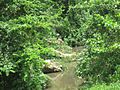
The Indio River as seen from the Red Bridge (Puente Colorao) in Morovis Norte.
-
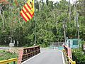
A closer look at the Red Bridge in the Sector Puente Colorao.


See also
- List of communities in Puerto Rico
 In Spanish: Morovis Norte (Morovis) para niños
