Morven, Georgia facts for kids
Quick facts for kids
Morven, Georgia
|
||
|---|---|---|

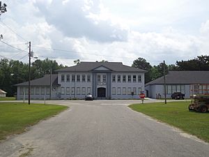
Morven City Hall
|
||
|
||

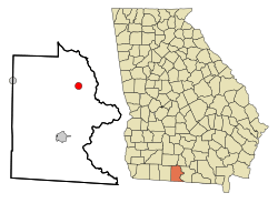
Location in Brooks County and the state of Georgia
|
||
| Country | United States | |
| State | Georgia | |
| County | Brooks | |
| Area | ||
| • Total | 1.74 sq mi (4.51 km2) | |
| • Land | 1.73 sq mi (4.47 km2) | |
| • Water | 0.02 sq mi (0.04 km2) | |
| Elevation | 217 ft (66 m) | |
| Population
(2020)
|
||
| • Total | 506 | |
| • Density | 293.33/sq mi (113.27/km2) | |
| Time zone | UTC-5 (Eastern (EST)) | |
| • Summer (DST) | UTC-4 (EDT) | |
| ZIP code |
31638
|
|
| Area code(s) | 229 | |
| FIPS code | 13-53032 | |
| GNIS feature ID | 0318505 | |
Morven is a small city located in Brooks County, Georgia, United States. It is part of the larger Valdosta area. The city got its name from a mountain in Scotland. In 2010, about 565 people lived there, and by 2020, the population was 506. Before it was called Morven, it was known as Sharpe's Store.
Contents
History
Morven is the oldest community in Brooks County that was settled by Europeans. Around 1750, Spanish missionaries came to this area.
Early Settlement and Growth
The Coffee Road was built through Morven around 1823. Sion Hall, one of the first people to settle here, saw a chance to use his sawmill and start farming. The area became known for large cotton farms, which relied on the labor of enslaved African Americans.
Around 1826, Hamilton Sharpe built a store out of logs. He opened a post office there in 1828. In the same year, a church camp was set up and called Mount Zion. The post office moved in 1853 and was renamed Morven. Later, in 1897, the South Georgia Railroad was built through the city. Morven officially became a city in 1900.
Cotton farming remained very important in the early 1900s.
Modern Developments
Another railroad, the Valdosta/Morven & Western RR, was built through Morven in the 1920s. In 1923, the town raised $8,000 to build a water system. A group of local women worked together to get electric lights installed in August 1924. After World War II, the first paved road in Morven was built between 1948 and 1949. This road connected Morven to Quitman, which is the main town of Brooks County.
Geography
Morven is located at 30°56′39″N 83°30′03″W / 30.94417°N 83.50083°W.
The city covers a total area of about 4.5 square kilometers (1.74 square miles). Most of this area is land, with only a small part (about 0.04 square kilometers or 0.02 square miles) being water.
Morven is found where State Highways 76 and 94 meet. It is also about 8 miles (13 km) west of Interstate 75, a major highway.
Historical Sites
Coffee Road
The Coffee Road was created by a state law passed on December 23, 1822. $1500 was set aside to build this road. It started near Cunningham Ford on the Alapaha River and went southwest through different parts of Irwin County and Early County. It ended near the Florida state line, close to the Ocklocknee River.
Old Morven School
Population
Morven's population has changed over the years. Here's how it has grown and shrunk:
| Historical population | |||
|---|---|---|---|
| Census | Pop. | %± | |
| 1910 | 383 | — | |
| 1920 | 530 | 38.4% | |
| 1930 | 491 | −7.4% | |
| 1940 | 512 | 4.3% | |
| 1950 | 474 | −7.4% | |
| 1960 | 476 | 0.4% | |
| 1970 | 449 | −5.7% | |
| 1980 | 471 | 4.9% | |
| 1990 | 536 | 13.8% | |
| 2000 | 634 | 18.3% | |
| 2010 | 565 | −10.9% | |
| 2020 | 506 | −10.4% | |
| U.S. Decennial Census 1850-1870 1870-1880 1890-1910 1920-1930 1940 1950 1960 1970 1980 1990 2000 2010 2020 |
|||
In 2000, there were 634 people living in Morven, making up 225 households and 152 families. By 2020, the population had decreased to 506 people. The community is made up of people from various backgrounds, with the largest groups being White and Black or African American residents. There is also a notable Hispanic or Latino population.
Getting Around
Major Highways
See also
 In Spanish: Morven (Georgia) para niños


