Mosinee, Wisconsin facts for kids
Quick facts for kids
Mosinee, Wisconsin
|
|
|---|---|
|
City
|
|

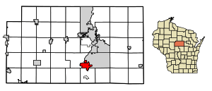
Location of Mosinee in Marathon County, Wisconsin.
|
|
| Country | United States |
| State | Wisconsin |
| County | Marathon |
| Incorporated (village) | 1889 |
| Incorporated (city) | April 7, 1931 |
| Area | |
| • Total | 7.11 sq mi (22.59 km2) |
| • Land | 7.86 sq mi (20.01 km2) |
| • Water | 0.87 sq mi (2.24 km2) |
| Population
(2020)
|
4,452 |
| • Density | 518.33/sq mi (200.13/km2) |
| Time zone | UTC-6 (Central (CST)) |
| • Summer (DST) | UTC-5 (CDT) |
| ZIP code |
54455
|
| Area code(s) | 715 & 534 |
| FIPS code | 55-54500 |
Mosinee is a city in Marathon County, Wisconsin. It is part of the Wausau, Wisconsin Metropolitan Area. In 2020, about 4,452 people lived there.
Contents
History of Mosinee
Early Days and Name
The land where Mosinee now stands was once home to Native American tribes. These included the Ojibwe, Potawatomi, and Menominee people. The name "Mosinee" comes from a word meaning "Cold Country."
In 1836, a white settler named John L. Moore built the first sawmill here. This started the lumber industry. The town was first called Little Bull Falls. In 1857, it was renamed Mosinee to honor an Ojibwe chief.
From Lumber to Paper
For many years, cutting down trees for lumber was the main business. But by the early 1900s, most of the forests were gone. The lumber industry ended, but the paper industry quickly took its place.
The Mock Communist Invasion
On May 1, 1950, something unusual happened in Mosinee. Local people pretended to be Communist invaders. This was part of a big event put on by the American Legion. It was meant to show what life might be like under Communist rule.
During this "invasion," the mayor and police chief were "captured." Roadblocks were set up, and the library was "purged." Even local restaurants served special "Russian" food. It was a dramatic play for the whole town.
Sadly, the mayor, Ralph E. Kronenwetter, had a heart attack during the event. He passed away five days later. A local minister also died shortly after. These events were a sad coincidence during the mock invasion.
Geography of Mosinee
Mosinee is located in central Wisconsin. It covers an area of about 8.54 square miles (22.12 square kilometers). Most of this area is land, with some water.
People of Mosinee
| Historical population | |||
|---|---|---|---|
| Census | Pop. | %± | |
| 1880 | 201 | — | |
| 1890 | 427 | 112.4% | |
| 1900 | 657 | 53.9% | |
| 1910 | 482 | −26.6% | |
| 1920 | 1,161 | 140.9% | |
| 1930 | 1,229 | 5.9% | |
| 1940 | 1,361 | 10.7% | |
| 1950 | 1,453 | 6.8% | |
| 1960 | 2,067 | 42.3% | |
| 1970 | 2,395 | 15.9% | |
| 1980 | 3,015 | 25.9% | |
| 1990 | 3,820 | 26.7% | |
| 2000 | 4,063 | 6.4% | |
| 2010 | 3,988 | −1.8% | |
| 2020 | 4,452 | 11.6% | |
| U.S. Decennial Census | |||
In 2010, about 3,988 people lived in Mosinee. The city had 1,660 households. About 32% of households had children under 18. Most residents were White, with smaller groups of other races. The average age in the city was about 39 years old.
Getting Around Mosinee
Central Wisconsin Airport
The Central Wisconsin Airport (CWA) is very close to Mosinee. It's about 2 miles (3.2 km) southeast of the city center. This airport offers flights for travelers and also handles private planes.
In 2018, the airport hosted a large political rally. Many people came to attend the event.
Learning in Mosinee
Joseph Dessert Library
The Joseph Dessert Library is an important part of Mosinee's history. Joseph Dessert came to the area in 1844. He built and provided a free library for the community. It opened on February 11, 1899.
The building was used for many things besides books. It was a post office, a village hall, and even a school. Community events like dances and plays were held there. Today, it is part of the Marathon County Public Library system. The library building is listed on the National Register of Historic Places. This means it is a special historical site.
Mosinee School District
Students in Mosinee attend schools within the Mosinee School District.
Famous People from Mosinee
- John Altenburgh, a Jazz/Blues musician
- Cole Caufield, an NHL hockey player
- Kevin Cywinski, a NASCAR driver
- Willis F. La Du, a state legislator
- Kole Heckendorf, a football player
- William A. Kasten, a state legislator
- Sebastian Kronenwetter, a pioneer and state legislator
- Thomas J. Springer, a state legislator
- Henry M. Thompson, a state legislator
See also
 In Spanish: Mosinee (Wisconsin) para niños
 | Aurelia Browder |
 | Nannie Helen Burroughs |
 | Michelle Alexander |


