Motley, Queensland facts for kids
Quick facts for kids MotleyQueensland |
|||||||||||||||
|---|---|---|---|---|---|---|---|---|---|---|---|---|---|---|---|

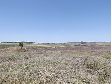
Fields along Toowoomba Cecil Plains Road, 2014
|
|||||||||||||||
| Population | 10 (2021 census) | ||||||||||||||
| • Density | 1.7/km2 (4.4/sq mi) | ||||||||||||||
| Postcode(s) | 4356 | ||||||||||||||
| Area | 6.0 km2 (2.3 sq mi) | ||||||||||||||
| Time zone | AEST (UTC+10:00) | ||||||||||||||
| LGA(s) | Toowoomba Region | ||||||||||||||
| State electorate(s) | Condamine | ||||||||||||||
|
|||||||||||||||
Motley is a small rural area, also called a locality, located in the Toowoomba Region of Queensland, Australia. It is a very quiet place with few people living there. In 2021 census, only 10 people called Motley home.
Where is Motley?
Motley is found in a region known as the Darling Downs. This area is famous for its wide, flat plains and rich farming land.
A main road, the Toowoomba–Cecil Plains Road, runs along the northern edge of Motley. This road helps connect Motley to other nearby towns and areas.
A Look at Motley's Past
Motley got its name from an old railway station. This station was named on August 5, 1915, by the Queensland Railways Department. The name came from the local parish, which is a type of land division.
For a short time, Motley also had its own school. Motley State School opened its doors on August 14, 1922. However, it closed down just a few years later on July 14, 1936.
 | Kyle Baker |
 | Joseph Yoakum |
 | Laura Wheeler Waring |
 | Henry Ossawa Tanner |


