Mount Tyson, Queensland facts for kids
Quick facts for kids Mount TysonQueensland |
|||||||||||||||
|---|---|---|---|---|---|---|---|---|---|---|---|---|---|---|---|

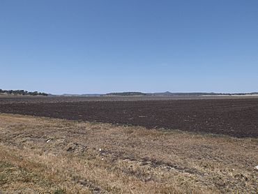
Fields along Toowoomba Cecil Plains Road, 2014
|
|||||||||||||||
| Population | 280 (2021 census) | ||||||||||||||
| • Density | 3.65/km2 (9.5/sq mi) | ||||||||||||||
| Postcode(s) | 4356 | ||||||||||||||
| Area | 76.8 km2 (29.7 sq mi) | ||||||||||||||
| Time zone | AEST (UTC+10:00) | ||||||||||||||
| Location |
|
||||||||||||||
| LGA(s) | Toowoomba Region | ||||||||||||||
| State electorate(s) | Condamine | ||||||||||||||
| Federal Division(s) | Groom | ||||||||||||||
|
|||||||||||||||
Mount Tyson is a small country town in the Toowoomba Region of Queensland, Australia. It is known for its farming areas. In 2021, about 280 people lived in Mount Tyson.
Contents
Exploring Mount Tyson's Location
Mount Tyson is located in an area called the Darling Downs. This is a rich farming region in Queensland. The town is about 37 kilometers (23 miles) west of the city of Toowoomba.
A main road, the Toowoomba–Cecil Plains Road, runs along part of the town's northern edge.
Mount Tyson is also home to two mountains:
- Mount Edgecombe, which is 412 meters (1,352 feet) high.
- Mount Tyson, which is 481 meters (1,578 feet) high.
A Look Back at Mount Tyson's History
The town of Mount Tyson got its name from its railway station. The railway station was named after the nearby mountain, Mount Tyson. People believe the mountain was named after James Tyson, who was a very successful farmer and a politician in Queensland.
Schools and Services
Mount Tyson Provisional School first opened its doors on 18 April 1904. It started with 35 students. Minnie Fletcher was the first teacher. The school became Mount Tyson State School on 1 January 1909. Over the years, the school grew bigger with new buildings added in 1916, 1949, 1963, 1973 (for a library), and 1996 (for Prep students). The school celebrated its 100th birthday in 2004!
The Mount Tyson Post Office opened around 1917. Before that, there was a smaller mail service since 1904.
From 1914 to 1994, a railway line called the Cecil Plains railway line helped connect the town to other places.
Community Buildings
St Philip's Anglican Church was officially opened on 13 October 1907. Later, another church building from Springside was moved to Mount Tyson. It was used for Sunday school and then became a community hall. St Philip's church closed around 2014.
The Mount Tyson Methodist Church was built in 1907. It could hold 100 people, but it has since been taken down.
Mary Immaculate Catholic Church was built in 1958. It is a timber church.
In 1991, Mount Tyson won a special award called the Australian Tidy Town Awards. This award is given to towns that are very clean and well-kept.
People of Mount Tyson
In 2016, the population of Mount Tyson was 285 people. By 2021, the number of people living in Mount Tyson was 280.
Learning and Education
Mount Tyson State School is a government primary school for students from Prep to Year 6. It is located on Main Street. In 2017, the school had 58 students. In 2018, it had 55 students.
There are no high schools in Mount Tyson. Students who want to go to secondary school usually attend Pittsworth State High School in Pittsworth or Oakey State High School in Oakey.
Town Facilities
The Toowoomba Regional Council provides library services to Mount Tyson. A special mobile library van visits the town on the second and fourth Tuesday of every month.
Mary Immaculate Catholic Church is located at 45 Main Street.
Famous People from Mount Tyson
- Sir Alan Roy Fletcher was a well-known person from the area. He was the head of the Pittsworth Shire Council and also a politician who represented the area in the Queensland Parliament.
 | Delilah Pierce |
 | Gordon Parks |
 | Augusta Savage |
 | Charles Ethan Porter |


