Mount Adair facts for kids
Quick facts for kids Mount Adair |
|
|---|---|

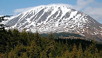
Southeast aspect from Primrose Trail
|
|
| Highest point | |
| Elevation | 5,178 ft (1,578 m) |
| Prominence | 2,778 ft (847 m) |
| Isolation | 4.1 mi (6.6 km) |
| Geography | |
| Location | Chugach National Forest Kenai Peninsula Borough Alaska, United States |
| Parent range | Kenai Mountains |
| Topo map | USGS Seward B-7 |
Mount Adair is a really tall mountain in Alaska, USA. It's part of the Kenai Mountains and has two main peaks, like two bumps on its top! The eastern peak is a bit taller than the western one. This amazing mountain is located in the Chugach National Forest. It's not too far from other cool places like Mount Ascension and Seward, Alaska. All the rain and snow that falls on Mount Adair eventually flows into Kenai Lake. People have known about Mount Adair by its local name since 1951.
Understanding Mount Adair's Climate
Mount Adair is in a subarctic climate zone. This means it has very long, cold, and snowy winters. The summers are usually mild, not too hot.
Winter Weather on the Mountain
During winter, temperatures can drop really low, sometimes below -20 °C (which is -4 °F). With the wind, it can feel even colder, like -30 °C (-22 °F) or less!
Forests Around Mount Adair
Because of this cold climate, you'll find forests of spruce and hemlock trees on the lower parts of the mountain. These trees are tough and can handle the chilly weather.
 | Lonnie Johnson |
 | Granville Woods |
 | Lewis Howard Latimer |
 | James West |


