Mount Ascension facts for kids
Quick facts for kids Mount Ascension |
|
|---|---|

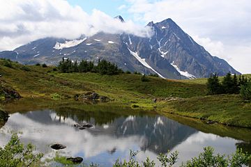
Northeast aspect, summit on right
|
|
| Highest point | |
| Elevation | 5,710 ft (1,740 m) |
| Prominence | 4,810 ft (1,470 m) |
| Isolation | 9.07 mi (14.60 km) |
| Geography | |
| Location | Chugach National Forest Kenai Peninsula Borough Alaska, United States |
| Parent range | Kenai Mountains |
| Topo map | USGS Seward B-7 |
| Climbing | |
| First ascent | 1968 |
| Easiest route | Mountaineering |
Mount Ascension is a tall mountain in Alaska, standing at about 5,710 feet (1,740 meters) high. It is part of the Kenai Mountains on the Kenai Peninsula. This mountain is located inside the Chugach National Forest.
Mount Ascension is about 6.8 miles (11 km) south of Mount Adair. It is also 3.5 miles (5.6 km) north of Resurrection Peaks. The city of Seward, Alaska is about 10 miles (16 km) to the south. This peak is very close to where the Resurrection River flows into Resurrection Bay.
The name "Resurrection" is used a lot for places nearby. So, the name "Ascension" is a similar idea. The Mountaineering Club of Alaska suggested the name Mount Ascension in 1968. The United States Geological Survey officially adopted it in 1969.
You can reach the mountain using the Lost Lake Trail. But you need special mountaineering skills to get to the very top. On a clear day, you can see the huge Harding Icefield from the summit. The first people to climb Mount Ascension were John Vincent Hoeman and his wife, Dr. Grace (Jansen) Hoeman. They reached the top on October 6, 1968.
Weather at Mount Ascension
Mount Ascension has a subarctic climate. This means it has very long, cold, and snowy winters. The summers are usually mild.
Temperatures can drop below -20 °C (-4 °F). With the wind, it can feel even colder, sometimes below -30 °C (-22 °F). Because of this climate, you can find forests of spruce and hemlock trees on the lower parts of the mountain.
 | William Lucy |
 | Charles Hayes |
 | Cleveland Robinson |


