Mount Adams (Colorado) facts for kids
Quick facts for kids Mount Adams |
|
|---|---|

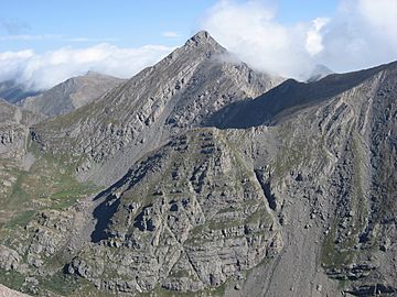
View of Mount Adams from the south
|
|
| Highest point | |
| Elevation | 13,937 ft (4,248 m) |
| Prominence | 871 ft (265 m) |
| Isolation | 1.86 mi (2.99 km) |
| Geography | |
| Location | Custer and Saguache counties, Colorado, United States |
| Parent range | Sangre de Cristo Range, Crestones |
| Topo map | USGS 7.5' topographic map Horn Peak, Colorado |
| Climbing | |
| Easiest route | Scramble Class 3 |
Mount Adams is a very tall mountain peak in the Rocky Mountains of North America. It is part of the Crestones group within the Sangre de Cristo Range. This mountain is located in Colorado, United States.
Where is Mount Adams?
Mount Adams stands tall in the Sangre de Cristo Wilderness. This wilderness area is a protected natural space. The mountain is about 8.2 kilometers (5.1 miles) east of the Town of Crestone. It sits on the border between two counties in Colorado: Custer County and Saguache County. It also separates two large national forests: San Isabel National Forest and Rio Grande National Forest.
How Tall is Mount Adams?
Mount Adams is a very high peak, reaching 13,937 feet (4,248 meters) above sea level. Mountains that are over 13,000 feet tall are sometimes called "thirteeners." This makes Mount Adams one of the many impressive high peaks in Colorado.
Climbing Mount Adams
Climbing Mount Adams is an exciting adventure for experienced hikers. The easiest way to climb it is usually a "Class 3" route. This means you'll need to use your hands for balance and sometimes for climbing up rocky sections, but you won't need special climbing gear like ropes.
There are a few main ways to reach the top:
- West Ridge: This route starts near Willow Lake.
- Southeast Face: You can approach this side from the Horn Creek Trailhead.
- Northwest Ridge: This path begins near the South Crestone Lake Trailhead.
 | John T. Biggers |
 | Thomas Blackshear |
 | Mark Bradford |
 | Beverly Buchanan |


