
Mount Aragats facts for kids
Quick facts for kids Mount Aragats |
|
|---|---|
 |
|
| Highest point | |
| Elevation | 4,090 m (13,420 ft) |
| Prominence | 2,143 m (7,031 ft) |
| Listing | Country high point Ultra |
| Geography | |
| Location | Aragatsotn Province and Shirak Province, Armenia |
| Country | |
| Parent range | Lesser Caucasus |
| Geology | |
| Age of rock | Holocene |
| Mountain type | Stratovolcano |
| Last eruption | Unknown |
| Climbing | |
| First ascent | July 1843 Khachatur Abovian and Moritz Wagner |
Mount Aragats is a huge volcano in Armenia. It has four main peaks. The highest peak, called the northern summit, is about 4,090 meters (13,419 feet) tall. This makes it the tallest point in Armenia and the entire Lesser Caucasus mountain range.
Aragats is also one of the highest mountains in the wider Armenian Highlands. Some people say it's the second highest, after Mount Ararat. Others rank it third or fourth, depending on how they define the region.
Contents
About Mount Aragats
Mount Aragats is surrounded by rivers and plains. The Kasagh River is to its east, and the Akhurian River is to its west. To the south is the Ararat plain, and to the north is the Shirak plain.
The mountain covers a large area, about 6,000 square kilometers (2,300 square miles). This is about one-fifth of Armenia's total land. A big part of the mountain, about 944 square kilometers (364 square miles), is higher than 2,000 meters (6,562 feet).
The Four Peaks
Mount Aragats is special because it has four peaks. These peaks form a circle around a volcanic crater. The northern peak is the highest. The other peaks are the western, southern, and eastern peaks.
When Did Aragats Form?
Aragats is a stratovolcano. This means it's a cone-shaped volcano built up by many layers of hardened lava, ash, and rocks. Scientists believe it formed during the Holocene period, which is the current geological age. Its last eruption is unknown.
First Climbers
The first recorded climb to the top of Mount Aragats was in July 1843. It was climbed by Khachatur Abovian and Moritz Wagner. Climbing Aragats is a popular activity for hikers today.
Related pages
Images for kids
-
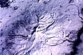
Mount Aragats, topographic representation
-
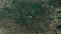
Aerial view of Aragats: a 2001 photo from the International Space Station
-
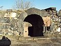
Arshakid Mausoleum.
-
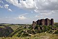
Amberd and Vahramashen Church.
-

Tegher Monastery.
-
Alphabet park.
-
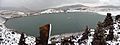
Lake Kari and the Aragats Cosmic Ray Research Station (in the background).
-

Obverse side of the 10,000 Armenian dram banknote depicting Aragats and poet Avetik Isahakyan.


.png)
See also
 In Spanish: Aragats para niños
