
Shirak Province facts for kids
Quick facts for kids
Shirak
Շիրակ
|
|
|---|---|

Location of Shirak within Armenia
|
|
| Country | Armenia |
| Capital and largest city |
Gyumri |
| Area | |
| • Total | 2,680 km2 (1,030 sq mi) |
| Area rank | 6th |
| Population
(2011)
|
|
| • Total | 251,941 |
| • Rank | 2nd |
| • Density | 94.01/km2 (243.5/sq mi) |
| Time zone | AMT (UTC+04) |
| Postal code |
2601–3126
|
| ISO 3166 code | AM-SH |
| FIPS 10-4 | AM07 |
| HDI (2017) | 0.753 high · 4th |
| Website | Official website: http://shirak.mtad.am/ |
Shirak is a province (called a marz) in Armenia. It is in the northwest part of the country. Shirak shares borders with Turkey to the west and Georgia to the north. The capital and largest city of Shirak is Gyumri.
The land in Shirak is very diverse. You can find dry, semi-desert areas and also high mountain meadows. In the south, tall grassy plains meet mountain areas. These areas are bright green in spring and turn reddish-brown in summer. The province is served by the Shirak International Airport in Gyumri.
Contents
What Does Shirak Mean?
Shirak Province gets its name from an old area called Shirak. This area was part of the historic Ayrarat province in Ancient Armenia. The noble Kamsarakan family ruled this region from the 3rd to the 8th centuries.
Exploring Shirak's Geography

Shirak Province is located in the northwestern part of Armenia. It covers an area of 2,680 square kilometers. This is about 9% of Armenia's total land. Shirak borders Lori Province to the east and Aragatsotn Province to the south. To the west, it borders the Kars Province of Turkey. To the north, it borders the Samtskhe-Javakheti region of Georgia.
Historically, this area was mostly the Shirak canton of the Ayrarat province in Ancient Armenia.
Mountains and Plains of Shirak
Shirak has two main land features. In the north, there is the Ashotsk Plateau. This plateau is between 1,900 and 2,100 meters high. In the center and south, you'll find the Shirak Plain. This plain is between 1,400 and 1,800 meters high.
Large plains in the province are surrounded by mountains. The Bazum and Pambak mountains are to the east. The Javakheti Range and Yeghnakhagh mountains are to the north. The Aragats mass is to the south. The Akhurian River is to the east. It separates Shirak from the Kars Province in Turkey.
Water Resources and Climate

The Akhurian River and its reservoir are the main water sources in Shirak. Lake Arpi is in the northwest of the province. It is the only lake here. This area is protected by the government. It is known as the Lake Arpi National Park.
Shirak is rich in natural resources. You can find tufa, pumice, and limestone here.
The climate in Shirak has very cold, snowy winters. Summers are mild and pleasant. The area gets about 700 millimeters of rain each year.
Images for kids
-
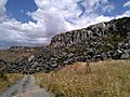
Vahramaberd fortress, 8th c. BC
-
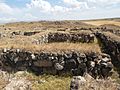
Orontid settlement of the 5th-2nd centuries BC
-
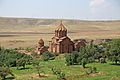
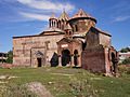
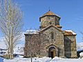
Marmashen Monastery
-
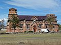
Saint Paul and Peter Church of Bardzrashen, flourished under the Zakarids
-
Sev Berd or the Black Fortress near Gyumri, built during the 1830s by the Russians in response to the Russo-Turkish War of 1828–1829
-
Saint Arsenije Russian Church, Gyumri
-
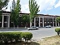
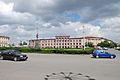
Shirak Province administration in Gyumri
-
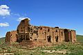
Yererouk Basilica of the 4th-5th centuries, is one of the earliest samples of Armenian church architecture
-
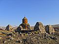
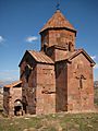
Harichavank Monastery, 8th century
-

Shirak Airport
-

Gyumri Railway Station
-
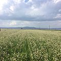
Buckwheat fields in Shirak
-
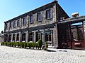
The Gyumri Brewery
-
The Progress University in Gyumri
-

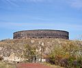
Gyumri City Stadium
-
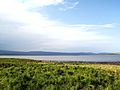
Lake Arpi and its National park
-
Tiravor Church in Mayisyan, 7th century
-
Lmbatavank near Artik, 7th century
-
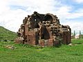
The remains of Makaravank Church of Pemzashen, 10th century
-
Aghin village


See also
 In Spanish: Provincia de Shirak para niños
