Aragatsotn Province facts for kids
Quick facts for kids
Aragatsotn
Արագածոտն
|
|
|---|---|

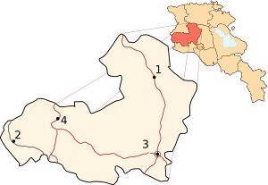
Location of Aragatsotn within Armenia
|
|
| Country | Armenia |
| Capital | Ashtarak |
| Area | |
| • Total | 2,753 km2 (1,063 sq mi) |
| Area rank | 5th |
| Population
(2002)
|
|
| • Total | 126,278 |
| • Rank | 9th |
| • Density | 45.869/km2 (118.801/sq mi) |
| Time zone | UTC+04 |
| • Summer (DST) | UTC+05 |
| Postal code |
0201-0514
|
| ISO 3166 code | AM.AG |
| FIPS 10-4 | AM01 |
| Website | aragatsotn.gov.am |
Aragatsotn is a special region, like a state or province, in the country of Armenia. It's located in the western part of Armenia. The main city and capital of Aragatsotn is Ashtarak. The name "Aragatsotn" actually means "a foot of Aragats", which is a very tall mountain nearby.
Long ago, during the time of the Arsacid Dynasty and the ancient Kingdom of Armenia, this area was part of a larger province called Ayrarat. A noble family known as the Amatuni family ruled this region. Their main city was Oshakan.
Aragatsotn shares its western border with the country of Turkey. The province is made up of 3 urban areas (cities or towns) and 111 rural areas (villages).
Contents
Exploring Aragatsotn Province
Aragatsotn is a fascinating place with a mix of history, nature, and modern life. It's known for its beautiful landscapes and ancient buildings.
Geography and Nature
Aragatsotn is named after Mount Aragats, which is the highest mountain in Armenia. This mountain is actually an extinct volcano. Its peaks are often covered in snow. The province has many rivers and streams that flow down from the mountains.
Mountains and Lakes
The landscape includes high mountains, green valleys, and even some volcanic areas. Lake Kari is a beautiful lake located high up on Mount Aragats. It's a popular spot for visitors. The Arteni mountains are another notable feature, adding to the varied terrain.
Climate
The weather in Aragatsotn changes a lot depending on how high up you are. In the lower areas, summers are warm and sunny. Winters can be cold, especially in the mountains, with lots of snow. This makes it a great place for different kinds of plants and animals.
History and Culture
Aragatsotn has a very long and rich history. Many ancient churches, monasteries, and fortresses can be found here. These buildings tell stories of Armenia's past.
Ancient Structures
- Churches and Monasteries: You can find very old churches like the Holy Cross Basilica of Kasagh from the 4th century. The ruins of the Saint Paul and Peter Church in Zovuni also date back to the 4th and 5th centuries. Later, in the 7th century, the impressive Cathedral of Talin was built.
- Fortresses: The Dashtadem Fortress from the 9th century and the Amberd fortress are amazing examples of old defensive structures. They show how people protected their lands long ago.
- Monasteries: The Saint Christopher Monastery from the 7th century, Yeghipatrush Church from the 10th century, Saghmosavank Monastery from the 13th century, and Saint Gevorg Monastery of Mughni from the 14th century are all important historical sites.
Armenian Alphabet Park
A unique place in Aragatsotn is the Armenian Alphabet Park. It's a monument dedicated to the Armenian alphabet. Each letter is carved into a large stone, making it a fun and educational place to visit.
Economy and Life
The people of Aragatsotn mostly work in farming and raising animals. The fertile lands and mountain pastures are good for agriculture.
Farming and Food
Many people grow crops like grapes and grains. There are also bakeries that use traditional methods, like the "Gntunik" bakery in Aparan, which uses a special oven called a tandoor. The region is also known for its wineries, like the "Golden Grape ArmAs" winery.
Science and Technology
Aragatsotn is not just about history and farming. It's also a center for science. The Byurakan Observatory is a famous place where scientists study stars and space. There's also an institute in Ashtarak with a large radio telescope used for scientific research.
Sports and Recreation
Football is a popular sport, and there are stadiums like the one in Parpi village. The beautiful natural scenery also makes Aragatsotn a great place for outdoor activities like hiking and exploring.
Images for kids
-
"Gntunik" bakery in Aparan using the traditional tandoor
-
Mount Aragats and Lake Kari at the Aragats Alpine Sanctuary
See also
 In Spanish: Aragatsotn para niños
 | George Robert Carruthers |
 | Patricia Bath |
 | Jan Ernst Matzeliger |
 | Alexander Miles |


