Mount Franklin (Victoria) facts for kids
Quick facts for kids Mount Franklin(Willambeparamal) |
|
|---|---|

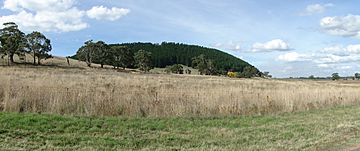
View from Highway
|
|
| Highest point | |
| Elevation | 648 metres (2,126 ft) |
| Prominence | 270 m (890 ft) |
| Geography | |
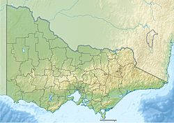
Mount Franklin (called Willambeparamal by the Djadjawurrung people) is an extinct volcano in Victoria, Australia. It is located about 10 km north of Daylesford. A road winds up its slopes, which are covered with pine trees. This road leads into a large, flat crater called a caldera. On the rim of the crater, you'll find a fire lookout, a parking area, and a picnic spot.
The flat top of Mount Franklin is now a free camping ground. It has a central grassy area surrounded by campsites. There are picnic tables and wood fire barbecues for visitors to use. You can set up tents or park caravans and RVs here. A toilet block and a water tank (for non-drinking water) are near the entrance.
Mount Franklin is an important landmark in the Hepburn Shire. It is part of the Mount Franklin Reserve, which is looked after by Parks Victoria.
Contents
The Story of Mount Franklin
Mount Franklin was formed by a volcanic eruption about 470,000 years ago. It is a great example of a scoria cone that has been "breached." This means part of its side broke open. The road you drive up now goes through this opening on the south-eastern rim. Scientists believe this opening was made when lava flowed out and broke through the rim. The crater (caldera) here is one of the deepest in the central highlands area. The volcano is not active anymore.
The volcanic eruptions might have been seen by the Dja Dja Wurrung Aboriginal people. They called this land the ‘smoking grounds.’ The Aboriginal clan living around Mount Franklin was the Gunangara Gundidj. They called the mountain Willambeparamal, which means home of the emus. Mount Franklin and the area around it were very important for Aboriginal ceremonies and gatherings.
Lava from Mount Franklin and other volcanoes in the area filled valleys. This lava covered up streams that contained gold. These became known as ‘deep leads’ during the gold mining era.
Early European Settlement
In 1855, the land around Mount Franklin was described as having many trees like box and stringybark. News of fertile land brought many settlers, who called the mountain "Jem Crow Hill." Charles Joseph La Trobe, who was a superintendent for the Port Phillip District, named the mountain after Sir John Franklin. They climbed the hill together in December 1843.
In 1840, the government set aside Mount Franklin and the surrounding area. This was for the Loddon Aboriginal Protectorate Station. This station was meant to help Aboriginal people, but it was a difficult place for them.
In 1852, during the Victorian gold rush, gold was found nearby. This put more pressure on the protectorate station. It was made smaller and eventually moved.
Gold Mining at Mount Franklin
Around 1865, people discovered a "deep lead" of gold inside Mount Franklin. Mining this deep gold was hard at first. It wasn't until the late 1870s that the Franklinford Gold Mining Company started mining a lot of gold at Mount Franklin. Other companies like the Mount Franklin Estate Gold Mining Company, Shakespeare, and Great Western also found gold in the 1880s. However, by the late 1880s, deep lead mining in the area had stopped.
As the easy-to-find gold (alluvial gold) ran out, miners looked for gold deeper underground. This gold was formed by lava flows from the Newer Volcanic period. One company had a mining lease at the eastern base of Mount Franklin.
Mount Franklin as a Reserve
In 1866, the crater of Mount Franklin was set aside as a recreation area. The rest of the land became a State forest. Because there was a high demand for land, two parts of the reserve were sold for farming. This made people want to protect Mount Franklin permanently.
During the 1870s and 1880s, natural bushland became popular places for recreation, more so than formal parks. In 1875, people asked the Victorian government to protect all the land at Mount Franklin for public use. The next year, 157 acres were officially reserved. In 1891, the Shire of Mount Franklin was given full control of the reserve.
From the 1880s, parts of the reserve were rented out for grazing animals. This brought in money for the people managing the reserve. By the 1920s, rabbits were a big problem. Still, the crater was a popular spot for picnics. Mount Franklin was promoted as a beautiful local place, easy to reach from Daylesford and Hepburn Springs mineral springs resort. A shelter and a rainwater tank were built.
In 1880, the railway reached Daylesford. This made it easier for people from Melbourne to visit places like Mount Franklin for a day trip.
In 1944, a big bushfire destroyed most of the native plants on the mountain. After the fire, the inner and outer slopes of the crater were planted with non-native trees, mostly conifers (like pine trees). This was to stop soil from washing away and to make money from selling the timber. The crater itself was planted with trees like silver birch, white poplar, Sycamore, and Sequoia sempervirens (Californian Redwoods).
Not everyone liked these changes. Edgar Morrison said that when the Forest Commission planted these "foreign" trees, the old mountain "resented the indignity."
In 1955, 145 acres were made into a permanent forest, managed by the Shire of Daylesford and Glenlyon. Within this reserve, eight acres were set aside for recreation, including an entrance gate and a new road. This new road made the mountain easier to get to. This happened at the same time that more people owned cars in the 1950s, and rules about petrol were lifted after the war.
In 1972, the Department of Crown Lands and Survey took over managing the mountain. In 1977, Mount Franklin became part of the new Hepburn Regional Park. It was then managed by the Forest Commission of Victoria.
'Mount Franklin' Mineral Spring
Mineral springs were first noticed in 1864. Bottling of mineral water began in places like Ballan and Hepburn. Their flow rates were measured during the gold mining era and again in 1910.
Until 1986, the company Coca-Cola Amatil bottled mineral water from Gilmore's (Limestone Creek) Mineral Spring. This spring was about 7 km north of Mount Franklin. In 1910, a report said one part of the spring flowed at 726 litres per day. Other parts kept a water hole full. The water tasted good and had a lot of gas bubbling up. The spring water left behind minerals like limestone and iron oxide over about an acre of land. This deposit is still forming.
Coca Cola, which had permission to take 35 megalitres of water, renamed the spring ‘Mount Franklin’ to help sell their product. They took out over 15 megalitres of water at their busiest time. The ‘Mount Franklin’ brand is still very famous and profitable for the company. However, no water has been taken from the original spring site for about 35 years. The original spring itself was damaged, and the structures there are now overgrown and forgotten.
Even though Coca Cola Amatil still owns the ‘Mount Franklin’ brand, they stopped taking water from the original spring in 1985/1986. The company's advertisements do not mention the original spring or where the water for the brand comes from now. The company continues to take water from other springs in the area, including at Eganstown and Wheatsheaf.
See also
 | Delilah Pierce |
 | Gordon Parks |
 | Augusta Savage |
 | Charles Ethan Porter |


