Mount Gay-Shamrock, West Virginia facts for kids
Quick facts for kids
Mount Gay-Shamrock, West Virginia
|
|
|---|---|

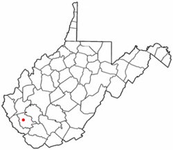
Location of Mount Gay-Shamrock, West Virginia
|
|
| Country | United States |
| State | West Virginia |
| County | Logan |
| Area | |
| • Total | 7.56 sq mi (19.58 km2) |
| • Land | 7.55 sq mi (19.55 km2) |
| • Water | 0.01 sq mi (0.03 km2) |
| Elevation | 668 ft (204 m) |
| Population
(2010)
|
|
| • Total | 1,779 |
| • Density | 236/sq mi (91.0/km2) |
| Time zone | UTC-5 (Eastern (EST)) |
| • Summer (DST) | UTC-4 (EDT) |
| ZIP Codes |
25637 (Mount Gay)
25601 (Logan) |
| Area code(s) | 304 |
| FIPS code | 54-56342 |
| GNIS feature ID | 2389511 |
Mount Gay-Shamrock is a special kind of community called a census-designated place (CDP) in Logan County, West Virginia, United States. A CDP is like a town, but it doesn't have its own local government.
In 2020, about 1,360 people lived in Mount Gay-Shamrock. The number of people living here has gone down a bit since 2010, when there were 1,779 residents.
This area includes several smaller communities. Some of these are Mount Gay, Shamrock, Black Bottom, Whites Addition, Lintz Addition, Thompson Town, Hedgeview, Ridgeview, Logan Heights, Cora, and Whitman Junction. The Mount Gay post office first opened in 1916.
Contents
Geography and Location
Mount Gay-Shamrock is located in the western part of Logan County. The village of Mount Gay is in the eastern section of the CDP. It sits where two creeks, Island Creek and Copperas Mine Fork, meet. The village of Shamrock is just west of Mount Gay, in the Copperas Mine Fork valley.
Roads and Travel
The communities within Mount Gay-Shamrock follow the valleys of Island Creek, Copperas Mine Fork, and Mud Fork. To the east, Mount Gay-Shamrock is next to the city of Logan, which is the main town in the county. To the west, U.S. Route 119, a big four-lane highway, separates Mount Gay-Shamrock from Verdunville.
West Virginia Route 73 is the main road that goes through the CDP. It follows the Mud Fork valley and connects to US-119 in the west and Logan in the east. West Virginia Route 44 goes south from Mount Gay, following the Island Creek valley. An older version of US Highway 119 also runs through the Copperas Mine Fork valley, joining the current US-119 at Holden.
Area and Waterways
The United States Census Bureau says that Mount Gay-Shamrock covers a total area of about 19.6 square kilometers (about 7.6 square miles). Only a very small part of this area, about 0.03 square kilometers (0.01 square miles), is water. The entire area is part of the Island Creek watershed. This means that all the water in the area flows into Island Creek, which then flows into the Guyandotte River in Logan. The Guyandotte River eventually leads north to the Ohio River.
People and Population
Let's look at the people who live in Mount Gay-Shamrock, based on information from the census of 2000.
Population Details
In 2000, there were 2,623 people living in the CDP. These people lived in 1,065 households, and 726 of these were families. The population density was about 219 people per square mile. There were 1,216 homes in the area.
Most of the people living in Mount Gay-Shamrock were White (about 90.43%). About 8.27% were African American. Smaller numbers of people identified as Native American, Asian, or Pacific Islander. Some people were from other races or from two or more races. About 0.38% of the population identified as Hispanic or Latino.
Households and Families
Out of the 1,065 households, about 27.9% had children under 18 living with them. Nearly half (48.2%) were married couples living together. About 14.9% of households had a female head of household with no husband present. About 31.8% of households were not families.
Almost 28.6% of all households were made up of people living alone. About 11.2% of these were people aged 65 or older living by themselves. On average, there were 2.46 people in each household and 3.02 people in each family.
Age and Income
The population of Mount Gay-Shamrock was spread out by age. About 22.6% of the people were under 18 years old. About 9.2% were between 18 and 24. The largest group, 27.7%, was between 25 and 44 years old. About 26.5% were between 45 and 64, and 14.0% were 65 years or older. The average age was 40 years.
The median income for a household in the CDP was $18,975. For families, the median income was $22,946. This means that half the households earned more than this amount, and half earned less. The average income per person in the CDP was $12,532. About 29.3% of families and 34.2% of the total population lived below the poverty line. This included 49.0% of those under 18 and 29.0% of those aged 65 or older.
See also
 In Spanish: Mount Gay-Shamrock para niños

