Mount Hancock (New Hampshire) facts for kids
Quick facts for kids Mount Hancock |
|
|---|---|

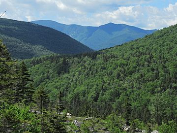
Mt. Hancock viewed from Zealand Notch
|
|
| Highest point | |
| Elevation | 4,403 feet (1,342 m) |
| Prominence | 1,200 ft (370 m) |
| Listing | White Mountain 4000-footers |
| Geography | |
| Location | Grafton County, New Hampshire, U.S. |
| Parent range | White Mountains |
| Topo map | USGS Mount Carrigain |
| South Hancock | |
|---|---|
| Highest point | |
| Elevation | 4,319 ft (1,316 m) NGVD 29 |
| Prominence | 179 ft (55 m) |
| Listing | White Mountain 4000-footers |
Mount Hancock is a mountain located in Grafton County, New Hampshire. It was named after John Hancock (1737–1793). He was an important leader who helped create the United States.
Discover Mount Hancock
Mount Hancock is found on the south side of the Pemigewasset Wilderness. This is a large, wild area in the middle of the White Mountains. The Pemigewasset River actually starts here.
The mountain sits between two famous mountain passes: Franconia Notch and Crawford Notch. Other mountains surround Mount Hancock. To its northeast is Mount Carrigain. To the south, you'll find Mount Huntington. And to the west is Mount Hitchcock.
For a long time, Mount Hancock was very hard to reach. It was one of the most remote peaks in the White Mountains. But then the Kancamagus Highway was built. This road made it much easier for people to visit the mountain.
The Appalachian Mountain Club tracks mountains that are over 4,000 feet (about 1,219 meters) tall. These are called "four-thousand footers." Both Mount Hancock and a peak just south of it are considered "four-thousand footers."
The southern peak is not officially named. However, it rises more than 200 feet (about 61 meters) above the low point that connects it to the taller north peak. This low point is called a "col" or a mountain pass. Because it rises enough, it counts as its own separate mountain.
 | Tommie Smith |
 | Simone Manuel |
 | Shani Davis |
 | Simone Biles |
 | Alice Coachman |

