Zealand Notch facts for kids
Quick facts for kids Zealand Notch |
|
|---|---|

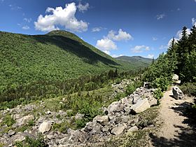
Zeacliff rising over Zealand Notch; north-facing view from the Ethan Pond Trail
|
|
| Elevation | 2,457 ft (749 m) |
| Traversed by | Appalachian Trail |
| Location | Grafton County, New Hampshire, US |
| Range | White Mountains |
| Coordinates | 44°11′51″N 71°29′29″W / 44.1974°N 71.4913°W |
| Topo map | USGS Crawford Notch |
Zealand Notch is a special place in the White Mountains of New Hampshire, United States. It's like a natural gateway or a low spot between two mountains. This beautiful area is found near the edge of the Pemigewasset Wilderness. It's a popular spot for hikers, with trails running right through its center. You'll find cool places like Zealand Pond, Zealand Falls, and the cozy Zealand Falls hut here.
Contents
What is Zealand Notch?
Zealand Notch is a mountain pass, which means it's a lower area between two higher mountains. It sits at an elevation of about 2,457 feet (749 meters) above sea level. This notch is located in the towns of Bethlehem and Lincoln. It's a bit remote, about 2 miles (3.2 km) from the closest road.
How the Notch Was Formed
Like Crawford Notch nearby, Zealand Notch has steep sides and a U-shaped valley. This shape was carved out long ago by glaciers moving through the area. Imagine a giant ice scoop digging out the land!
Rivers and Water Flow
Water from Zealand Notch flows in two different directions.
- To the south, Whitewall Brook flows through the notch. This brook joins the North Fork of the Pemigewasset River. Eventually, this water reaches the Merrimack River and then flows into the Gulf of Maine in the Atlantic Ocean.
- To the north, the Zealand River flows away from the notch. This river eventually meets the Ammonoosuc River. Its water then travels to the Connecticut River, which flows south all the way to Long Island Sound.
Mountains Around the Notch
Zealand Notch is surrounded by impressive mountains.
- To the east, you'll find Whitewall Mountain, which is about 3,405 feet (1,038 meters) tall.
- To the west, there's Zeacliff, a part of Mount Zealand. Zeacliff rises to about 3,600 feet (1,097 meters).
Exploring Zealand Notch: Trails and Sights
Zealand Notch is a fantastic place for hiking and exploring the outdoors. Many trails cross through this area, offering amazing views and natural wonders.
The Appalachian Trail
The famous Appalachian Trail goes right through Zealand Notch. This long-distance hiking trail stretches for thousands of miles across the eastern United States.
- Coming from the west, the Appalachian Trail (which is also called the Twinway trail here) goes down from Zeacliff.
- Hikers pass by Zealand Falls, which is a series of smooth granite ledges with a 50-foot (15-meter) drop.
- The trail then leads to the Zealand Falls Hut, a cozy place for hikers to rest.
- In the center of the notch, the Twinway trail ends. The Appalachian Trail then turns south. It follows the Ethan Pond Trail, which is built on an old railroad path. This trail goes along the side of Whitewall Mountain and continues towards Crawford Notch.
Other Popular Trails
Besides the Appalachian Trail, several other trails help you explore Zealand Notch:
- Zealand Trail: This trail approaches the notch from the north, following the Zealand River.
- Lend-a-Hand Trail: This trail connects Mount Hale to the northwest with the Zealand Falls Hut.
- Zeacliff Trail: For a more challenging hike, this trail goes straight down from the top of Zeacliff to Whitewall Brook and the Ethan Pond Trail.
- A–Z Trail: This trail starts just north of the notch's highest point and heads east towards Crawford Notch.
 | Shirley Ann Jackson |
 | Garett Morgan |
 | J. Ernest Wilkins Jr. |
 | Elijah McCoy |

