Mount Hope, West Virginia facts for kids
Quick facts for kids
Mount Hope, West Virginia
|
||
|---|---|---|

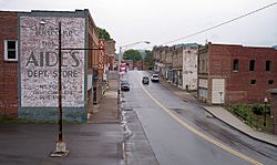
Main Street (West Virginia Route 211) in Mount Hope in 2007
|
||
|
||
| Motto(s):
Gateway to the Summit
|
||

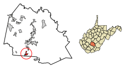
Location of Mount Hope in Fayette County, West Virginia.
|
||
| Country | United States | |
| State | West Virginia | |
| County | Fayette | |
| Area | ||
| • Total | 1.56 sq mi (4.03 km2) | |
| • Land | 1.56 sq mi (4.03 km2) | |
| • Water | 0.00 sq mi (0.00 km2) | |
| Elevation | 1,722 ft (525 m) | |
| Population
(2010)
|
||
| • Total | 1,414 | |
| • Estimate
(2019)
|
1,274 | |
| • Density | 818.24/sq mi (315.97/km2) | |
| Time zone | UTC-5 (Eastern (EST)) | |
| • Summer (DST) | UTC-4 (EDT) | |
| ZIP code |
25880
|
|
| Area code(s) | 304 | |
| FIPS code | 54-56404 | |
| GNIS feature ID | 1543656 | |
Mount Hope is a small city in Fayette County, West Virginia, in the United States. In 2010, about 1,414 people lived there. It's known as the "Gateway to the Summit."
Contents
History of Mount Hope
Early settlers came to Mount Hope to mine coal. Coal mining was a big part of the town's life for about 250 years. However, mining slowed down as new mines opened in the Midwest. It stopped completely during the Great Depression.
Early Settlers and Growth
Before Europeans arrived, Native Americans used this land for many centuries. William Blake, Sr. was the first white settler in the area. He built a hotel called The Old Blake Inn. It provided a place for travelers and coal miners to stay.
Between the 1890s and 1930s, Mount Hope was growing fast. Its population and economy were booming.
The Great Fire and Rebuilding
In 1910, a terrible event happened: The Mount Hope Fire. This fire destroyed most of the town, including The Old Blake Inn. Only a few buildings were left standing.
With help from the community, Mount Hope was rebuilt. A new inn, called "Hotel Mount Hope," was built where the old one stood. It became a popular spot for miners. The town continued to do well for a while.
Decline and Revival Efforts
Sadly, Mount Hope's good times did not last. The population started to shrink when the Great Depression began. The town had a very hard time getting back on its feet.
Hotel Mount Hope closed down. It later reopened as the "New River Hotel." This hotel was for business people traveling through town. It was renovated again and renamed "The Mountainair Hotel," but it eventually closed once more.
Today, Mount Hope's population is still getting smaller. The old hotel was empty for some time. Now, Joyce and Harvey Cottle have bought it. They renamed it "Cottle Mountainair." They are working hard to fix it up and reopen it. They want it to be a place for families and the community to gather.
A local shop called "Heart to Hands The Serendipity Shop" rents a room on the first floor. This shop sometimes hosts events inside the hotel.
The town got its name from the local Mount Hope School.
The Mount Hope Historic District and New River Company General Office Building are important places. They are listed on the National Register of Historic Places.
Geography of Mount Hope
Mount Hope is located at 37°53′33″N 81°10′4″W / 37.89250°N 81.16778°W.
The city covers an area of about 1.33 square miles (3.44 square kilometers). All of this area is land.
The Summit: A National Scout Reserve
A large piece of land, about 10,600 acres (43 square kilometers), was given to the Boy Scouts of America. This land is known as Garden Ground. It was donated by the Bechtel Foundation.
The Boy Scouts developed this land into The Summit: Bechtel Family National Scout Reserve. It is a special place for high-adventure activities. It also hosts the national Scout jamboree.
Population Information
| Historical population | |||
|---|---|---|---|
| Census | Pop. | %± | |
| 1900 | 351 | — | |
| 1910 | 494 | 40.7% | |
| 1920 | 1,989 | 302.6% | |
| 1930 | 2,361 | 18.7% | |
| 1940 | 2,431 | 3.0% | |
| 1950 | 2,588 | 6.5% | |
| 1960 | 2,000 | −22.7% | |
| 1970 | 1,829 | −8.5% | |
| 1980 | 1,849 | 1.1% | |
| 1990 | 1,573 | −14.9% | |
| 2000 | 1,487 | −5.5% | |
| 2010 | 1,414 | −4.9% | |
| 2019 (est.) | 1,274 | −9.9% | |
| U.S. Decennial Census | |||
2010 Census Details
In 2010, the city had 1,414 people living in 626 households. About 362 of these were families.
- The population density was about 1,063 people per square mile (410 per square kilometer).
- There were 737 housing units in the city.
- Most residents were White (77.0%).
- About 18.0% were African American.
- Small numbers of Native American, Asian, and other races also lived there.
- About 1.6% of the population was Hispanic or Latino.
Of the households:
- 30.0% had children under 18 living with them.
- 34.7% were married couples.
- 16.8% had a female head of household with no husband.
- 6.4% had a male head of household with no wife.
- 42.2% were not families.
- 37.1% of households had only one person.
- 12% had someone living alone who was 65 or older.
The average household had 2.26 people. The average family had 2.95 people.
The average age in the city was 37.5 years.
- 24.8% of residents were under 18.
- 14.6% were 65 or older.
- The city was 47.6% male and 52.4% female.
Notable People
- Bob Elkins - An actor who played many different characters.
- John Edward McClung - An old-time musician born here.
- Lonnie Warwick - A professional football player (Linebacker) for the Minnesota Vikings, Atlanta Falcons, and Washington Redskins.
See also
 In Spanish: Mount Hope (Virginia Occidental) para niños
 | Victor J. Glover |
 | Yvonne Cagle |
 | Jeanette Epps |
 | Bernard A. Harris Jr. |


