
Mount Jackson (Montana) facts for kids
Quick facts for kids Mount Jackson |
|
|---|---|

Cloud cap over Mount Jackson
|
|
| Highest point | |
| Elevation | 10,052 ft (3,064 m) |
| Prominence | 3,406 ft (1,038 m) |
| Parent peak | Mount Cleveland |
| Listing | Mountains in Flathead County, Montana |
| Geography | |

Mount Jackson
Location in Montana
|
|
| Parent range | Lewis Range |
| Topo map | USGS Mount Jackson, MT |
Mount Jackson is a tall mountain located in Glacier National Park in Montana, U.S.. It stands at 10,052 feet (3,064 m) high, making it the fourth tallest peak in the park. This impressive mountain is part of the Lewis Range and sits right on the Continental Divide. This means it helps separate rivers that flow to the Atlantic Ocean from those that flow to the Pacific.
You can easily see Mount Jackson and the Jackson Glacier from the Going-to-the-Sun Road. Another large glacier, Harrison Glacier, is found on the mountain's southern side. Mount Jackson has an alpine climate, which means it has very cold, long winters and short, cool summers. Temperatures can drop extremely low, sometimes feeling like −30 °F with the wind!
How Mount Jackson Was Formed
Mount Jackson, like other mountains in Glacier National Park, is made of sedimentary rock. This type of rock forms from layers of sand, mud, and tiny bits of sea creatures that settle at the bottom of ancient seas over millions of years.
The Lewis Overthrust Fault
The rocks that make up Mount Jackson were originally laid down during the Precambrian to Jurassic periods. About 170 million years ago, a huge geological event called the Lewis Overthrust fault began. This fault pushed an enormous slab of older rock over much younger rock.
This massive rock slab was about 3 mi (4.8 km) thick, 50 miles (80 km) wide, and 160 miles (260 km) long. It slid over rocks from the cretaceous period, creating the towering mountains we see today, including Mount Jackson.
Images for kids
-
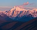
Mt. Jackson from west at sunset
-
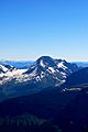
Mount Jackson with Jackson Glacier directly to the left of the mountain
-
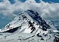
Mount Jackson


