
Mount Cleveland (Montana) facts for kids
Quick facts for kids Mount Cleveland |
|
|---|---|

Mount Cleveland
|
|
| Highest point | |
| Elevation | 10,479 ft (3,194 m) NAVD 88 |
| Prominence | 5,226 ft (1,593 m) |
| Parent peak | Mount Evans |
| Listing |
|
| Geography | |

Mount Cleveland
Location in Montana

Mount Cleveland
Location in the United States
|
|
| Location | Glacier National Park, Glacier County, Montana, U.S. |
| Parent range | Lewis Range |
| Topo map | USGS Mount Cleveland |
| Climbing | |
| First ascent | 1920 Frank B. Wynn |
| Easiest route | West Face: Scramble class 3/4 |
- For other mountains by this name, see Mount Cleveland (disambiguation).
Mount Cleveland is the tallest mountain in Glacier National Park. This amazing park is located in Montana, United States. It is also the highest point in the Lewis Range. This mountain range stretches into Canada.
Mount Cleveland is about 3 miles (4.8 km) southeast of Waterton Lake. It is also about 5 miles (8 km) south of the U.S./Canada border. The eastern part of what is now Glacier National Park was bought by the U.S. government in 1895. This happened during the time of President Cleveland. The mountain is named after him.
Contents
Mount Cleveland: A Giant Peak
Mount Cleveland is not the absolute highest mountain in Montana. For example, Granite Peak is much taller. But Mount Cleveland is special because it rises very steeply from the land around it.
How Tall and Steep is Mount Cleveland?
The west side of the mountain climbs over 5,500 feet (1,676 meters). This huge climb happens in less than 2 miles (3.2 km). The northwest face is even steeper. It rises 4,000 feet (1,219 meters) in less than half a mile (0.6 km).
Other sides of the mountain are also very steep. This kind of steepness is rare in the contiguous United States. Mount Cleveland is among the top 50 peaks in the U.S. for its "topographic prominence." This means it stands out a lot from the land around it.
Nearby Peaks
Near Mount Cleveland is another tall peak called Kaiser Point. It is 10,001 feet (3,048 meters) tall. Kaiser Point is the seventh tallest peak in Glacier National Park. It is only about 0.67 miles (1.08 km) northeast of Mount Cleveland.
Climbing Mount Cleveland
Climbing Mount Cleveland is an exciting challenge for mountaineers. The first person to officially climb it was Frank B. Wynn in 1920.
Popular Climbing Routes
The easiest way to climb Mount Cleveland is the West Face route. This route starts from the Waterton Valley. It involves scrambling, which is like climbing on all fours. Some parts might be a bit tricky or exposed.
Other routes include the Stoney Indian Route. This route starts from Stoney Indian Pass. Famous climber Norman Clyde used this route in 1937. There are also routes on the Southeast Face. The North (or Northwest) Face is much harder to climb. It was fully climbed in 1976.
Safety on the Mountain
Climbing mountains like Mount Cleveland requires great skill and careful planning. Climbers must always be aware of dangers like avalanches. Safety is very important when exploring these high peaks.
Images for kids
-
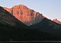
North aspect at sunset, from Waterton Lake
-
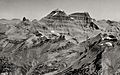
Aerial view from the south, circa 1925.
-

Mount Cleveland, left of center


